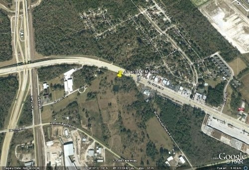
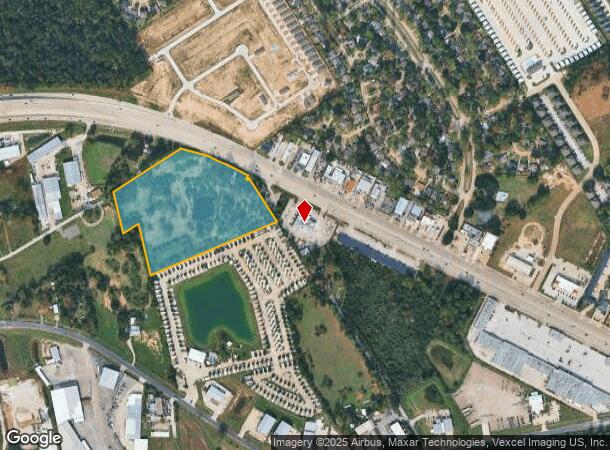
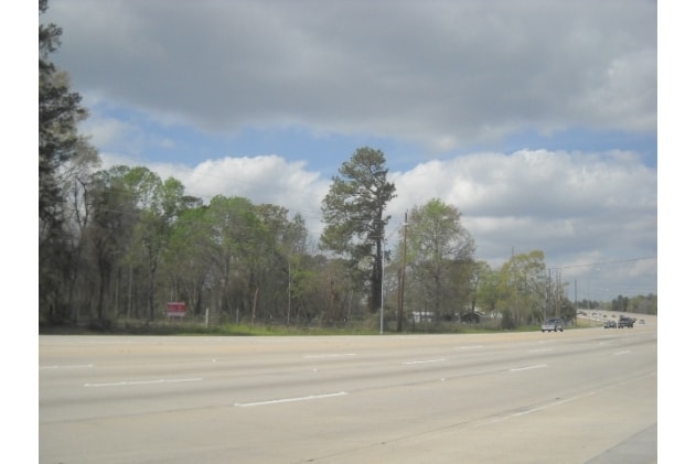
Property Record
2020 Fm 1960 Rd, Houston, TX 77073
NEARBY LISTINGS FOR SALE OR LEASE
Property Detail
2020 Fm 1960 Rd
Houston-The Woodlands-Sugar Land, TX
Northlake Rv
1334760010001
RES A BLK 1 NORTHLAKE RV
Agriculturalland
Harris
X
Texas
48339C0700F
12.63 AC
2024
Greenspoint/IAH
2025
Houston
240400
DEMOGRAPHICS near 2020 Fm 1960 Rd
1 Mile
3 Mile
5 Mile
2024 Total Population
6,871
88,114
221,242
2029 Population
7,034
89,959
226,986
Pop Growth 2024-2029
+ 2.37%
+ 2.09%
+ 2.60%
Average Age
33
34
34
2024 Total Households
2,207
30,125
75,931
HH Growth 2024-2029
+ 2.36%
+ 2.21%
+ 2.62%
Median Household Inc
$54,591
$52,514
$58,451
Avg Household Size
3.10
2.90
2.90
2024 Avg HH Vehicles
2.00
2.00
2.00
Median Home Value
$158,478
$163,053
$191,016
Median Year Built
1999
1993
1994
Nearby Places
Map Layers
Map Styles
 Street
 Aerial
- Restaurants
- Banks
- Shops
- Fitness
- Groceries
PUBLIC TRANSPORTATION
AIRPORT
George Bush Intcntl/Houston
DRIVE
WALK
Distance
George Bush Intcntl/Houston
15 min
11.0 mi
William P Hobby
DRIVE
WALK
Distance
William P Hobby
50 min
32.8 mi
Freight Ports
Port of Houston
DRIVE
WALK
Distance
Port of Houston
38 min
26.7 mi
SALE & LEASE HISTORY
LISTING DATE
SALE/LEASE

Aug 03, 2018
For Sale
Nearby Properties
Address
Land Use
TOTAL SIZE
Lot Size
Zoning
Address
Land Use
TOTAL SIZE
Lot Size
Zoning
764,495 SF
54.15 AC
Address
Land Use
TOTAL SIZE
Lot Size
Zoning
734,137 SF
11.37 AC
Address
Land Use
TOTAL SIZE
Lot Size
Zoning
276,324 SF
33.79 AC
Address
Land Use
TOTAL SIZE
Lot Size
Zoning
409,480 SF
27.32 AC
Address
Land Use
TOTAL SIZE
Lot Size
Zoning
288,721 SF
Address
Land Use
TOTAL SIZE
Lot Size
Zoning
417,597 SF
16.98 AC
Address
Land Use
TOTAL SIZE
Lot Size
Zoning
366,954 SF
18.88 AC
Address
Land Use
TOTAL SIZE
Lot Size
Zoning
350,423 SF
122.83 AC
Address
Land Use
TOTAL SIZE
Lot Size
Zoning
362,720 SF
20.23 AC
Address
Land Use
TOTAL SIZE
Lot Size
Zoning
280,283 SF
16.56 AC
Address
Land Use
TOTAL SIZE
Lot Size
Zoning
271,432 SF
35.81 AC
Address
Land Use
TOTAL SIZE
Lot Size
Zoning
472,399 SF
20.63 AC
Address
Land Use
TOTAL SIZE
Lot Size
Zoning
287,251 SF
18.12 AC
Address
Land Use
TOTAL SIZE
Lot Size
Zoning
291,504 SF
17.17 AC
Address
Land Use
TOTAL SIZE
Lot Size
Zoning
280,318 SF
14.66 AC
Address
Land Use
TOTAL SIZE
Lot Size
Zoning
174,349 SF
9.95 AC
Address
Land Use
TOTAL SIZE
Lot Size
Zoning
463,081 SF
25.65 AC
Address
Land Use
TOTAL SIZE
Lot Size
Zoning
283,283 SF
15.14 AC
Address
Land Use
TOTAL SIZE
Lot Size
Zoning
259,000 SF
15.73 AC
Address
Land Use
TOTAL SIZE
Lot Size
Zoning
259,000 SF
14.73 AC
Address
Land Use
TOTAL SIZE
Lot Size
Zoning
249,134 SF
11.85 AC
Address
Land Use
TOTAL SIZE
Lot Size
Zoning
244,846 SF
10.03 AC
Address
Land Use
TOTAL SIZE
Lot Size
Zoning
365,298 SF
15.28 AC
Address
Land Use
TOTAL SIZE
Lot Size
Zoning
357,485 SF
19.38 AC
Address
Land Use
TOTAL SIZE
Lot Size
Zoning
204,870 SF
13.40 AC
Address
Land Use
TOTAL SIZE
Lot Size
Zoning
203,013 SF
12.28 AC
Address
Land Use
TOTAL SIZE
Lot Size
Zoning
174,751 SF
10.49 AC
Address
Land Use
TOTAL SIZE
Lot Size
Zoning
200,378 SF
11.32 AC
Address
Land Use
TOTAL SIZE
Lot Size
Zoning
106,040 SF
14.63 AC
Address
Land Use
TOTAL SIZE
Lot Size
Zoning
241,244 SF
10.92 AC
The World's #1 Commercial Real Estate Marketplace
Connect with us
© 2025 CoStar Group
The information above has been obtained from sources believed reliable. While we do not doubt its accuracy we have not verified it and make no guarantee, warranty or representation about it. It is your responsibility to independently confirm its accuracy and completeness. Any projections, opinions, assumptions, or estimates used are for example only and do not represent the current or future performance of the property. The value of this transaction to you depends on tax and other factors which should be evaluated by your tax, financial, and legal advisors. You and your advisors should conduct a careful, independent investigation of the property to determine to your satisfaction the suitability of the property for your needs.