Property Record
7926 Fm 359 Rd S, Fulshear, TX 77441

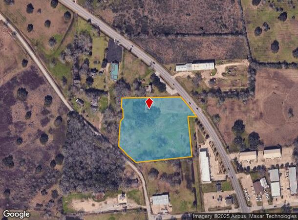
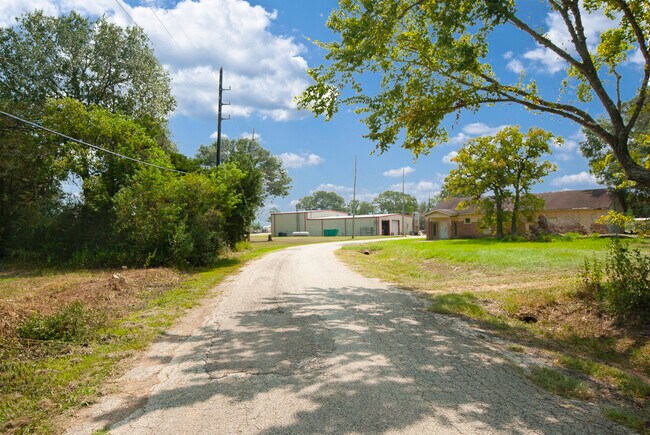
This Property Is For Sale
NEARBY LISTINGS FOR SALE OR LEASE
-
-
-
-
-
-
-
00 NWC OF UNION CHAPEL and Residential-0.88A Blvd
Fulshear, TX 77441
Rent Upon Request
0.88 AC Lots
Land
-
-
-
-
-
-
-
-
-
-
-
View all Fulshear listings for sale on LoopNet.com
Property Detail
7926 Fm 359 Rd S
0029-00-000-0883-901
C Fulshear
Sfr
0029 C FULSHEAR, ACRES 4.7332
X
Fort Bend
48157C0085M
Texas
2024
4.74 AC
2025
Southwest Outlier
673202
Houston
2,536 SF
Houston-Pasadena-The Woodlands, TX
DEMOGRAPHICS near 7926 Fm 359 Rd S
1 mile
3 mile
5 mile
2024 Total Population
2,734
24,089
96,162
2029 Population
3,439
29,950
117,938
Pop Growth 2024-2029
+ 25.79%
+ 24.33%
+ 22.65%
Average Age
37
37
35
2024 Total Households
887
7,720
28,970
HH Growth 2024-2029
+ 26.27%
+ 25.16%
+ 23.51%
Median Household Inc
$124,897
$134,836
$140,825
Avg Household Size
3.10
3.10
3.30
2024 Avg HH Vehicles
2.00
2.00
2.00
Median Home Value
$451,153
$455,002
$413,572
Median Year Built
2011
2011
2011
Nearby Places
Map Layers
Map Styles
 Street
 Aerial
Transit
 Traffic
 Biking
Places
Listings with unknown addresses are not visible on the map
- Restaurants
- Banks
- Shops
- Fitness
- Groceries
Nearby Properties
Address
Land Use
TOTAL SIZE
Lot Size
Zoning
Address
Land Use
TOTAL SIZE
Lot Size
Zoning
83.43 AC
Address
Land Use
TOTAL SIZE
Lot Size
Zoning
Address
Land Use
TOTAL SIZE
Lot Size
Zoning
14.80 AC
Address
Land Use
TOTAL SIZE
Lot Size
Zoning
4.73 AC
Z
Address
Land Use
TOTAL SIZE
Lot Size
Zoning
14.88 AC
Address
Land Use
TOTAL SIZE
Lot Size
Zoning
Address
Land Use
TOTAL SIZE
Lot Size
Zoning
12.58 AC
Address
Land Use
TOTAL SIZE
Lot Size
Zoning
6,725 SF
23.26 AC
S
Address
Land Use
TOTAL SIZE
Lot Size
Zoning
Address
Land Use
TOTAL SIZE
Lot Size
Zoning
25,956 SF
16.56 AC
S
Address
Land Use
TOTAL SIZE
Lot Size
Zoning
58,037 SF
18.96 AC
QXS
Address
Land Use
TOTAL SIZE
Lot Size
Zoning
5.10 AC
Address
Land Use
TOTAL SIZE
Lot Size
Zoning
14.98 AC
Address
Land Use
TOTAL SIZE
Lot Size
Zoning
9.26 AC
Address
Land Use
TOTAL SIZE
Lot Size
Zoning
296.94 AC
YQO
Address
Land Use
TOTAL SIZE
Lot Size
Zoning
3.78 AC
Address
Land Use
TOTAL SIZE
Lot Size
Zoning
6.69 AC
Address
Land Use
TOTAL SIZE
Lot Size
Zoning
26.67 AC
Address
Land Use
TOTAL SIZE
Lot Size
Zoning
15,974 SF
29.79 AC
S
Address
Land Use
TOTAL SIZE
Lot Size
Zoning
86.07 AC
S
Address
Land Use
TOTAL SIZE
Lot Size
Zoning
88,550 SF
7.53 AC
YNS
Address
Land Use
TOTAL SIZE
Lot Size
Zoning
9.92 AC
QSY
Address
Land Use
TOTAL SIZE
Lot Size
Zoning
14.01 AC
TS
Address
Land Use
TOTAL SIZE
Lot Size
Zoning
6.40 AC
Address
Land Use
TOTAL SIZE
Lot Size
Zoning
1,105 SF
196.73 AC
QTYS
Address
Land Use
TOTAL SIZE
Lot Size
Zoning
22.21 AC
Address
Land Use
TOTAL SIZE
Lot Size
Zoning
1,072 SF
2.83 AC
SY
Address
Land Use
TOTAL SIZE
Lot Size
Zoning
2.49 AC
Address
Land Use
TOTAL SIZE
Lot Size
Zoning
80.22 AC
Address
Land Use
TOTAL SIZE
Lot Size
Zoning
69.68 AC
The World's #1 Commercial Real Estate Marketplace
Connect with us
© 2026 CoStar Group
The information above has been obtained from sources believed reliable. While we do not doubt its accuracy we have not verified it and make no guarantee, warranty or representation about it. It is your responsibility to independently confirm its accuracy and completeness. Any projections, opinions, assumptions, or estimates used are for example only and do not represent the current or future performance of the property. The value of this transaction to you depends on tax and other factors which should be evaluated by your tax, financial, and legal advisors. You and your advisors should conduct a careful, independent investigation of the property to determine to your satisfaction the suitability of the property for your needs.