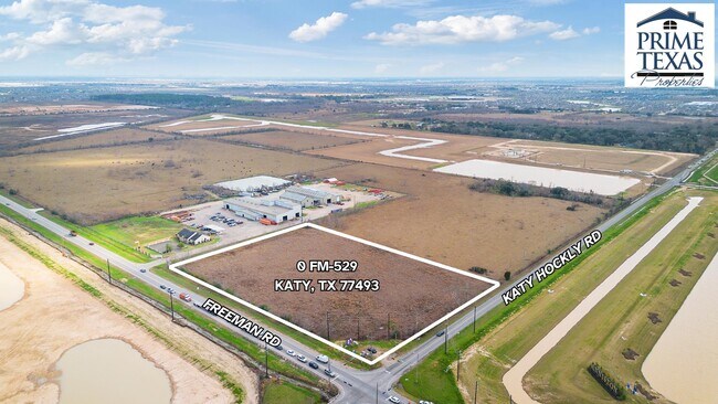
Property Record
0 Fm 529, Katy, TX 77493


Save to a Folder
{{folder.Name}}
{{folder.ListingIds.length}} Properties
{{folder.ListingIds.length}} Property
Create a New Folder
Property Detail
0 Fm 529
Houston-Pasadena-The Woodlands, TX
TR 1A-1 ABST 1395 H&TCRR SEC 68 BLK 2
0471670000012
HARRIS
Vacantlandnec
Texas
AE The base floodplain where base flood elevations are provided. AE Zones are now used on new format FIRMs instead of A1-A30 Zones.
6.21 AC
2025
Katy/Grand Parkway West
2025
Houston
542800
NEARBY LISTINGS FOR SALE OR LEASE
DEMOGRAPHICS near 0 Fm 529
1 mile
3 mile
5 mile
2025 Total Population
442
19,858
64,007
2030 Population
511
22,886
72,564
Pop Growth 2025-2030
+ 15.61%
+ 15.25%
+ 13.37%
Average Age
34
33
34
2025 Total Households
129
5,936
19,443
HH Growth 2025-2030
+ 15.50%
+ 15.46%
+ 13.57%
Median Household Inc
$116,406
$131,072
$119,032
Avg Household Size
3.20
3.30
3.30
2025 Avg HH Vehicles
3.00
2.00
2.00
Median Home Value
$354,761
$371,821
$363,459
Median Year Built
2011
2011
2011
Nearby Places
Map Layers
Map Styles
 Street
 Aerial
Layers
 Traffic
 Biking
Places
Listings with unknown addresses are not visible on the map
- Restaurants
- Banks
- Shops
- Fitness
- Groceries
PUBLIC TRANSPORTATION
AIRPORT
George Bush Intcntl/Houston
Drive
Walk
Distance
George Bush Intcntl/Houston
52 min
34.8 mi
Freight Ports
Port of Houston
Drive
Walk
Distance
Port of Houston
62 min
41.0 mi
SALE & LEASE HISTORY
LISTING DATE
SALE/LEASE

Nov 01, 2017
For Sale
May 10, 2024
For Sale
Nearby Properties
Address
Land Use
TOTAL SIZE
Lot Size
Zoning
Address
Land Use
TOTAL SIZE
Lot Size
Zoning
78.32 AC
Address
Land Use
TOTAL SIZE
Lot Size
Zoning
131,811 SF
29.47 AC
Address
Land Use
TOTAL SIZE
Lot Size
Zoning
277.23 AC
Address
Land Use
TOTAL SIZE
Lot Size
Zoning
86,378 SF
5.50 AC
Address
Land Use
TOTAL SIZE
Lot Size
Zoning
40,200 SF
2.95 AC
Address
Land Use
TOTAL SIZE
Lot Size
Zoning
22,620 SF
7.55 AC
Address
Land Use
TOTAL SIZE
Lot Size
Zoning
167,944 SF
12 AC
Address
Land Use
TOTAL SIZE
Lot Size
Zoning
111,361 SF
15 AC
Address
Land Use
TOTAL SIZE
Lot Size
Zoning
111.36 AC
Address
Land Use
TOTAL SIZE
Lot Size
Zoning
28,569 SF
19.20 AC
Address
Land Use
TOTAL SIZE
Lot Size
Zoning
92.39 AC
Address
Land Use
TOTAL SIZE
Lot Size
Zoning
42,000 SF
3.25 AC
Address
Land Use
TOTAL SIZE
Lot Size
Zoning
157.56 AC
Address
Land Use
TOTAL SIZE
Lot Size
Zoning
22,320 SF
2.60 AC
Address
Land Use
TOTAL SIZE
Lot Size
Zoning
237.62 AC
Address
Land Use
TOTAL SIZE
Lot Size
Zoning
32,675 SF
3.02 AC
Address
Land Use
TOTAL SIZE
Lot Size
Zoning
25,864 SF
4.46 AC
Address
Land Use
TOTAL SIZE
Lot Size
Zoning
145.57 AC
Address
Land Use
TOTAL SIZE
Lot Size
Zoning
274.70 AC
Address
Land Use
TOTAL SIZE
Lot Size
Zoning
5,756 SF
4.58 AC
Address
Land Use
TOTAL SIZE
Lot Size
Zoning
84,600 SF
13.41 AC
Address
Land Use
TOTAL SIZE
Lot Size
Zoning
262.42 AC
Address
Land Use
TOTAL SIZE
Lot Size
Zoning
Address
Land Use
TOTAL SIZE
Lot Size
Zoning
124.17 AC
Address
Land Use
TOTAL SIZE
Lot Size
Zoning
21,000 SF
3.95 AC
Address
Land Use
TOTAL SIZE
Lot Size
Zoning
220.85 AC
Address
Land Use
TOTAL SIZE
Lot Size
Zoning
89.67 AC
Address
Land Use
TOTAL SIZE
Lot Size
Zoning
494.32 AC
Address
Land Use
TOTAL SIZE
Lot Size
Zoning
12.66 AC
Address
Land Use
TOTAL SIZE
Lot Size
Zoning
33.69 AC
The World's #1 Commercial Real Estate Marketplace
Connect with us
© 2026 CoStar Group
The information above has been obtained from sources believed reliable. While we do not doubt its accuracy we have not verified it and make no guarantee, warranty or representation about it. It is your responsibility to independently confirm its accuracy and completeness. Any projections, opinions, assumptions, or estimates used are for example only and do not represent the current or future performance of the property. The value of this transaction to you depends on tax and other factors which should be evaluated by your tax, financial, and legal advisors. You and your advisors should conduct a careful, independent investigation of the property to determine to your satisfaction the suitability of the property for your needs.