Property Record
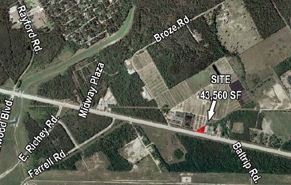
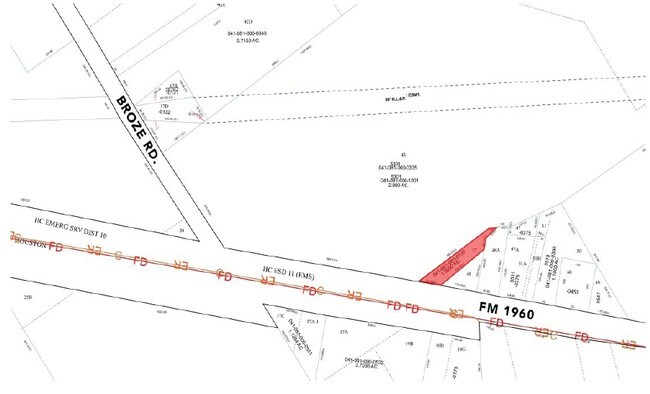
0 Fm Rd E, Humble, TX 77338

Property Detail
0 Fm Rd E
Houston-Pasadena-The Woodlands, TX
TRS 11 & 20 ABST 125 A BARBER
0410810000090
HARRIS
Agriculturalland
Texas
AE The base floodplain where base flood elevations are provided. AE Zones are now used on new format FIRMs instead of A1-A30 Zones.
24.05 AC
2024
Kingwood/Humble
2025
Houston
240904
NEARBY LISTINGS FOR SALE OR LEASE
DEMOGRAPHICS near 0 Fm Rd E
1 mile
3 mile
5 mile
2025 Total Population
1,099
52,540
155,971
2030 Population
1,197
56,425
167,335
Pop Growth 2025-2030
+ 8.92%
+ 7.39%
+ 7.29%
Average Age
31
35
35
2025 Total Households
403
16,707
50,008
HH Growth 2025-2030
+ 8.93%
+ 7.61%
+ 7.56%
Median Household Inc
$40,875
$78,531
$75,680
Avg Household Size
2.70
3.10
3.10
2025 Avg HH Vehicles
2.00
2.00
2.00
Median Home Value
$250,624
$232,460
$236,614
Median Year Built
2004
1998
2000
Nearby Places
Map Layers
Map Styles
 Street
 Aerial
Transit
 Traffic
 Biking
Places
Listings with unknown addresses are not visible on the map
- Restaurants
- Banks
- Shops
- Fitness
- Groceries
PUBLIC TRANSPORTATION
AIRPORT
George Bush Intcntl/Houston
Drive
Walk
Distance
George Bush Intcntl/Houston
16 min
8.5 mi
William P Hobby
Drive
Walk
Distance
William P Hobby
52 min
33.7 mi
Freight Ports
Port of Houston
Drive
Walk
Distance
Port of Houston
40 min
27.7 mi
Nearby Properties
Address
Land Use
TOTAL SIZE
Lot Size
Zoning
Address
Land Use
TOTAL SIZE
Lot Size
Zoning
276,324 SF
33.79 AC
Address
Land Use
TOTAL SIZE
Lot Size
Zoning
350,423 SF
122.83 AC
Address
Land Use
TOTAL SIZE
Lot Size
Zoning
280,283 SF
16.56 AC
Address
Land Use
TOTAL SIZE
Lot Size
Zoning
435,650 SF
Address
Land Use
TOTAL SIZE
Lot Size
Zoning
318,000 SF
18.53 AC
Address
Land Use
TOTAL SIZE
Lot Size
Zoning
199,368 SF
8.16 AC
Address
Land Use
TOTAL SIZE
Lot Size
Zoning
203,013 SF
12.28 AC
Address
Land Use
TOTAL SIZE
Lot Size
Zoning
175,495 SF
8.92 AC
Address
Land Use
TOTAL SIZE
Lot Size
Zoning
159,480 SF
12.23 AC
Address
Land Use
TOTAL SIZE
Lot Size
Zoning
99,561 SF
11.60 AC
Address
Land Use
TOTAL SIZE
Lot Size
Zoning
146,503 SF
6.12 AC
Address
Land Use
TOTAL SIZE
Lot Size
Zoning
125,674 SF
11.56 AC
Address
Land Use
TOTAL SIZE
Lot Size
Zoning
281,563 SF
19.98 AC
Address
Land Use
TOTAL SIZE
Lot Size
Zoning
152,440 SF
24.67 AC
Address
Land Use
TOTAL SIZE
Lot Size
Zoning
115,000 SF
7.83 AC
Address
Land Use
TOTAL SIZE
Lot Size
Zoning
126,320 SF
12.11 AC
Address
Land Use
TOTAL SIZE
Lot Size
Zoning
98,218 SF
29.44 AC
Address
Land Use
TOTAL SIZE
Lot Size
Zoning
106,901 SF
6.70 AC
Address
Land Use
TOTAL SIZE
Lot Size
Zoning
78,116 SF
6.49 AC
Address
Land Use
TOTAL SIZE
Lot Size
Zoning
182,390 SF
47.72 AC
Address
Land Use
TOTAL SIZE
Lot Size
Zoning
56,524 SF
9.46 AC
Address
Land Use
TOTAL SIZE
Lot Size
Zoning
100,408 SF
5.18 AC
Address
Land Use
TOTAL SIZE
Lot Size
Zoning
79,899 SF
7.05 AC
Address
Land Use
TOTAL SIZE
Lot Size
Zoning
58.19 AC
Address
Land Use
TOTAL SIZE
Lot Size
Zoning
55,580 SF
7.78 AC
Address
Land Use
TOTAL SIZE
Lot Size
Zoning
6.72 AC
Address
Land Use
TOTAL SIZE
Lot Size
Zoning
241,100 SF
20.06 AC
Address
Land Use
TOTAL SIZE
Lot Size
Zoning
75,600 SF
8.36 AC
Address
Land Use
TOTAL SIZE
Lot Size
Zoning
4,282 SF
25.88 AC
Address
Land Use
TOTAL SIZE
Lot Size
Zoning
117,500 SF
6.36 AC
The World's #1 Commercial Real Estate Marketplace
Connect with us
© 2026 CoStar Group
The information above has been obtained from sources believed reliable. While we do not doubt its accuracy we have not verified it and make no guarantee, warranty or representation about it. It is your responsibility to independently confirm its accuracy and completeness. Any projections, opinions, assumptions, or estimates used are for example only and do not represent the current or future performance of the property. The value of this transaction to you depends on tax and other factors which should be evaluated by your tax, financial, and legal advisors. You and your advisors should conduct a careful, independent investigation of the property to determine to your satisfaction the suitability of the property for your needs.