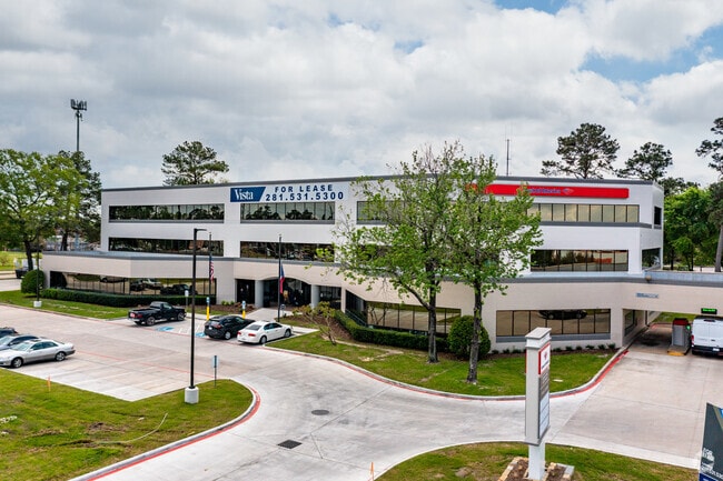
Property Record
0 Fm Rd E, Humble, TX 77338
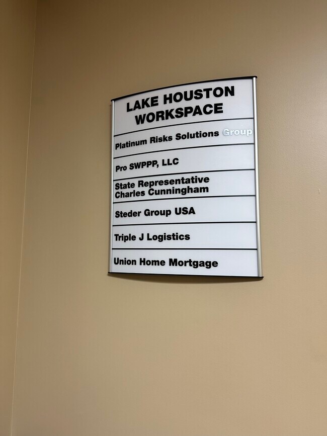

Current Lease Availabilities
Property Detail
0 Fm Rd E
Houston-Pasadena-The Woodlands, TX
RES A BLK 1 ATASCOCITA OFFICE PARK SEC 1
0431500050021
HARRIS
Religious
Texas
B and X Area of moderate flood hazard, usually the area between the limits of the 100-year and 500-year floods.
0.63 AC
2025
Northeast Outlier
2025
Houston
250404
NEARBY LISTINGS FOR SALE OR LEASE
DEMOGRAPHICS near 0 Fm Rd E
1 mile
3 mile
5 mile
2025 Total Population
13,506
73,077
148,349
2030 Population
14,252
77,858
158,876
Pop Growth 2025-2030
+ 5.52%
+ 6.54%
+ 7.10%
Average Age
40
38
38
2025 Total Households
4,663
24,611
50,160
HH Growth 2025-2030
+ 5.60%
+ 6.71%
+ 7.28%
Median Household Inc
$103,886
$114,451
$114,909
Avg Household Size
2.90
2.90
2.90
2025 Avg HH Vehicles
2.00
2.00
2.00
Median Home Value
$295,887
$321,796
$335,045
Median Year Built
1994
2002
2001
Nearby Places
Map Layers
Map Styles
 Street
 Aerial
Layers
 Traffic
 Biking
Places
Listings with unknown addresses are not visible on the map
- Restaurants
- Banks
- Shops
- Fitness
- Groceries
PUBLIC TRANSPORTATION
AIRPORT
George Bush Intcntl/Houston
Drive
Walk
Distance
George Bush Intcntl/Houston
14 min
9.6 mi
William P Hobby
Drive
Walk
Distance
William P Hobby
47 min
31.2 mi
Freight Ports
Port of Houston
Drive
Walk
Distance
Port of Houston
36 min
24.9 mi
Nearby Properties
Address
Land Use
TOTAL SIZE
Lot Size
Zoning
Address
Land Use
TOTAL SIZE
Lot Size
Zoning
687,195 SF
33.75 AC
Address
Land Use
TOTAL SIZE
Lot Size
Zoning
685,400 SF
38.82 AC
Address
Land Use
TOTAL SIZE
Lot Size
Zoning
514,500 SF
40.85 AC
Address
Land Use
TOTAL SIZE
Lot Size
Zoning
604,908 SF
58.67 AC
Address
Land Use
TOTAL SIZE
Lot Size
Zoning
429,750 SF
24.74 AC
Address
Land Use
TOTAL SIZE
Lot Size
Zoning
391,060 SF
32.42 AC
Address
Land Use
TOTAL SIZE
Lot Size
Zoning
355,622 SF
15.78 AC
Address
Land Use
TOTAL SIZE
Lot Size
Zoning
432,617 SF
19.41 AC
Address
Land Use
TOTAL SIZE
Lot Size
Zoning
320,200 SF
19.56 AC
Address
Land Use
TOTAL SIZE
Lot Size
Zoning
212,020 SF
Address
Land Use
TOTAL SIZE
Lot Size
Zoning
449,858 SF
22.20 AC
Address
Land Use
TOTAL SIZE
Lot Size
Zoning
201,363 SF
24.98 AC
5
Address
Land Use
TOTAL SIZE
Lot Size
Zoning
235,236 SF
15.14 AC
Address
Land Use
TOTAL SIZE
Lot Size
Zoning
309,744 SF
21.50 AC
Address
Land Use
TOTAL SIZE
Lot Size
Zoning
216,978 SF
10.99 AC
Address
Land Use
TOTAL SIZE
Lot Size
Zoning
252,320 SF
22.14 AC
Address
Land Use
TOTAL SIZE
Lot Size
Zoning
205,040 SF
10.51 AC
Address
Land Use
TOTAL SIZE
Lot Size
Zoning
268,939 SF
11.24 AC
Address
Land Use
TOTAL SIZE
Lot Size
Zoning
242,788 SF
14.72 AC
Address
Land Use
TOTAL SIZE
Lot Size
Zoning
304,671 SF
14.77 AC
Address
Land Use
TOTAL SIZE
Lot Size
Zoning
196,468 SF
9.51 AC
Address
Land Use
TOTAL SIZE
Lot Size
Zoning
207,432 SF
15.12 AC
Address
Land Use
TOTAL SIZE
Lot Size
Zoning
208,230 SF
14.79 AC
Address
Land Use
TOTAL SIZE
Lot Size
Zoning
165,737 SF
14 AC
Address
Land Use
TOTAL SIZE
Lot Size
Zoning
102,374 SF
13.48 AC
Address
Land Use
TOTAL SIZE
Lot Size
Zoning
156,756 SF
17.05 AC
Address
Land Use
TOTAL SIZE
Lot Size
Zoning
64,980 SF
4.19 AC
Address
Land Use
TOTAL SIZE
Lot Size
Zoning
56,344 SF
3.25 AC
Address
Land Use
TOTAL SIZE
Lot Size
Zoning
206,600 SF
23.09 AC
Address
Land Use
TOTAL SIZE
Lot Size
Zoning
168,400 SF
11.57 AC
The World's #1 Commercial Real Estate Marketplace
Connect with us
© 2026 CoStar Group
The information above has been obtained from sources believed reliable. While we do not doubt its accuracy we have not verified it and make no guarantee, warranty or representation about it. It is your responsibility to independently confirm its accuracy and completeness. Any projections, opinions, assumptions, or estimates used are for example only and do not represent the current or future performance of the property. The value of this transaction to you depends on tax and other factors which should be evaluated by your tax, financial, and legal advisors. You and your advisors should conduct a careful, independent investigation of the property to determine to your satisfaction the suitability of the property for your needs.