Property Record
0 Fm Rd W, Spring, TX 77338
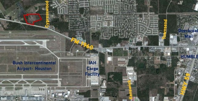

Property Detail
0 Fm Rd W
Houston-Pasadena-The Woodlands, TX
RES A BLK 1 NORTHEAST HOUSTON HOSPITAL R/P
1308970010001
HARRIS
Commercialacreage
Texas
B and X Area of moderate flood hazard, usually the area between the limits of the 100-year and 500-year floods.
41.97 AC
0
Kingwood/Humble
2025
Houston
240904
NEARBY LISTINGS FOR SALE OR LEASE
DEMOGRAPHICS near 0 Fm Rd W
1 mile
3 mile
5 mile
2025 Total Population
3,108
50,094
135,133
2030 Population
3,346
53,668
145,086
Pop Growth 2025-2030
+ 7.66%
+ 7.13%
+ 7.37%
Average Age
36
35
35
2025 Total Households
954
15,949
43,085
HH Growth 2025-2030
+ 7.86%
+ 7.34%
+ 7.61%
Median Household Inc
$97,999
$77,577
$78,104
Avg Household Size
3.20
3.10
3.10
2025 Avg HH Vehicles
2.00
2.00
2.00
Median Home Value
$252,281
$237,127
$234,979
Median Year Built
2003
2000
2000
Nearby Places
Map Layers
Map Styles
 Street
 Aerial
Transit
 Traffic
 Biking
Places
Listings with unknown addresses are not visible on the map
- Restaurants
- Banks
- Shops
- Fitness
- Groceries
PUBLIC TRANSPORTATION
AIRPORT
George Bush Intcntl/Houston
Drive
Walk
Distance
George Bush Intcntl/Houston
14 min
7.7 mi
William P Hobby
Drive
Walk
Distance
William P Hobby
51 min
33.5 mi
Freight Ports
Port of Houston
Drive
Walk
Distance
Port of Houston
40 min
27.1 mi
Nearby Properties
Address
Land Use
TOTAL SIZE
Lot Size
Zoning
Address
Land Use
TOTAL SIZE
Lot Size
Zoning
391,060 SF
32.42 AC
Address
Land Use
TOTAL SIZE
Lot Size
Zoning
355,622 SF
15.78 AC
Address
Land Use
TOTAL SIZE
Lot Size
Zoning
280,283 SF
16.56 AC
Address
Land Use
TOTAL SIZE
Lot Size
Zoning
334,510 SF
23.54 AC
Address
Land Use
TOTAL SIZE
Lot Size
Zoning
435,650 SF
Address
Land Use
TOTAL SIZE
Lot Size
Zoning
318,000 SF
18.53 AC
Address
Land Use
TOTAL SIZE
Lot Size
Zoning
235,236 SF
15.14 AC
Address
Land Use
TOTAL SIZE
Lot Size
Zoning
309,744 SF
21.50 AC
Address
Land Use
TOTAL SIZE
Lot Size
Zoning
216,978 SF
10.99 AC
Address
Land Use
TOTAL SIZE
Lot Size
Zoning
252,320 SF
22.14 AC
Address
Land Use
TOTAL SIZE
Lot Size
Zoning
242,788 SF
14.72 AC
Address
Land Use
TOTAL SIZE
Lot Size
Zoning
199,368 SF
8.16 AC
Address
Land Use
TOTAL SIZE
Lot Size
Zoning
208,230 SF
14.79 AC
Address
Land Use
TOTAL SIZE
Lot Size
Zoning
175,495 SF
8.92 AC
Address
Land Use
TOTAL SIZE
Lot Size
Zoning
168,400 SF
11.57 AC
Address
Land Use
TOTAL SIZE
Lot Size
Zoning
196,200 SF
16.86 AC
Address
Land Use
TOTAL SIZE
Lot Size
Zoning
162,738 SF
11.25 AC
Address
Land Use
TOTAL SIZE
Lot Size
Zoning
63,507 SF
2.83 AC
Address
Land Use
TOTAL SIZE
Lot Size
Zoning
159,480 SF
12.23 AC
Address
Land Use
TOTAL SIZE
Lot Size
Zoning
150,000 SF
13.09 AC
Address
Land Use
TOTAL SIZE
Lot Size
Zoning
99,561 SF
11.60 AC
Address
Land Use
TOTAL SIZE
Lot Size
Zoning
133,700 SF
12.82 AC
Address
Land Use
TOTAL SIZE
Lot Size
Zoning
96,875 SF
8.09 AC
Address
Land Use
TOTAL SIZE
Lot Size
Zoning
146,503 SF
6.12 AC
Address
Land Use
TOTAL SIZE
Lot Size
Zoning
125,674 SF
11.56 AC
Address
Land Use
TOTAL SIZE
Lot Size
Zoning
152,440 SF
24.67 AC
Address
Land Use
TOTAL SIZE
Lot Size
Zoning
115,000 SF
7.83 AC
Address
Land Use
TOTAL SIZE
Lot Size
Zoning
106,901 SF
6.70 AC
Address
Land Use
TOTAL SIZE
Lot Size
Zoning
56,524 SF
9.46 AC
Address
Land Use
TOTAL SIZE
Lot Size
Zoning
79,899 SF
7.05 AC
The World's #1 Commercial Real Estate Marketplace
Connect with us
© 2026 CoStar Group
The information above has been obtained from sources believed reliable. While we do not doubt its accuracy we have not verified it and make no guarantee, warranty or representation about it. It is your responsibility to independently confirm its accuracy and completeness. Any projections, opinions, assumptions, or estimates used are for example only and do not represent the current or future performance of the property. The value of this transaction to you depends on tax and other factors which should be evaluated by your tax, financial, and legal advisors. You and your advisors should conduct a careful, independent investigation of the property to determine to your satisfaction the suitability of the property for your needs.