Property Record
Forest Trace Rd, Richards, TX 77873
Property Detail
Forest Trace Rd
Houston-Pasadena-The Woodlands, TX
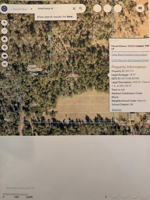
Fares Wm
0210-00-00740
A0210 - FARES WM, TRACT 7-E, ACRES 14.97
Vacantlandnec
Montgomery
AE
Texas
48339C0075G
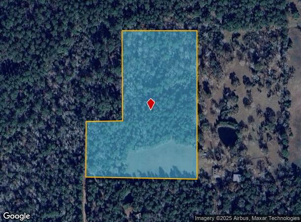
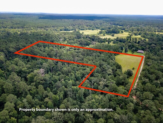
14.97 AC
2024
Outlying Montgomery Cnty
2025
Houston
694700
NEARBY LISTINGS FOR SALE OR LEASE
-
-
View all Richards listings for sale on LoopNet.com
DEMOGRAPHICS near Forest Trace Rd
1 mile
3 mile
5 mile
2024 Total Population
88
274
855
2029 Population
108
335
1,015
Pop Growth 2024-2029
+ 22.73%
+ 22.26%
+ 18.71%
Average Age
43
44
43
2024 Total Households
34
108
327
HH Growth 2024-2029
+ 23.53%
+ 22.22%
+ 18.96%
Median Household Inc
$102,083
$102,631
$74,721
Avg Household Size
2.60
2.50
2.60
2024 Avg HH Vehicles
2.00
2.00
2.00
Median Home Value
$399,999
$450,000
$342,307
Median Year Built
2000
2000
1996
Nearby Places
Map Layers
Map Styles
 Street
 Aerial
Transit
 Traffic
 Biking
Places
Listings with unknown addresses are not visible on the map
- Restaurants
- Banks
- Shops
- Fitness
- Groceries
SALE & LEASE HISTORY
LISTING DATE
SALE/LEASE

Jun 30, 2021
For Sale
Nearby Properties
Address
Land Use
TOTAL SIZE
Lot Size
Zoning
Address
Land Use
TOTAL SIZE
Lot Size
Zoning
3,906.85 AC
3
Address
Land Use
TOTAL SIZE
Lot Size
Zoning
1.33 AC
3
Address
Land Use
TOTAL SIZE
Lot Size
Zoning
1,880.30 AC
3
Address
Land Use
TOTAL SIZE
Lot Size
Zoning
711 AC
3
Address
Land Use
TOTAL SIZE
Lot Size
Zoning
650 AC
3
Address
Land Use
TOTAL SIZE
Lot Size
Zoning
647 AC
3
Address
Land Use
TOTAL SIZE
Lot Size
Zoning
449 AC
3
Address
Land Use
TOTAL SIZE
Lot Size
Zoning
384 AC
3
Address
Land Use
TOTAL SIZE
Lot Size
Zoning
338 AC
3
Address
Land Use
TOTAL SIZE
Lot Size
Zoning
316 AC
3
Address
Land Use
TOTAL SIZE
Lot Size
Zoning
196.50 AC
3
Address
Land Use
TOTAL SIZE
Lot Size
Zoning
151 AC
3
Address
Land Use
TOTAL SIZE
Lot Size
Zoning
130 AC
3
Address
Land Use
TOTAL SIZE
Lot Size
Zoning
106.75 AC
3
Address
Land Use
TOTAL SIZE
Lot Size
Zoning
100 AC
3
Address
Land Use
TOTAL SIZE
Lot Size
Zoning
18,600 SF
6 AC
Address
Land Use
TOTAL SIZE
Lot Size
Zoning
2,480 SF
90.02 AC
3
Address
Land Use
TOTAL SIZE
Lot Size
Zoning
65 AC
3
Address
Land Use
TOTAL SIZE
Lot Size
Zoning
5,432 SF
33.66 AC
3
Address
Land Use
TOTAL SIZE
Lot Size
Zoning
50 AC
3
Address
Land Use
TOTAL SIZE
Lot Size
Zoning
2,796 SF
11.81 AC
3
Address
Land Use
TOTAL SIZE
Lot Size
Zoning
5,138 SF
11 AC
3
Address
Land Use
TOTAL SIZE
Lot Size
Zoning
40 AC
3
Address
Land Use
TOTAL SIZE
Lot Size
Zoning
7,052 SF
11.36 AC
Address
Land Use
TOTAL SIZE
Lot Size
Zoning
1,704 SF
9.95 AC
Address
Land Use
TOTAL SIZE
Lot Size
Zoning
3,741 SF
3.41 AC
Address
Land Use
TOTAL SIZE
Lot Size
Zoning
3,318 SF
19.21 AC
3
Address
Land Use
TOTAL SIZE
Lot Size
Zoning
2,065 SF
18.50 AC
Address
Land Use
TOTAL SIZE
Lot Size
Zoning
2,736 SF
14.87 AC
3
The World's #1 Commercial Real Estate Marketplace
Connect with us
© 2026 CoStar Group
The information above has been obtained from sources believed reliable. While we do not doubt its accuracy we have not verified it and make no guarantee, warranty or representation about it. It is your responsibility to independently confirm its accuracy and completeness. Any projections, opinions, assumptions, or estimates used are for example only and do not represent the current or future performance of the property. The value of this transaction to you depends on tax and other factors which should be evaluated by your tax, financial, and legal advisors. You and your advisors should conduct a careful, independent investigation of the property to determine to your satisfaction the suitability of the property for your needs.