Property Record
18 High Rd, Forsyth, GA 31029
NEARBY LISTINGS FOR SALE OR LEASE
-
-
View all Forsyth listings for sale on LoopNet.com
Property Detail
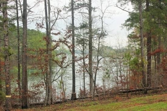
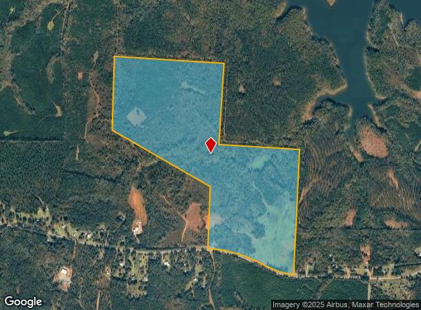
18 High Rd
Macon-Bibb County, GA
Southeast Monroe County
078-013B
LL 70,71,91 LD 5 PARCEL 2
Privatepreserveopenspacevacantlandforestlandconservation
Monroe
X
Georgia
13169C0125E
172.51 AC
2024
Monroe County
2025
Atlanta
050200
DEMOGRAPHICS near 18 High Rd
1 Mile
3 Mile
5 Mile
2024 Total Population
136
1,448
4,556
2029 Population
154
1,632
5,143
Pop Growth 2024-2029
+ 13.24%
+ 12.71%
+ 12.88%
Average Age
41
42
41
2024 Total Households
51
552
1,729
HH Growth 2024-2029
+ 13.73%
+ 13.41%
+ 13.48%
Median Household Inc
$64,687
$64,177
$62,743
Avg Household Size
2.60
2.60
2.60
2024 Avg HH Vehicles
2.00
2.00
2.00
Median Home Value
$187,499
$240,740
$246,900
Median Year Built
1991
1991
1991
Nearby Places
Map Layers
Map Styles
 Street
 Aerial
- Restaurants
- Banks
- Shops
- Fitness
- Groceries
SALE & LEASE HISTORY
LISTING DATE
SALE/LEASE

Oct 04, 2017
For Sale
Nearby Properties
Address
Land Use
TOTAL SIZE
Lot Size
Zoning
Address
Land Use
TOTAL SIZE
Lot Size
Zoning
11,998.01 AC
002
Address
Land Use
TOTAL SIZE
Lot Size
Zoning
4,549 SF
17.97 AC
Address
Land Use
TOTAL SIZE
Lot Size
Zoning
4,106 SF
1.03 AC
006
Address
Land Use
TOTAL SIZE
Lot Size
Zoning
2,670 SF
13.59 AC
005
Address
Land Use
TOTAL SIZE
Lot Size
Zoning
127.55 AC
005
Address
Land Use
TOTAL SIZE
Lot Size
Zoning
163.68 AC
Address
Land Use
TOTAL SIZE
Lot Size
Zoning
106.60 AC
Address
Land Use
TOTAL SIZE
Lot Size
Zoning
172.51 AC
005
Address
Land Use
TOTAL SIZE
Lot Size
Zoning
194 AC
005
Address
Land Use
TOTAL SIZE
Lot Size
Zoning
137.99 AC
005
Address
Land Use
TOTAL SIZE
Lot Size
Zoning
135 AC
005
Address
Land Use
TOTAL SIZE
Lot Size
Zoning
63.41 AC
005
Address
Land Use
TOTAL SIZE
Lot Size
Zoning
210.94 AC
005
Address
Land Use
TOTAL SIZE
Lot Size
Zoning
93.24 AC
Address
Land Use
TOTAL SIZE
Lot Size
Zoning
65.02 AC
Address
Land Use
TOTAL SIZE
Lot Size
Zoning
100 AC
005
Address
Land Use
TOTAL SIZE
Lot Size
Zoning
89.78 AC
005
Address
Land Use
TOTAL SIZE
Lot Size
Zoning
89.09 AC
Address
Land Use
TOTAL SIZE
Lot Size
Zoning
1,834 SF
52.85 AC
005
Address
Land Use
TOTAL SIZE
Lot Size
Zoning
94.40 AC
005
Address
Land Use
TOTAL SIZE
Lot Size
Zoning
1,487 SF
5 AC
Address
Land Use
TOTAL SIZE
Lot Size
Zoning
70.46 AC
005
Address
Land Use
TOTAL SIZE
Lot Size
Zoning
75.10 AC
005
Address
Land Use
TOTAL SIZE
Lot Size
Zoning
67 AC
005
Address
Land Use
TOTAL SIZE
Lot Size
Zoning
62.95 AC
005
Address
Land Use
TOTAL SIZE
Lot Size
Zoning
123.53 AC
005
Address
Land Use
TOTAL SIZE
Lot Size
Zoning
223.30 AC
005
Address
Land Use
TOTAL SIZE
Lot Size
Zoning
101 AC
005
Address
Land Use
TOTAL SIZE
Lot Size
Zoning
2,139 SF
7 AC
The World's #1 Commercial Real Estate Marketplace
Connect with us
© 2025 CoStar Group
The information above has been obtained from sources believed reliable. While we do not doubt its accuracy we have not verified it and make no guarantee, warranty or representation about it. It is your responsibility to independently confirm its accuracy and completeness. Any projections, opinions, assumptions, or estimates used are for example only and do not represent the current or future performance of the property. The value of this transaction to you depends on tax and other factors which should be evaluated by your tax, financial, and legal advisors. You and your advisors should conduct a careful, independent investigation of the property to determine to your satisfaction the suitability of the property for your needs.