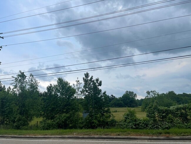
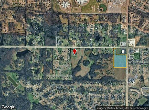
Property Record
2481 Church Rd E, Southaven, MS 38671

NEARBY LISTINGS FOR SALE OR LEASE
Property Detail
2481 Church Rd E
Memphis, TN-MS-AR
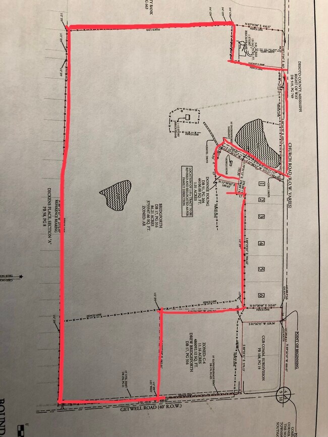
PT N1/2
2072090000000300
DeSoto
Vacantlandnec
Mississippi
X
3
28033C0090H
11 AC
2025
DeSoto County
2025
Memphis
070635
DEMOGRAPHICS near 2481 Church Rd E
1 mile
3 mile
5 mile
2024 Total Population
6,016
30,588
73,731
2029 Population
6,579
33,514
81,217
Pop Growth 2024-2029
+ 9.36%
+ 9.57%
+ 10.15%
Average Age
39
39
39
2024 Total Households
2,078
10,940
27,615
HH Growth 2024-2029
+ 9.34%
+ 9.54%
+ 10.20%
Median Household Inc
$108,022
$94,901
$73,322
Avg Household Size
2.80
2.70
2.60
2024 Avg HH Vehicles
2.00
2.00
2.00
Median Home Value
$251,444
$258,965
$244,058
Median Year Built
2005
2001
1999
Nearby Places
Map Layers
Map Styles
 Street
 Aerial
Transit
 Traffic
 Biking
Places
Listings with unknown addresses are not visible on the map
- Restaurants
- Banks
- Shops
- Fitness
- Groceries
PUBLIC TRANSPORTATION
AIRPORT
Memphis International
Drive
Walk
Distance
Memphis International
19 min
12.7 mi
Freight Ports
Port of Shreveport
Drive
Walk
Distance
Port of Shreveport
420 min
386.3 mi
SALE & LEASE HISTORY
LISTING DATE
SALE/LEASE

May 27, 2022
For Sale
Nearby Properties
Address
Land Use
TOTAL SIZE
Lot Size
Zoning
Address
Land Use
TOTAL SIZE
Lot Size
Zoning
62,561 SF
33.01 AC
PUD
Address
Land Use
TOTAL SIZE
Lot Size
Zoning
454,272 SF
22.28 AC
PBP
Address
Land Use
TOTAL SIZE
Lot Size
Zoning
262,006 SF
25.85 AC
PBP
Address
Land Use
TOTAL SIZE
Lot Size
Zoning
5,189 SF
9.62 AC
C-4
Address
Land Use
TOTAL SIZE
Lot Size
Zoning
13,129 SF
12 AC
PUD
Address
Land Use
TOTAL SIZE
Lot Size
Zoning
300,764 SF
22.13 AC
PBP
Address
Land Use
TOTAL SIZE
Lot Size
Zoning
10,341 SF
13.94 AC
RM-6
Address
Land Use
TOTAL SIZE
Lot Size
Zoning
5,384 SF
7.92 AC
PUD
Address
Land Use
TOTAL SIZE
Lot Size
Zoning
216,320 SF
30 AC
PBP
Address
Land Use
TOTAL SIZE
Lot Size
Zoning
62,730 SF
10 AC
PUD
Address
Land Use
TOTAL SIZE
Lot Size
Zoning
83,020 SF
13.19 AC
C-4
Address
Land Use
TOTAL SIZE
Lot Size
Zoning
135,662 SF
15.30 AC
C-4
Address
Land Use
TOTAL SIZE
Lot Size
Zoning
88,766 SF
12.20 AC
PUD
Address
Land Use
TOTAL SIZE
Lot Size
Zoning
101,248 SF
9.47 AC
C-4
Address
Land Use
TOTAL SIZE
Lot Size
Zoning
105,260 SF
11.62 AC
C-4
Address
Land Use
TOTAL SIZE
Lot Size
Zoning
202,306 SF
15.07 AC
PBP
Address
Land Use
TOTAL SIZE
Lot Size
Zoning
19,576 SF
2.65 AC
PUD
Address
Land Use
TOTAL SIZE
Lot Size
Zoning
9,747 SF
5.36 AC
RM-6
Address
Land Use
TOTAL SIZE
Lot Size
Zoning
67,020 SF
7.73 AC
PUD
Address
Land Use
TOTAL SIZE
Lot Size
Zoning
9,963 SF
7.25 AC
RM-6
Address
Land Use
TOTAL SIZE
Lot Size
Zoning
9,747 SF
8.78 AC
RM-6
Address
Land Use
TOTAL SIZE
Lot Size
Zoning
61,948 SF
4.37 AC
PUD
Address
Land Use
TOTAL SIZE
Lot Size
Zoning
70,772 SF
3.34 AC
C-4
Address
Land Use
TOTAL SIZE
Lot Size
Zoning
67,166 SF
3.19 AC
C-4
Address
Land Use
TOTAL SIZE
Lot Size
Zoning
80,000 SF
6.59 AC
PUD
Address
Land Use
TOTAL SIZE
Lot Size
Zoning
24,558 SF
8.39 AC
C-3
Address
Land Use
TOTAL SIZE
Lot Size
Zoning
15,143 SF
12.59 AC
A
Address
Land Use
TOTAL SIZE
Lot Size
Zoning
2.68 AC
PUD
Address
Land Use
TOTAL SIZE
Lot Size
Zoning
41,935 SF
7.77 AC
C-4
Address
Land Use
TOTAL SIZE
Lot Size
Zoning
43,863 SF
7.68 AC
C-4
The World's #1 Commercial Real Estate Marketplace
Connect with us
© 2026 CoStar Group
The information above has been obtained from sources believed reliable. While we do not doubt its accuracy we have not verified it and make no guarantee, warranty or representation about it. It is your responsibility to independently confirm its accuracy and completeness. Any projections, opinions, assumptions, or estimates used are for example only and do not represent the current or future performance of the property. The value of this transaction to you depends on tax and other factors which should be evaluated by your tax, financial, and legal advisors. You and your advisors should conduct a careful, independent investigation of the property to determine to your satisfaction the suitability of the property for your needs.