Property Record
0 Gilder Rd, Houston, TX 77064
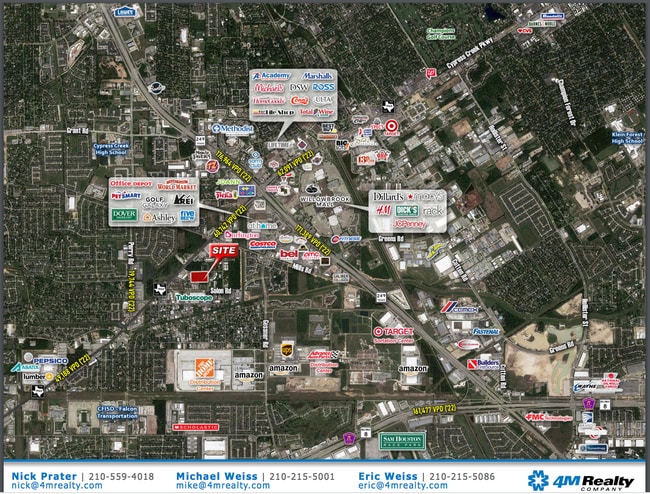

This Property Is For Sale
Property Detail
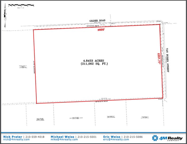
0 Gilder Rd
Houston-Pasadena-The Woodlands, TX
LTS 12 & 13 BELL MEAD
0861620000077
HARRIS
Commercialacreage
Texas
AE The base floodplain where base flood elevations are provided. AE Zones are now used on new format FIRMs instead of A1-A30 Zones.
12,13
2024
4.84 AC
2025
FM 1960/Hwy 249
534201
Houston
800 SF
NEARBY LISTINGS FOR SALE OR LEASE
DEMOGRAPHICS near 0 Gilder Rd
1 mile
3 mile
5 mile
2025 Total Population
13,511
95,239
300,465
2030 Population
14,393
101,172
317,840
Pop Growth 2025-2030
+ 6.53%
+ 6.23%
+ 5.78%
Average Age
35
38
38
2025 Total Households
4,813
35,612
108,328
HH Growth 2025-2030
+ 6.75%
+ 6.48%
+ 5.99%
Median Household Inc
$56,523
$69,573
$78,459
Avg Household Size
2.70
2.60
2.70
2025 Avg HH Vehicles
2.00
2.00
2.00
Median Home Value
$235,678
$267,283
$279,508
Median Year Built
2000
1994
1990
Nearby Places
Map Layers
Map Styles
 Street
 Aerial
Transit
 Traffic
 Biking
Places
Listings with unknown addresses are not visible on the map
- Restaurants
- Banks
- Shops
- Fitness
- Groceries
PUBLIC TRANSPORTATION
AIRPORT
George Bush Intcntl/Houston
Drive
Walk
Distance
George Bush Intcntl/Houston
24 min
17.3 mi
William P Hobby
Drive
Walk
Distance
William P Hobby
52 min
32.5 mi
Freight Ports
Port of Houston
Drive
Walk
Distance
Port of Houston
44 min
28.0 mi
Nearby Properties
Address
Land Use
TOTAL SIZE
Lot Size
Zoning
Address
Land Use
TOTAL SIZE
Lot Size
Zoning
587,609 SF
42.44 AC
Address
Land Use
TOTAL SIZE
Lot Size
Zoning
778,140 SF
40.25 AC
Address
Land Use
TOTAL SIZE
Lot Size
Zoning
427,317 SF
14.16 AC
Address
Land Use
TOTAL SIZE
Lot Size
Zoning
445,343 SF
37.78 AC
Address
Land Use
TOTAL SIZE
Lot Size
Zoning
660,000 SF
104.88 AC
Address
Land Use
TOTAL SIZE
Lot Size
Zoning
682,700 SF
37 AC
Address
Land Use
TOTAL SIZE
Lot Size
Zoning
227,400 SF
2.77 AC
Address
Land Use
TOTAL SIZE
Lot Size
Zoning
388,333 SF
41.17 AC
Address
Land Use
TOTAL SIZE
Lot Size
Zoning
386,754 SF
17.99 AC
Address
Land Use
TOTAL SIZE
Lot Size
Zoning
546,420 SF
40.07 AC
Address
Land Use
TOTAL SIZE
Lot Size
Zoning
527,744 SF
35.46 AC
Address
Land Use
TOTAL SIZE
Lot Size
Zoning
426,203 SF
23.88 AC
Address
Land Use
TOTAL SIZE
Lot Size
Zoning
301,119 SF
9.92 AC
Address
Land Use
TOTAL SIZE
Lot Size
Zoning
365,380 SF
19.17 AC
Address
Land Use
TOTAL SIZE
Lot Size
Zoning
551,524 SF
10.06 AC
Address
Land Use
TOTAL SIZE
Lot Size
Zoning
339,477 SF
13.54 AC
Address
Land Use
TOTAL SIZE
Lot Size
Zoning
495,024 SF
23.96 AC
Address
Land Use
TOTAL SIZE
Lot Size
Zoning
399,828 SF
20.32 AC
Address
Land Use
TOTAL SIZE
Lot Size
Zoning
267,094 SF
14.76 AC
Address
Land Use
TOTAL SIZE
Lot Size
Zoning
339,301 SF
68.40 AC
Address
Land Use
TOTAL SIZE
Lot Size
Zoning
365,711 SF
26.61 AC
Address
Land Use
TOTAL SIZE
Lot Size
Zoning
486,739 SF
19.92 AC
Address
Land Use
TOTAL SIZE
Lot Size
Zoning
405,225 SF
18.34 AC
Address
Land Use
TOTAL SIZE
Lot Size
Zoning
423,472 SF
28.91 AC
Address
Land Use
TOTAL SIZE
Lot Size
Zoning
361,800 SF
18.20 AC
Address
Land Use
TOTAL SIZE
Lot Size
Zoning
441,000 SF
23.07 AC
Address
Land Use
TOTAL SIZE
Lot Size
Zoning
469,370 SF
19.39 AC
Address
Land Use
TOTAL SIZE
Lot Size
Zoning
326,807 SF
29.43 AC
Address
Land Use
TOTAL SIZE
Lot Size
Zoning
433,984 SF
17.82 AC
Address
Land Use
TOTAL SIZE
Lot Size
Zoning
368,361 SF
23.95 AC
The World's #1 Commercial Real Estate Marketplace
Connect with us
© 2026 CoStar Group
The information above has been obtained from sources believed reliable. While we do not doubt its accuracy we have not verified it and make no guarantee, warranty or representation about it. It is your responsibility to independently confirm its accuracy and completeness. Any projections, opinions, assumptions, or estimates used are for example only and do not represent the current or future performance of the property. The value of this transaction to you depends on tax and other factors which should be evaluated by your tax, financial, and legal advisors. You and your advisors should conduct a careful, independent investigation of the property to determine to your satisfaction the suitability of the property for your needs.