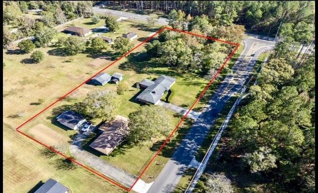
Property Record
Hemlock St, Jacksonville, FL 32218
Property Detail
Hemlock St
Jacksonville, FL
6-16 33-1N-26E .5 DAHLS ADDN TO GARDEN CITY LOTS 1 TO 9 BLK 18
019529-0005
DUVAL
Residentialacreage
Florida
RR-ACRE
1-9
2025
0.50 AC
2026
Northwest Jacksonville
010308
Jacksonville (Florida)
NEARBY LISTINGS FOR SALE OR LEASE
DEMOGRAPHICS near Hemlock St
1 mile
3 mile
5 mile
2025 Total Population
2,215
28,339
78,222
2030 Population
2,424
30,241
83,596
Pop Growth 2025-2030
+ 9.44%
+ 6.71%
+ 6.87%
Average Age
40
39
39
2025 Total Households
787
10,540
29,928
HH Growth 2025-2030
+ 9.91%
+ 6.93%
+ 7.18%
Median Household Inc
$73,437
$66,421
$59,863
Avg Household Size
2.70
2.60
2.60
2025 Avg HH Vehicles
2.00
2.00
2.00
Median Home Value
$353,265
$283,685
$243,605
Median Year Built
2007
1999
1988
Nearby Places
Map Layers
Map Styles
 Street
 Aerial
Transit
 Traffic
 Biking
Places
Listings with unknown addresses are not visible on the map
- Restaurants
- Banks
- Shops
- Fitness
- Groceries
PUBLIC TRANSPORTATION
COMMUTER RAIL
Jacksonville (Silver Meteor - Amtrak, Silver Star - Amtrak)
Drive
Walk
Distance
Jacksonville (Silver Meteor - Amtrak, Silver Star - Amtrak)
13 min
8.4 mi
AIRPORT
Jacksonville International
Drive
Walk
Distance
Jacksonville International
11 min
5.7 mi
Freight Ports
Jacksonville Port
Drive
Walk
Distance
Jacksonville Port
20 min
11.1 mi
SALE & LEASE HISTORY
LISTING DATE
SALE/LEASE

Nov 25, 2024
For Sale
Jul 29, 2025
For Sale
Jul 21, 2025
For Sale
Nearby Properties
Address
Land Use
TOTAL SIZE
Lot Size
Zoning
Address
Land Use
TOTAL SIZE
Lot Size
Zoning
2,999,392 SF
5,204.78 AC
PUD
Address
Land Use
TOTAL SIZE
Lot Size
Zoning
877,030 SF
135.59 AC
IBP
Address
Land Use
TOTAL SIZE
Lot Size
Zoning
658,743 SF
36.71 AC
PUD
Address
Land Use
TOTAL SIZE
Lot Size
Zoning
226,596 SF
13.23 AC
PUD
Address
Land Use
TOTAL SIZE
Lot Size
Zoning
556,924 SF
29.11 AC
PUD
Address
Land Use
TOTAL SIZE
Lot Size
Zoning
395,655 SF
21.86 AC
PUD
Address
Land Use
TOTAL SIZE
Lot Size
Zoning
284,023 SF
25.30 AC
RMD-C
Address
Land Use
TOTAL SIZE
Lot Size
Zoning
287,410 SF
43.31 AC
RMD-C
Address
Land Use
TOTAL SIZE
Lot Size
Zoning
214,742 SF
20.13 AC
PUD
Address
Land Use
TOTAL SIZE
Lot Size
Zoning
336,566 SF
25.63 AC
PUD
Address
Land Use
TOTAL SIZE
Lot Size
Zoning
6,300 SF
744.81 AC
PUD
Address
Land Use
TOTAL SIZE
Lot Size
Zoning
149,367 SF
810.98 AC
PUD
Address
Land Use
TOTAL SIZE
Lot Size
Zoning
254,693 SF
40.76 AC
RMD-D
Address
Land Use
TOTAL SIZE
Lot Size
Zoning
225,829 SF
140.47 AC
PBF-1
Address
Land Use
TOTAL SIZE
Lot Size
Zoning
39,251 SF
55.24 AC
PUD
Address
Land Use
TOTAL SIZE
Lot Size
Zoning
229,225 SF
15.98 AC
PUD
Address
Land Use
TOTAL SIZE
Lot Size
Zoning
104,322 SF
5.20 AC
PBF-3
Address
Land Use
TOTAL SIZE
Lot Size
Zoning
57,495 SF
1.95 AC
CCG-1
Address
Land Use
TOTAL SIZE
Lot Size
Zoning
157.33 AC
PUD
Address
Land Use
TOTAL SIZE
Lot Size
Zoning
240,692 SF
30.32 AC
CCG-1
Address
Land Use
TOTAL SIZE
Lot Size
Zoning
130,885 SF
8.37 AC
RMD-D
Address
Land Use
TOTAL SIZE
Lot Size
Zoning
138,588 SF
9.51 AC
PUD
Address
Land Use
TOTAL SIZE
Lot Size
Zoning
238,052 SF
30.81 AC
RHD-A
Address
Land Use
TOTAL SIZE
Lot Size
Zoning
124,680 SF
7.21 AC
CCG-1
Address
Land Use
TOTAL SIZE
Lot Size
Zoning
94,300 SF
7.65 AC
PUD
Address
Land Use
TOTAL SIZE
Lot Size
Zoning
82,610 SF
9.46 AC
PBF-2
Address
Land Use
TOTAL SIZE
Lot Size
Zoning
9,238 SF
48.79 AC
ROS
Address
Land Use
TOTAL SIZE
Lot Size
Zoning
120,601 SF
7.57 AC
PUD
Address
Land Use
TOTAL SIZE
Lot Size
Zoning
37,595 SF
14.09 AC
IL
Address
Land Use
TOTAL SIZE
Lot Size
Zoning
80,905 SF
14.86 AC
PUD
The World's #1 Commercial Real Estate Marketplace
Connect with us
© 2026 CoStar Group
The information above has been obtained from sources believed reliable. While we do not doubt its accuracy we have not verified it and make no guarantee, warranty or representation about it. It is your responsibility to independently confirm its accuracy and completeness. Any projections, opinions, assumptions, or estimates used are for example only and do not represent the current or future performance of the property. The value of this transaction to you depends on tax and other factors which should be evaluated by your tax, financial, and legal advisors. You and your advisors should conduct a careful, independent investigation of the property to determine to your satisfaction the suitability of the property for your needs.