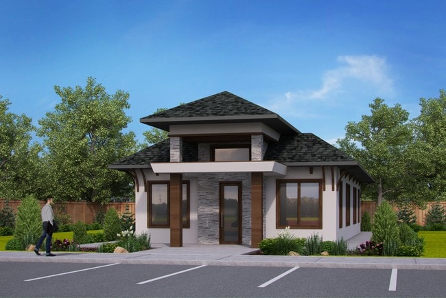
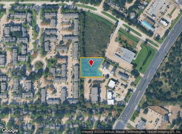
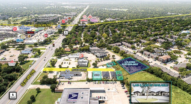
Property Record
0 Highway 6 N, Houston, TX 77095

NEARBY LISTINGS FOR SALE OR LEASE
Property Detail
0 Highway 6 N
Houston-Pasadena-The Woodlands, TX
Point Northwest Sec 1
1153420020013
RES C3-A BLK 2 POINT NORTHWEST SEC 1
Commercialacreage
Harris
X
Texas
48201C0420P
1.22 AC
2024
FM 1960/Hwy 249
2025
Houston
541100
DEMOGRAPHICS near 0 Highway 6 N
1 Mile
3 Mile
5 Mile
2024 Total Population
18,091
117,403
307,630
2029 Population
18,258
118,589
311,078
Pop Growth 2024-2029
+ 0.92%
+ 1.01%
+ 1.12%
Average Age
36
37
37
2024 Total Households
7,085
42,034
104,533
HH Growth 2024-2029
+ 0.89%
+ 0.97%
+ 1.07%
Median Household Inc
$69,008
$77,744
$82,036
Avg Household Size
2.50
2.70
2.90
2024 Avg HH Vehicles
2.00
2.00
2.00
Median Home Value
$240,776
$236,771
$241,466
Median Year Built
1992
1993
1995
Nearby Places
Map Layers
Map Styles
 Street
 Aerial
- Restaurants
- Banks
- Shops
- Fitness
- Groceries
PUBLIC TRANSPORTATION
AIRPORT
George Bush Intcntl/Houston
DRIVE
WALK
Distance
George Bush Intcntl/Houston
32 min
22.6 mi
William P Hobby
DRIVE
WALK
Distance
William P Hobby
54 min
35.6 mi
Freight Ports
Port of Houston
DRIVE
WALK
Distance
Port of Houston
45 min
31.2 mi
SALE & LEASE HISTORY
LISTING DATE
SALE/LEASE

Sep 19, 2023
For Lease
Sep 19, 2023
For Sale
Oct 07, 2020
For Sale
May 17, 2017
For Sale
Nearby Properties
Address
Land Use
TOTAL SIZE
Lot Size
Zoning
Address
Land Use
TOTAL SIZE
Lot Size
Zoning
311,285 SF
14.47 AC
Address
Land Use
TOTAL SIZE
Lot Size
Zoning
625,701 SF
52.20 AC
Address
Land Use
TOTAL SIZE
Lot Size
Zoning
697,158 SF
Address
Land Use
TOTAL SIZE
Lot Size
Zoning
664,361 SF
39.18 AC
Address
Land Use
TOTAL SIZE
Lot Size
Zoning
386,642 SF
14.45 AC
Address
Land Use
TOTAL SIZE
Lot Size
Zoning
466,299 SF
23.82 AC
Address
Land Use
TOTAL SIZE
Lot Size
Zoning
120.78 AC
Address
Land Use
TOTAL SIZE
Lot Size
Zoning
560,725 SF
31.41 AC
Address
Land Use
TOTAL SIZE
Lot Size
Zoning
373,516 SF
18.63 AC
Address
Land Use
TOTAL SIZE
Lot Size
Zoning
1,353,057 SF
224.60 AC
Address
Land Use
TOTAL SIZE
Lot Size
Zoning
266,802 SF
3.14 AC
Address
Land Use
TOTAL SIZE
Lot Size
Zoning
408,710 SF
4.49 AC
Address
Land Use
TOTAL SIZE
Lot Size
Zoning
358,713 SF
19.91 AC
Address
Land Use
TOTAL SIZE
Lot Size
Zoning
307,960 SF
31.75 AC
Address
Land Use
TOTAL SIZE
Lot Size
Zoning
471,800 SF
27.03 AC
Address
Land Use
TOTAL SIZE
Lot Size
Zoning
55.82 AC
Address
Land Use
TOTAL SIZE
Lot Size
Zoning
307,698 SF
13.12 AC
Address
Land Use
TOTAL SIZE
Lot Size
Zoning
449,032 SF
23.46 AC
Address
Land Use
TOTAL SIZE
Lot Size
Zoning
387,245 SF
18.18 AC
Address
Land Use
TOTAL SIZE
Lot Size
Zoning
151,314 SF
3.88 AC
Address
Land Use
TOTAL SIZE
Lot Size
Zoning
408,144 SF
26.13 AC
Address
Land Use
TOTAL SIZE
Lot Size
Zoning
392,185 SF
30.73 AC
Address
Land Use
TOTAL SIZE
Lot Size
Zoning
399,729 SF
20.15 AC
Address
Land Use
TOTAL SIZE
Lot Size
Zoning
402,712 SF
25.64 AC
Address
Land Use
TOTAL SIZE
Lot Size
Zoning
375,251 SF
14.85 AC
Address
Land Use
TOTAL SIZE
Lot Size
Zoning
401,107 SF
33.90 AC
Address
Land Use
TOTAL SIZE
Lot Size
Zoning
463,932 SF
26.62 AC
Address
Land Use
TOTAL SIZE
Lot Size
Zoning
388,223 SF
14.99 AC
Address
Land Use
TOTAL SIZE
Lot Size
Zoning
384,280 SF
27.19 AC
Address
Land Use
TOTAL SIZE
Lot Size
Zoning
363,896 SF
21.69 AC
The World's #1 Commercial Real Estate Marketplace
Connect with us
© 2026 CoStar Group
The information above has been obtained from sources believed reliable. While we do not doubt its accuracy we have not verified it and make no guarantee, warranty or representation about it. It is your responsibility to independently confirm its accuracy and completeness. Any projections, opinions, assumptions, or estimates used are for example only and do not represent the current or future performance of the property. The value of this transaction to you depends on tax and other factors which should be evaluated by your tax, financial, and legal advisors. You and your advisors should conduct a careful, independent investigation of the property to determine to your satisfaction the suitability of the property for your needs.