Property Record
Banks Rd E, Fayetteville, GA 30214
This Property Is For Sale
NEARBY LISTINGS FOR SALE OR LEASE
-
-
-
-
-
-
Jimmie Mayfield Blvd Fayetteville, GA 30215 United States
Fayetteville, GA 30215
$10,000,000
28.60 AC Lots
Land
-
-
View all Fayetteville listings for sale on LoopNet.com
Property Detail
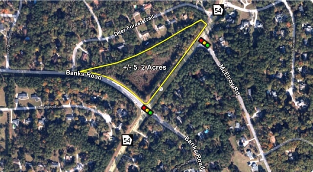
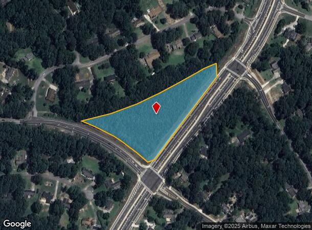
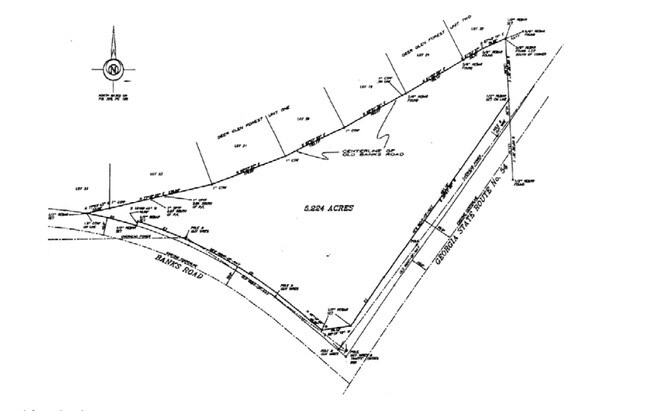
Banks Rd E
Atlanta-Sandy Springs-Roswell, GA
Fayette
05-32-00-023
Georgia
Residentialnec
4.86 AC
X
Fayette/Coweta County
13113C0108E
Atlanta
DEMOGRAPHICS near Banks Rd E
1 Mile
3 Mile
5 Mile
2024 Total Population
1,836
31,081
109,415
2029 Population
1,956
32,146
111,562
Pop Growth 2024-2029
+ 6.54%
+ 3.43%
+ 1.96%
Average Age
42
40
39
2024 Total Households
662
11,259
38,155
HH Growth 2024-2029
+ 6.65%
+ 3.61%
+ 2.07%
Median Household Inc
$65,535
$64,732
$69,271
Avg Household Size
2.70
2.70
2.80
2024 Avg HH Vehicles
2.00
2.00
2.00
Median Home Value
$265,296
$237,140
$231,132
Median Year Built
1985
1991
1991
Nearby Places
- Restaurants
- Banks
- Shops
- Fitness
- Groceries
PUBLIC TRANSPORTATION
AIRPORT
Hartsfield - Jackson Atlanta International
DRIVE
WALK
Distance
Hartsfield - Jackson Atlanta International
28 min
14.9 mi
Freight Ports
Georgia Ports - Savannah
DRIVE
WALK
Distance
Georgia Ports - Savannah
269 min
235.9 mi
Nearby Properties
Address
Land Use
TOTAL SIZE
Lot Size
Zoning
Address
Land Use
TOTAL SIZE
Lot Size
Zoning
224,116 SF
41.20 AC
MUC
Address
Land Use
TOTAL SIZE
Lot Size
Zoning
197,026 SF
28 AC
Address
Land Use
TOTAL SIZE
Lot Size
Zoning
7,851 SF
94.84 AC
RS180
Address
Land Use
TOTAL SIZE
Lot Size
Zoning
88,509 SF
31.54 AC
C C3
Address
Land Use
TOTAL SIZE
Lot Size
Zoning
80,942 SF
44.16 AC
C CH
Address
Land Use
TOTAL SIZE
Lot Size
Zoning
232,852 SF
35.39 AC
C C3
Address
Land Use
TOTAL SIZE
Lot Size
Zoning
158,310 SF
4.76 AC
C C1
Address
Land Use
TOTAL SIZE
Lot Size
Zoning
260,883 SF
21.30 AC
C C3
Address
Land Use
TOTAL SIZE
Lot Size
Zoning
111,198 SF
8.94 AC
C C1
Address
Land Use
TOTAL SIZE
Lot Size
Zoning
611 SF
155.70 AC
RMH
Address
Land Use
TOTAL SIZE
Lot Size
Zoning
92,550 SF
10.70 AC
C C1
Address
Land Use
TOTAL SIZE
Lot Size
Zoning
120,793 SF
5.60 AC
C PUD
Address
Land Use
TOTAL SIZE
Lot Size
Zoning
112,650 SF
22.78 AC
C RMF15
Address
Land Use
TOTAL SIZE
Lot Size
Zoning
132,197 SF
18 AC
C RMF15
Address
Land Use
TOTAL SIZE
Lot Size
Zoning
220,887 SF
24.70 AC
Address
Land Use
TOTAL SIZE
Lot Size
Zoning
35,356 SF
2.01 AC
C C1
Address
Land Use
TOTAL SIZE
Lot Size
Zoning
300 SF
55.60 AC
RMH
Address
Land Use
TOTAL SIZE
Lot Size
Zoning
210,122 SF
16.77 AC
C C3
Address
Land Use
TOTAL SIZE
Lot Size
Zoning
184,862 SF
21.90 AC
C C3
Address
Land Use
TOTAL SIZE
Lot Size
Zoning
127,836 SF
14.33 AC
C CH
Address
Land Use
TOTAL SIZE
Lot Size
Zoning
135,115 SF
32.15 AC
Address
Land Use
TOTAL SIZE
Lot Size
Zoning
199,132 SF
19.59 AC
C PUD
Address
Land Use
TOTAL SIZE
Lot Size
Zoning
136,320 SF
19.51 AC
C C3
Address
Land Use
TOTAL SIZE
Lot Size
Zoning
75,043 SF
3.20 AC
HC
Address
Land Use
TOTAL SIZE
Lot Size
Zoning
65,951 SF
6.70 AC
C C3
Address
Land Use
TOTAL SIZE
Lot Size
Zoning
75,750 SF
10.43 AC
C C3
Address
Land Use
TOTAL SIZE
Lot Size
Zoning
67,801 SF
14 AC
TR
Address
Land Use
TOTAL SIZE
Lot Size
Zoning
73,040 SF
6.01 AC
C RMF15
Address
Land Use
TOTAL SIZE
Lot Size
Zoning
102,653 SF
5.50 AC
ER
Address
Land Use
TOTAL SIZE
Lot Size
Zoning
25,980 SF
199.40 AC
The World's #1 Commercial Real Estate Marketplace
Connect with us
© 2025 CoStar Group
The information above has been obtained from sources believed reliable. While we do not doubt its accuracy we have not verified it and make no guarantee, warranty or representation about it. It is your responsibility to independently confirm its accuracy and completeness. Any projections, opinions, assumptions, or estimates used are for example only and do not represent the current or future performance of the property. The value of this transaction to you depends on tax and other factors which should be evaluated by your tax, financial, and legal advisors. You and your advisors should conduct a careful, independent investigation of the property to determine to your satisfaction the suitability of the property for your needs.