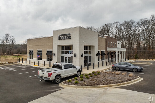
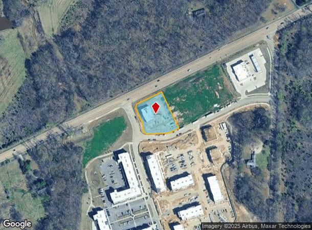
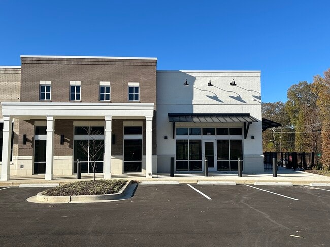
Property Record
9775 Highway 70, Arlington, TN 38002
NEARBY LISTINGS FOR SALE OR LEASE
Property Detail
9775 Highway 70
Memphis, TN-MS-AR
Lakeland Town Center Pmud
L0-150-0-0550
US HIGHWAY 70 COR VILLAGE LANE (SE) SEE MAP PAGE 76
Storebuilding
Shelby
X
Tennessee
47157C0215G
4
2023
1.02 AC
2025
Northeast
020836
Memphis
5,622 SF
DEMOGRAPHICS near 9775 Highway 70
1 Mile
3 Mile
5 Mile
2024 Total Population
1,244
13,421
48,931
2029 Population
1,228
13,053
47,490
Pop Growth 2024-2029
(1.29%)
(2.74%)
(2.94%)
Average Age
38
39
38
2024 Total Households
389
4,365
17,241
HH Growth 2024-2029
(1.54%)
(2.93%)
(3.09%)
Median Household Inc
$147,413
$133,605
$95,550
Avg Household Size
3.10
3.00
2.80
2024 Avg HH Vehicles
3.00
3.00
2.00
Median Home Value
$443,157
$372,239
$299,235
Median Year Built
2006
2001
1999
Nearby Places
- Restaurants
- Banks
- Shops
- Fitness
- Groceries
PUBLIC TRANSPORTATION
AIRPORT
Memphis International
DRIVE
WALK
Distance
Memphis International
38 min
26.3 mi
Freight Ports
Port of Shreveport
DRIVE
WALK
Distance
Port of Shreveport
429 min
390.4 mi
SALE & LEASE HISTORY
LISTING DATE
SALE/LEASE

Aug 13, 2020
For Lease
Nearby Properties
Address
Land Use
TOTAL SIZE
Lot Size
Zoning
Address
Land Use
TOTAL SIZE
Lot Size
Zoning
129,662 SF
10.25 AC
CA
Address
Land Use
TOTAL SIZE
Lot Size
Zoning
68,940 SF
8.78 AC
CA
Address
Land Use
TOTAL SIZE
Lot Size
Zoning
94,022 SF
114.02 AC
C-2
Address
Land Use
TOTAL SIZE
Lot Size
Zoning
20,056 SF
20.76 AC
R-E
Address
Land Use
TOTAL SIZE
Lot Size
Zoning
170 AC
RS-6
Address
Land Use
TOTAL SIZE
Lot Size
Zoning
324.75 AC
RS-6
Address
Land Use
TOTAL SIZE
Lot Size
Zoning
100.29 AC
AG
Address
Land Use
TOTAL SIZE
Lot Size
Zoning
8,359 SF
1.67 AC
CA
Address
Land Use
TOTAL SIZE
Lot Size
Zoning
5,363 SF
2.53 AC
C-2
Address
Land Use
TOTAL SIZE
Lot Size
Zoning
5,668 SF
72.20 AC
AG
Address
Land Use
TOTAL SIZE
Lot Size
Zoning
96.48 AC
AG
Address
Land Use
TOTAL SIZE
Lot Size
Zoning
9,900 SF
13.25 AC
CA
Address
Land Use
TOTAL SIZE
Lot Size
Zoning
20,605 SF
2.68 AC
S-C
Address
Land Use
TOTAL SIZE
Lot Size
Zoning
5.83 AC
E
Address
Land Use
TOTAL SIZE
Lot Size
Zoning
10,108 SF
2.17 AC
CA
Address
Land Use
TOTAL SIZE
Lot Size
Zoning
8,134 SF
2.50 AC
B-2
Address
Land Use
TOTAL SIZE
Lot Size
Zoning
11,200 SF
66.47 AC
CA
Address
Land Use
TOTAL SIZE
Lot Size
Zoning
9,200 SF
1.19 AC
R-E
Address
Land Use
TOTAL SIZE
Lot Size
Zoning
10,062 SF
2.80 AC
C-2
Address
Land Use
TOTAL SIZE
Lot Size
Zoning
13,760 SF
1.35 AC
C-2
Address
Land Use
TOTAL SIZE
Lot Size
Zoning
665.93 AC
AG
Address
Land Use
TOTAL SIZE
Lot Size
Zoning
206.19 AC
AG
Address
Land Use
TOTAL SIZE
Lot Size
Zoning
6,768 SF
1.18 AC
C-2
Address
Land Use
TOTAL SIZE
Lot Size
Zoning
240.80 AC
AG
Address
Land Use
TOTAL SIZE
Lot Size
Zoning
12,804 SF
1.35 AC
C-2
Address
Land Use
TOTAL SIZE
Lot Size
Zoning
16,640 SF
182.54 AC
I-L
Address
Land Use
TOTAL SIZE
Lot Size
Zoning
17,740 SF
4.69 AC
EMP
Address
Land Use
TOTAL SIZE
Lot Size
Zoning
5.96 AC
B-2
Address
Land Use
TOTAL SIZE
Lot Size
Zoning
40,632 SF
4.91 AC
C-2
The World's #1 Commercial Real Estate Marketplace
Connect with us
© 2025 CoStar Group
The information above has been obtained from sources believed reliable. While we do not doubt its accuracy we have not verified it and make no guarantee, warranty or representation about it. It is your responsibility to independently confirm its accuracy and completeness. Any projections, opinions, assumptions, or estimates used are for example only and do not represent the current or future performance of the property. The value of this transaction to you depends on tax and other factors which should be evaluated by your tax, financial, and legal advisors. You and your advisors should conduct a careful, independent investigation of the property to determine to your satisfaction the suitability of the property for your needs.