Property Record
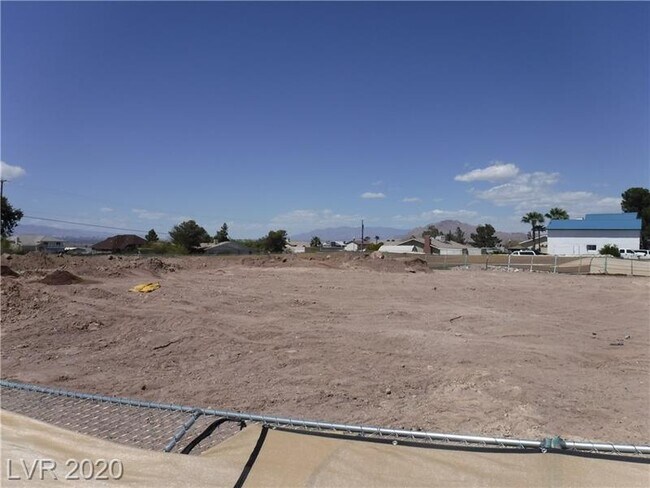
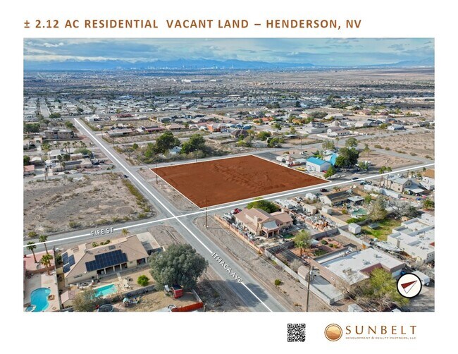
246 Whitewater Falls Ct, Henderson, NV 89015

Property Detail
246 Whitewater Falls Ct
179-04-407-009
PT SE4 SW4 SEC 04 22 63
Vacantlandnec
CLARK
RS2
Nevada
C and X Area of minimal flood hazard, usually depicted on FIRMs as above the 500-year flood level.
2.12 AC
2026
SE Las Vegas/Henderson
2026
Las Vegas
005422
Las Vegas-Henderson-North Las Vegas, NV
NEARBY LISTINGS FOR SALE OR LEASE
DEMOGRAPHICS near 246 Whitewater Falls Ct
1 mile
3 mile
5 mile
2025 Total Population
10,229
64,199
154,249
2030 Population
10,888
69,051
163,974
Pop Growth 2025-2030
+ 6.44%
+ 7.56%
+ 6.30%
Average Age
42
42
41
2025 Total Households
3,651
24,502
58,800
HH Growth 2025-2030
+ 6.55%
+ 7.69%
+ 6.45%
Median Household Inc
$70,158
$85,114
$90,512
Avg Household Size
2.60
2.50
2.50
2025 Avg HH Vehicles
2.00
2.00
2.00
Median Home Value
$442,665
$461,231
$459,487
Median Year Built
1994
2000
2001
Nearby Places
Map Layers
Map Styles
 Street
 Aerial
Layers
 Traffic
 Biking
Places
Listings with unknown addresses are not visible on the map
- Restaurants
- Banks
- Shops
- Fitness
- Groceries
PUBLIC TRANSPORTATION
AIRPORT
Boulder City Municipal
Drive
Walk
Distance
Boulder City Municipal
22 min
11.7 mi
Harry Reid International
Drive
Walk
Distance
Harry Reid International
24 min
15.7 mi
Freight Ports
Port of Long Beach
Drive
Walk
Distance
Port of Long Beach
321 min
284.3 mi
SALE & LEASE HISTORY
LISTING DATE
SALE/LEASE

Feb 10, 2021
For Sale
Apr 02, 2024
For Sale
Nearby Properties
Address
Land Use
TOTAL SIZE
Lot Size
Zoning
Address
Land Use
TOTAL SIZE
Lot Size
Zoning
100 SF
320 AC
DH
Address
Land Use
TOTAL SIZE
Lot Size
Zoning
Address
Land Use
TOTAL SIZE
Lot Size
Zoning
31,463 SF
191.46 AC
PS
Address
Land Use
TOTAL SIZE
Lot Size
Zoning
502,625 SF
45.92 AC
Address
Land Use
TOTAL SIZE
Lot Size
Zoning
9,493 SF
15.37 AC
Address
Land Use
TOTAL SIZE
Lot Size
Zoning
350.47 AC
PS
Address
Land Use
TOTAL SIZE
Lot Size
Zoning
10.50 AC
Address
Land Use
TOTAL SIZE
Lot Size
Zoning
81,485 SF
160.06 AC
PS
Address
Land Use
TOTAL SIZE
Lot Size
Zoning
387,990 SF
22.04 AC
Address
Land Use
TOTAL SIZE
Lot Size
Zoning
9,000 SF
96.81 AC
RE
Address
Land Use
TOTAL SIZE
Lot Size
Zoning
40,031 SF
21.25 AC
Address
Land Use
TOTAL SIZE
Lot Size
Zoning
78,760 SF
1.23 AC
Address
Land Use
TOTAL SIZE
Lot Size
Zoning
71,133 SF
7.56 AC
DP
Address
Land Use
TOTAL SIZE
Lot Size
Zoning
19,753 SF
10.21 AC
DP
Address
Land Use
TOTAL SIZE
Lot Size
Zoning
213,472 SF
7.46 AC
Address
Land Use
TOTAL SIZE
Lot Size
Zoning
3,664 SF
16.09 AC
RH20
Address
Land Use
TOTAL SIZE
Lot Size
Zoning
14,463 SF
19.48 AC
Address
Land Use
TOTAL SIZE
Lot Size
Zoning
136,465 SF
34.67 AC
Address
Land Use
TOTAL SIZE
Lot Size
Zoning
168,361 SF
10.84 AC
Address
Land Use
TOTAL SIZE
Lot Size
Zoning
320 AC
PS
Address
Land Use
TOTAL SIZE
Lot Size
Zoning
292,375 SF
39.22 AC
M2
Address
Land Use
TOTAL SIZE
Lot Size
Zoning
4,148 SF
4.38 AC
MC
Address
Land Use
TOTAL SIZE
Lot Size
Zoning
320 AC
DH
Address
Land Use
TOTAL SIZE
Lot Size
Zoning
170,646 SF
18.16 AC
H:IG-RD
Address
Land Use
TOTAL SIZE
Lot Size
Zoning
498,519 SF
113.66 AC
Address
Land Use
TOTAL SIZE
Lot Size
Zoning
3,085 SF
2.51 AC
Address
Land Use
TOTAL SIZE
Lot Size
Zoning
124,900 SF
5.45 AC
Address
Land Use
TOTAL SIZE
Lot Size
Zoning
83,313 SF
7.79 AC
The World's #1 Commercial Real Estate Marketplace
Connect with us
© 2026 CoStar Group
The information above has been obtained from sources believed reliable. While we do not doubt its accuracy we have not verified it and make no guarantee, warranty or representation about it. It is your responsibility to independently confirm its accuracy and completeness. Any projections, opinions, assumptions, or estimates used are for example only and do not represent the current or future performance of the property. The value of this transaction to you depends on tax and other factors which should be evaluated by your tax, financial, and legal advisors. You and your advisors should conduct a careful, independent investigation of the property to determine to your satisfaction the suitability of the property for your needs.