Property Record
Ivanhoe Rd, Oakland, CA 94618


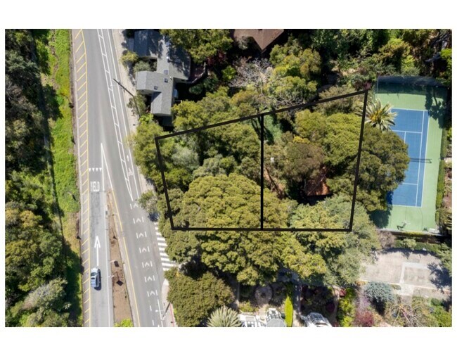


Property Detail
Ivanhoe Rd
Oakland-Fremont-Berkeley, CA
LOT: 0000A BLK: PM: 0094 PAGE: 0088 ;LOT: 0000B BLK: PM: 0094 PAGE: 0088 ;LOT: 0000C BLK: PM: 0094 PAGE: 0088
048A-7060-017-01
ALAMEDA
Recreationalacreage
California
B and X Area of moderate flood hazard, usually the area between the limits of the 100-year and 500-year floods.
0.12 AC
2024
Oakland-North
2025
East Bay/Oakland
404300
NEARBY LISTINGS FOR SALE OR LEASE
DEMOGRAPHICS near Ivanhoe Rd
1 mile
3 mile
5 mile
2025 Total Population
25,669
255,239
482,015
2030 Population
25,704
256,352
483,786
Pop Growth 2025-2030
+ 0.14%
+ 0.44%
+ 0.37%
Average Age
43
40
41
2025 Total Households
11,145
108,108
197,389
HH Growth 2025-2030
+ 0.05%
+ 0.54%
+ 0.48%
Median Household Inc
$170,716
$116,026
$110,455
Avg Household Size
2.20
2.10
2.20
2025 Avg HH Vehicles
2.00
1.00
1.00
Median Home Value
$1,126,361
$1,087,618
$1,068,663
Median Year Built
1947
1955
1955
Nearby Places
Map Layers
Map Styles
 Street
 Aerial
Layers
 Traffic
 Biking
Places
Listings with unknown addresses are not visible on the map
- Restaurants
- Banks
- Shops
- Fitness
- Groceries
PUBLIC TRANSPORTATION
TRANSIT/SUBWAY
Rockridge Station (Pittsburg/Bay Point - San Francisco International - Bay Area Rapid Transit (BART))
Drive
Walk
Distance
Rockridge Station (Pittsburg/Bay Point - San Francisco International - Bay Area Rapid Transit (BART))
1 min
6 min
0.3 mi
COMMUTER RAIL
Drive
Walk
Distance
10 min
3.7 mi
Drive
Walk
Distance
9 min
5.0 mi
AIRPORT
Metro Oakland International
Drive
Walk
Distance
Metro Oakland International
20 min
13.7 mi
San Francisco International
Drive
Walk
Distance
San Francisco International
37 min
23.8 mi
SALE & LEASE HISTORY
LISTING DATE
SALE/LEASE

May 01, 2024
For Sale
Nearby Properties
Address
Land Use
TOTAL SIZE
Lot Size
Zoning
Address
Land Use
TOTAL SIZE
Lot Size
Zoning
409,266 SF
1.76 AC
Address
Land Use
TOTAL SIZE
Lot Size
Zoning
1,028,501 SF
2.74 AC
Address
Land Use
TOTAL SIZE
Lot Size
Zoning
373,594 SF
16.16 AC
Address
Land Use
TOTAL SIZE
Lot Size
Zoning
488,781 SF
0.63 AC
Address
Land Use
TOTAL SIZE
Lot Size
Zoning
490,000 SF
1.44 AC
Address
Land Use
TOTAL SIZE
Lot Size
Zoning
432,352 SF
Address
Land Use
TOTAL SIZE
Lot Size
Zoning
354,263 SF
4.06 AC
Address
Land Use
TOTAL SIZE
Lot Size
Zoning
358,014 SF
5.03 AC
Address
Land Use
TOTAL SIZE
Lot Size
Zoning
423,577 SF
1.04 AC
Address
Land Use
TOTAL SIZE
Lot Size
Zoning
167,071 SF
0.70 AC
Address
Land Use
TOTAL SIZE
Lot Size
Zoning
540,434 SF
14.37 AC
Address
Land Use
TOTAL SIZE
Lot Size
Zoning
621,432 SF
1.31 AC
C
Address
Land Use
TOTAL SIZE
Lot Size
Zoning
288,796 SF
0.52 AC
Address
Land Use
TOTAL SIZE
Lot Size
Zoning
395,549 SF
17.05 AC
Address
Land Use
TOTAL SIZE
Lot Size
Zoning
250,642 SF
17.05 AC
Address
Land Use
TOTAL SIZE
Lot Size
Zoning
0.73 AC
Address
Land Use
TOTAL SIZE
Lot Size
Zoning
703,758 SF
3.44 AC
Address
Land Use
TOTAL SIZE
Lot Size
Zoning
371,322 SF
1.62 AC
Address
Land Use
TOTAL SIZE
Lot Size
Zoning
240,633 SF
1.59 AC
Address
Land Use
TOTAL SIZE
Lot Size
Zoning
261,134 SF
2.23 AC
Address
Land Use
TOTAL SIZE
Lot Size
Zoning
350,741 SF
1.08 AC
Address
Land Use
TOTAL SIZE
Lot Size
Zoning
169,157 SF
10.20 AC
Address
Land Use
TOTAL SIZE
Lot Size
Zoning
224,160 SF
5.03 AC
Address
Land Use
TOTAL SIZE
Lot Size
Zoning
245,717 SF
0.65 AC
Address
Land Use
TOTAL SIZE
Lot Size
Zoning
303,063 SF
1.27 AC
Address
Land Use
TOTAL SIZE
Lot Size
Zoning
226,800 SF
4.63 AC
Address
Land Use
TOTAL SIZE
Lot Size
Zoning
177,530 SF
0.46 AC
Address
Land Use
TOTAL SIZE
Lot Size
Zoning
280,484 SF
0.76 AC
Address
Land Use
TOTAL SIZE
Lot Size
Zoning
292,430 SF
2.09 AC
Address
Land Use
TOTAL SIZE
Lot Size
Zoning
397,378 SF
4.52 AC
The World's #1 Commercial Real Estate Marketplace
Connect with us
© 2026 CoStar Group
The information above has been obtained from sources believed reliable. While we do not doubt its accuracy we have not verified it and make no guarantee, warranty or representation about it. It is your responsibility to independently confirm its accuracy and completeness. Any projections, opinions, assumptions, or estimates used are for example only and do not represent the current or future performance of the property. The value of this transaction to you depends on tax and other factors which should be evaluated by your tax, financial, and legal advisors. You and your advisors should conduct a careful, independent investigation of the property to determine to your satisfaction the suitability of the property for your needs.