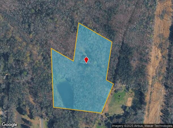
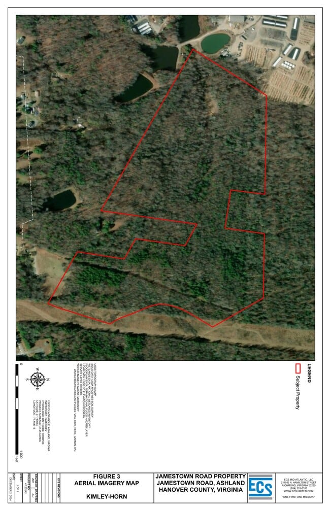
Property Record
10212 Jamestown Rd, Ashland, VA 23005
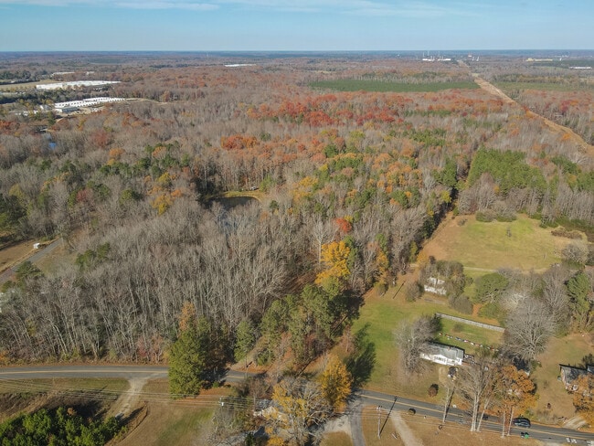

This Property Is For Sale
NEARBY LISTINGS FOR SALE OR LEASE
Property Detail
10212 Jamestown Rd
Richmond, VA
Hanover
7880-58-6479
Virginia
Sfr
12.54 AC
X
I-95 North/Chamberlayne
51085C0189C
Richmond VA
3,413 SF
DEMOGRAPHICS near 10212 Jamestown Rd
1 Mile
3 Mile
5 Mile
2024 Total Population
603
12,172
17,232
2029 Population
686
13,802
19,562
Pop Growth 2024-2029
+ 13.76%
+ 13.39%
+ 13.52%
Average Age
39
40
41
2024 Total Households
221
4,498
6,435
HH Growth 2024-2029
+ 14.03%
+ 14.03%
+ 14.11%
Median Household Inc
$106,465
$69,371
$74,203
Avg Household Size
2.70
2.40
2.50
2024 Avg HH Vehicles
2.00
2.00
2.00
Median Home Value
$432,000
$311,913
$339,942
Median Year Built
1995
1984
1986
Nearby Places
Map Layers
Map Styles
 Street
 Aerial
- Restaurants
- Banks
- Shops
- Fitness
- Groceries
PUBLIC TRANSPORTATION
COMMUTER RAIL
Ashland Amtrak (Northeast Regional - Amtrak)
DRIVE
WALK
Distance
Ashland Amtrak (Northeast Regional - Amtrak)
6 min
2.5 mi
AIRPORT
Richmond International
DRIVE
WALK
Distance
Richmond International
37 min
26.3 mi
Freight Ports
Virginia Port Authority - Richmond
DRIVE
WALK
Distance
Virginia Port Authority - Richmond
38 min
25.9 mi
Nearby Properties
Address
Land Use
TOTAL SIZE
Lot Size
Zoning
Address
Land Use
TOTAL SIZE
Lot Size
Zoning
36.08 AC
HE
Address
Land Use
TOTAL SIZE
Lot Size
Zoning
189.83 AC
M-2
Address
Land Use
TOTAL SIZE
Lot Size
Zoning
26,583 SF
9 AC
HE
Address
Land Use
TOTAL SIZE
Lot Size
Zoning
538,610 SF
545.15 AC
M-3
Address
Land Use
TOTAL SIZE
Lot Size
Zoning
3.60 AC
HE
Address
Land Use
TOTAL SIZE
Lot Size
Zoning
194,598 SF
14.50 AC
R-5
Address
Land Use
TOTAL SIZE
Lot Size
Zoning
311,740 SF
43.40 AC
M-1
Address
Land Use
TOTAL SIZE
Lot Size
Zoning
280,900 SF
22.69 AC
M-1
Address
Land Use
TOTAL SIZE
Lot Size
Zoning
220,499 SF
19.01 AC
PSC
Address
Land Use
TOTAL SIZE
Lot Size
Zoning
24.21 AC
RR-1
Address
Land Use
TOTAL SIZE
Lot Size
Zoning
43.11 AC
PMH
Address
Land Use
TOTAL SIZE
Lot Size
Zoning
10.50 AC
R-2
Address
Land Use
TOTAL SIZE
Lot Size
Zoning
151,540 SF
21.15 AC
PSC
Address
Land Use
TOTAL SIZE
Lot Size
Zoning
23.97 AC
RR-1
Address
Land Use
TOTAL SIZE
Lot Size
Zoning
66,910 SF
1.94 AC
B-2
Address
Land Use
TOTAL SIZE
Lot Size
Zoning
48,622 SF
24.28 AC
POB
Address
Land Use
TOTAL SIZE
Lot Size
Zoning
65,670 SF
5.97 AC
R-5
Address
Land Use
TOTAL SIZE
Lot Size
Zoning
1.77 AC
B-2
Address
Land Use
TOTAL SIZE
Lot Size
Zoning
5 AC
HE
Address
Land Use
TOTAL SIZE
Lot Size
Zoning
38,738 SF
2.38 AC
B-2
Address
Land Use
TOTAL SIZE
Lot Size
Zoning
70,128 SF
5.11 AC
R-5
Address
Land Use
TOTAL SIZE
Lot Size
Zoning
70,128 SF
5.32 AC
R-5
Address
Land Use
TOTAL SIZE
Lot Size
Zoning
81,066 SF
15 AC
M-1
Address
Land Use
TOTAL SIZE
Lot Size
Zoning
81,255 SF
13.48 AC
M-1
Address
Land Use
TOTAL SIZE
Lot Size
Zoning
41,515 SF
4.13 AC
M-1
Address
Land Use
TOTAL SIZE
Lot Size
Zoning
54,460 SF
4.72 AC
B-4
Address
Land Use
TOTAL SIZE
Lot Size
Zoning
216,700 SF
11.22 AC
M-2
Address
Land Use
TOTAL SIZE
Lot Size
Zoning
92,400 SF
9.80 AC
B-2
Address
Land Use
TOTAL SIZE
Lot Size
Zoning
318.93 AC
M-1
Address
Land Use
TOTAL SIZE
Lot Size
Zoning
42,000 SF
1.50 AC
B-2
The World's #1 Commercial Real Estate Marketplace
Connect with us
© 2025 CoStar Group
The information above has been obtained from sources believed reliable. While we do not doubt its accuracy we have not verified it and make no guarantee, warranty or representation about it. It is your responsibility to independently confirm its accuracy and completeness. Any projections, opinions, assumptions, or estimates used are for example only and do not represent the current or future performance of the property. The value of this transaction to you depends on tax and other factors which should be evaluated by your tax, financial, and legal advisors. You and your advisors should conduct a careful, independent investigation of the property to determine to your satisfaction the suitability of the property for your needs.