Property Record
0 Janitrol Rd, Franklin, OH 45005
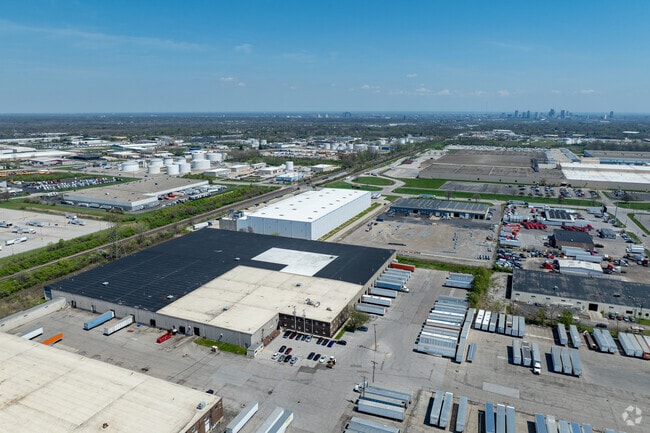
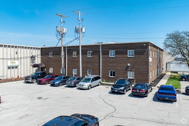
Property Detail
0 Janitrol Rd
Columbus, OH
JANITROLRD 1.671 ACRS ENTRY 1482-1425 10-16
140-006509
FRANKLIN
Industrialgeneral
Ohio
B and X Area of moderate flood hazard, usually the area between the limits of the 100-year and 500-year floods.
1.67 AC
2024
Downtown West
2025
Columbus
030600
NEARBY LISTINGS FOR SALE OR LEASE
DEMOGRAPHICS near 0 Janitrol Rd
1 mile
3 mile
5 mile
2025 Total Population
3,264
111,959
256,890
2030 Population
3,340
115,484
264,445
Pop Growth 2025-2030
+ 2.33%
+ 3.15%
+ 2.94%
Average Age
40
36
37
2025 Total Households
1,414
44,158
103,540
HH Growth 2025-2030
+ 2.40%
+ 3.14%
+ 2.95%
Median Household Inc
$55,898
$61,570
$71,788
Avg Household Size
2.30
2.50
2.40
2025 Avg HH Vehicles
2.00
2.00
2.00
Median Home Value
$176,430
$232,273
$277,107
Median Year Built
1958
1980
1979
Nearby Places
Map Layers
Map Styles
 Street
 Aerial
Layers
 Traffic
 Biking
Places
Listings with unknown addresses are not visible on the map
- Restaurants
- Banks
- Shops
- Fitness
- Groceries
PUBLIC TRANSPORTATION
AIRPORT
John Glenn Columbus International
Drive
Walk
Distance
John Glenn Columbus International
23 min
14.2 mi
Rickenbacker International
Drive
Walk
Distance
Rickenbacker International
27 min
18.2 mi
Freight Ports
Port of Toledo
Drive
Walk
Distance
Port of Toledo
186 min
136.6 mi
SALE & LEASE HISTORY
LISTING DATE
SALE/LEASE

Feb 01, 2024
For Lease
Nearby Properties
Address
Land Use
TOTAL SIZE
Lot Size
Zoning
Address
Land Use
TOTAL SIZE
Lot Size
Zoning
764,116 SF
256.31 AC
Address
Land Use
TOTAL SIZE
Lot Size
Zoning
1,215,421 SF
108.07 AC
Address
Land Use
TOTAL SIZE
Lot Size
Zoning
642,900 SF
21.84 AC
Address
Land Use
TOTAL SIZE
Lot Size
Zoning
269,165 SF
7 AC
Address
Land Use
TOTAL SIZE
Lot Size
Zoning
961,554 SF
75.09 AC
Address
Land Use
TOTAL SIZE
Lot Size
Zoning
257,723 SF
38.06 AC
Address
Land Use
TOTAL SIZE
Lot Size
Zoning
87,654 SF
45.30 AC
Address
Land Use
TOTAL SIZE
Lot Size
Zoning
329,215 SF
8.33 AC
Address
Land Use
TOTAL SIZE
Lot Size
Zoning
34,521 SF
29.23 AC
Address
Land Use
TOTAL SIZE
Lot Size
Zoning
538,680 SF
32.49 AC
Address
Land Use
TOTAL SIZE
Lot Size
Zoning
50,837 SF
10.12 AC
Address
Land Use
TOTAL SIZE
Lot Size
Zoning
70,995 SF
38.78 AC
Address
Land Use
TOTAL SIZE
Lot Size
Zoning
255,902 SF
8.15 AC
Address
Land Use
TOTAL SIZE
Lot Size
Zoning
156,839 SF
48.45 AC
Address
Land Use
TOTAL SIZE
Lot Size
Zoning
155,280 SF
0.23 AC
Address
Land Use
TOTAL SIZE
Lot Size
Zoning
1,011,597 SF
49.94 AC
Address
Land Use
TOTAL SIZE
Lot Size
Zoning
566,334 SF
58.62 AC
Address
Land Use
TOTAL SIZE
Lot Size
Zoning
25,368 SF
27.23 AC
Address
Land Use
TOTAL SIZE
Lot Size
Zoning
96,602 SF
0.21 AC
Address
Land Use
TOTAL SIZE
Lot Size
Zoning
108,828 SF
23.51 AC
Address
Land Use
TOTAL SIZE
Lot Size
Zoning
247,354 SF
30.38 AC
Address
Land Use
TOTAL SIZE
Lot Size
Zoning
143.78 AC
Address
Land Use
TOTAL SIZE
Lot Size
Zoning
293,744 SF
20.12 AC
Address
Land Use
TOTAL SIZE
Lot Size
Zoning
157,875 SF
0.19 AC
Address
Land Use
TOTAL SIZE
Lot Size
Zoning
62,400 SF
9.02 AC
Address
Land Use
TOTAL SIZE
Lot Size
Zoning
759,600 SF
23.75 AC
Address
Land Use
TOTAL SIZE
Lot Size
Zoning
138,003 SF
2.94 AC
Address
Land Use
TOTAL SIZE
Lot Size
Zoning
131,116 SF
15.30 AC
Address
Land Use
TOTAL SIZE
Lot Size
Zoning
202,330 SF
18.89 AC
Address
Land Use
TOTAL SIZE
Lot Size
Zoning
178,452 SF
34.84 AC
The World's #1 Commercial Real Estate Marketplace
Connect with us
© 2026 CoStar Group
The information above has been obtained from sources believed reliable. While we do not doubt its accuracy we have not verified it and make no guarantee, warranty or representation about it. It is your responsibility to independently confirm its accuracy and completeness. Any projections, opinions, assumptions, or estimates used are for example only and do not represent the current or future performance of the property. The value of this transaction to you depends on tax and other factors which should be evaluated by your tax, financial, and legal advisors. You and your advisors should conduct a careful, independent investigation of the property to determine to your satisfaction the suitability of the property for your needs.