Property Record
Jimmy Deloach Pkwy, Bloomingdale, GA 31302
This Property Is For Sale
NEARBY LISTINGS FOR SALE OR LEASE
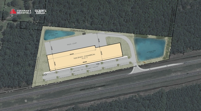
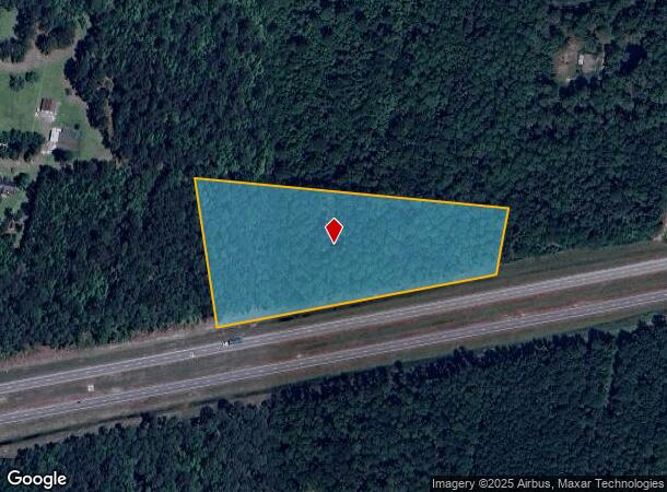
Property Detail
Jimmy Deloach Pkwy
Savannah, GA
West Side 1
8101901061
TRACT 4 PT OF COLLINS PROPERTY 7TH GMD, BLOOMINGDALE 52/604
Residentialacreage
Chatham
X
Georgia
13103C0370E
6.74 AC
2023
Bloomingdale/Pooler
2025
Savannah
010801
DEMOGRAPHICS near Jimmy Deloach Pkwy
1 Mile
3 Mile
5 Mile
2024 Total Population
184
19,069
52,977
2029 Population
203
20,560
57,303
Pop Growth 2024-2029
+ 10.33%
+ 7.82%
+ 8.17%
Average Age
41
38
37
2024 Total Households
68
7,615
20,383
HH Growth 2024-2029
+ 10.29%
+ 7.13%
+ 7.71%
Median Household Inc
$69,642
$84,931
$85,109
Avg Household Size
2.80
2.50
2.60
2024 Avg HH Vehicles
2.00
2.00
2.00
Median Home Value
$357,142
$245,028
$238,790
Median Year Built
2000
2006
2007
Nearby Places
- Restaurants
- Banks
- Shops
- Fitness
- Groceries
PUBLIC TRANSPORTATION
AIRPORT
Savannah/Hilton Head International
DRIVE
WALK
Distance
Savannah/Hilton Head International
24 min
11.9 mi
Freight Ports
Georgia Ports - Savannah
DRIVE
WALK
Distance
Georgia Ports - Savannah
25 min
14.6 mi
Nearby Properties
Address
Land Use
TOTAL SIZE
Lot Size
Zoning
Address
Land Use
TOTAL SIZE
Lot Size
Zoning
1,080,000 SF
71.17 AC
PUD
Address
Land Use
TOTAL SIZE
Lot Size
Zoning
1,460,340 SF
89.96 AC
RA-1
Address
Land Use
TOTAL SIZE
Lot Size
Zoning
1,193,920 SF
84.08 AC
PUD
Address
Land Use
TOTAL SIZE
Lot Size
Zoning
920,550 SF
50.12 AC
I-1
Address
Land Use
TOTAL SIZE
Lot Size
Zoning
728,500 SF
67.67 AC
Address
Land Use
TOTAL SIZE
Lot Size
Zoning
998,400 SF
123.21 AC
Address
Land Use
TOTAL SIZE
Lot Size
Zoning
4,800 SF
35.20 AC
I-1
Address
Land Use
TOTAL SIZE
Lot Size
Zoning
103,840 SF
49.10 AC
I-L
Address
Land Use
TOTAL SIZE
Lot Size
Zoning
25,656 SF
23.69 AC
PUDC
Address
Land Use
TOTAL SIZE
Lot Size
Zoning
234,700 SF
52.22 AC
PUD
Address
Land Use
TOTAL SIZE
Lot Size
Zoning
22,220 SF
27.20 AC
PUDC
Address
Land Use
TOTAL SIZE
Lot Size
Zoning
35,352 SF
21.22 AC
PUD
Address
Land Use
TOTAL SIZE
Lot Size
Zoning
33.46 AC
PUD
Address
Land Use
TOTAL SIZE
Lot Size
Zoning
33.42 AC
PUD
Address
Land Use
TOTAL SIZE
Lot Size
Zoning
34,404 SF
20 AC
C2
Address
Land Use
TOTAL SIZE
Lot Size
Zoning
24,555 SF
18.54 AC
PUDC
Address
Land Use
TOTAL SIZE
Lot Size
Zoning
15,804 SF
17 AC
R3
Address
Land Use
TOTAL SIZE
Lot Size
Zoning
403,000 SF
20.34 AC
PUD
Address
Land Use
TOTAL SIZE
Lot Size
Zoning
28,008 SF
14.69 AC
PUDC
Address
Land Use
TOTAL SIZE
Lot Size
Zoning
8,464 SF
32.62 AC
RA1
Address
Land Use
TOTAL SIZE
Lot Size
Zoning
361,200 SF
28.48 AC
PUD
Address
Land Use
TOTAL SIZE
Lot Size
Zoning
290,524 SF
21.52 AC
Address
Land Use
TOTAL SIZE
Lot Size
Zoning
345,600 SF
22.22 AC
PUD
Address
Land Use
TOTAL SIZE
Lot Size
Zoning
22,472 SF
15.09 AC
PUD-M8
Address
Land Use
TOTAL SIZE
Lot Size
Zoning
357,760 SF
21.19 AC
RA-1
Address
Land Use
TOTAL SIZE
Lot Size
Zoning
12,025 SF
13.23 AC
PUD
Address
Land Use
TOTAL SIZE
Lot Size
Zoning
9,240 SF
28.82 AC
PUD
Address
Land Use
TOTAL SIZE
Lot Size
Zoning
1,852 SF
22.60 AC
PUD
Address
Land Use
TOTAL SIZE
Lot Size
Zoning
141,851 SF
4.04 AC
PUDC
Address
Land Use
TOTAL SIZE
Lot Size
Zoning
304,920 SF
16.73 AC
PUD
The World's #1 Commercial Real Estate Marketplace
Connect with us
© 2025 CoStar Group
The information above has been obtained from sources believed reliable. While we do not doubt its accuracy we have not verified it and make no guarantee, warranty or representation about it. It is your responsibility to independently confirm its accuracy and completeness. Any projections, opinions, assumptions, or estimates used are for example only and do not represent the current or future performance of the property. The value of this transaction to you depends on tax and other factors which should be evaluated by your tax, financial, and legal advisors. You and your advisors should conduct a careful, independent investigation of the property to determine to your satisfaction the suitability of the property for your needs.