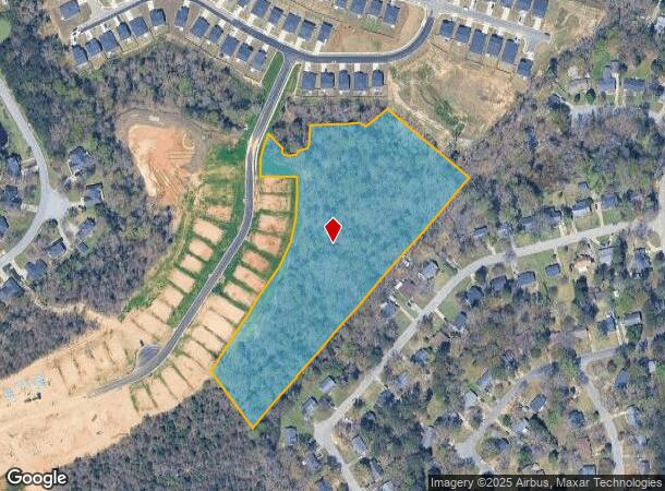
Property Record
Koon Rd, Irmo, SC 29063
NEARBY LISTINGS FOR SALE OR LEASE
Property Detail
Koon Rd
03400-02-56
#SU #PR RB2758-3258 RB2730-1662 RB2798-3875
Agriculturalland
Richland
X
South Carolina
45079C0089L
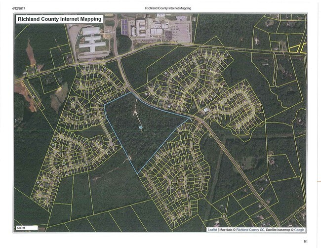
38.34 AC
2025
Dutch Fork/Irmo
2024
Columbia
010308
Columbia, SC
DEMOGRAPHICS near Koon Rd
1 mile
3 mile
5 mile
2024 Total Population
2,058
19,753
53,044
2029 Population
2,081
19,920
54,171
Pop Growth 2024-2029
+ 1.12%
+ 0.85%
+ 2.12%
Average Age
39
38
40
2024 Total Households
733
7,059
20,303
HH Growth 2024-2029
+ 1.23%
+ 0.86%
+ 2.26%
Median Household Inc
$123,185
$100,072
$90,853
Avg Household Size
2.80
2.80
2.60
2024 Avg HH Vehicles
3.00
2.00
2.00
Median Home Value
$263,451
$247,746
$242,424
Median Year Built
2001
2000
1995
Nearby Places
Map Layers
Map Styles
 Street
 Aerial
Transit
 Traffic
 Biking
Places
Listings with unknown addresses are not visible on the map
- Restaurants
- Banks
- Shops
- Fitness
- Groceries
PUBLIC TRANSPORTATION
AIRPORT
Columbia Metro
Drive
Walk
Distance
Columbia Metro
42 min
20.8 mi
Freight Ports
North Charleston Terminal
Drive
Walk
Distance
North Charleston Terminal
141 min
117.1 mi
SALE & LEASE HISTORY
LISTING DATE
SALE/LEASE

Apr 12, 2017
For Sale
Nearby Properties
Address
Land Use
TOTAL SIZE
Lot Size
Zoning
Address
Land Use
TOTAL SIZE
Lot Size
Zoning
3,957 SF
20.32 AC
GC
Address
Land Use
TOTAL SIZE
Lot Size
Zoning
191,009 SF
28.02 AC
CG
Address
Land Use
TOTAL SIZE
Lot Size
Zoning
21,580 SF
16.15 AC
GC
Address
Land Use
TOTAL SIZE
Lot Size
Zoning
56,750 SF
8.16 AC
M-1
Address
Land Use
TOTAL SIZE
Lot Size
Zoning
76,066 SF
7.29 AC
M-1
Address
Land Use
TOTAL SIZE
Lot Size
Zoning
56,958 SF
6.21 AC
CG
Address
Land Use
TOTAL SIZE
Lot Size
Zoning
9.83 AC
CG
Address
Land Use
TOTAL SIZE
Lot Size
Zoning
56,588 SF
6.46 AC
GC
Address
Land Use
TOTAL SIZE
Lot Size
Zoning
15,205 SF
2.05 AC
C-3
Address
Land Use
TOTAL SIZE
Lot Size
Zoning
31,032 SF
7.36 AC
GC
Address
Land Use
TOTAL SIZE
Lot Size
Zoning
8.57 AC
CG
Address
Land Use
TOTAL SIZE
Lot Size
Zoning
11,917 SF
5.72 AC
RU
Address
Land Use
TOTAL SIZE
Lot Size
Zoning
14,370 SF
6.84 AC
RU
Address
Land Use
TOTAL SIZE
Lot Size
Zoning
720 SF
2.97 AC
RU
Address
Land Use
TOTAL SIZE
Lot Size
Zoning
24,049 SF
5.13 AC
CG
Address
Land Use
TOTAL SIZE
Lot Size
Zoning
24,049 SF
4.30 AC
CG
Address
Land Use
TOTAL SIZE
Lot Size
Zoning
23,439 SF
7.68 AC
RU
Address
Land Use
TOTAL SIZE
Lot Size
Zoning
15,252 SF
5.70 AC
RS-LD
Address
Land Use
TOTAL SIZE
Lot Size
Zoning
17,805 SF
23.60 AC
RS
Address
Land Use
TOTAL SIZE
Lot Size
Zoning
23,600 SF
3.50 AC
M-1
Address
Land Use
TOTAL SIZE
Lot Size
Zoning
10,953 SF
1.20 AC
GC
Address
Land Use
TOTAL SIZE
Lot Size
Zoning
10 AC
PDD
Address
Land Use
TOTAL SIZE
Lot Size
Zoning
32,200 SF
2.33 AC
M-1
Address
Land Use
TOTAL SIZE
Lot Size
Zoning
3,565 SF
2.75 AC
CG
Address
Land Use
TOTAL SIZE
Lot Size
Zoning
14.62 AC
M-1
Address
Land Use
TOTAL SIZE
Lot Size
Zoning
15,750 SF
5.83 AC
PDD
Address
Land Use
TOTAL SIZE
Lot Size
Zoning
19,320 SF
4.08 AC
GC
Address
Land Use
TOTAL SIZE
Lot Size
Zoning
16,856 SF
2.78 AC
M-1
Address
Land Use
TOTAL SIZE
Lot Size
Zoning
3,830 SF
3 AC
M-1
Address
Land Use
TOTAL SIZE
Lot Size
Zoning
19,500 SF
2 AC
M-1
The World's #1 Commercial Real Estate Marketplace
Connect with us
© 2026 CoStar Group
The information above has been obtained from sources believed reliable. While we do not doubt its accuracy we have not verified it and make no guarantee, warranty or representation about it. It is your responsibility to independently confirm its accuracy and completeness. Any projections, opinions, assumptions, or estimates used are for example only and do not represent the current or future performance of the property. The value of this transaction to you depends on tax and other factors which should be evaluated by your tax, financial, and legal advisors. You and your advisors should conduct a careful, independent investigation of the property to determine to your satisfaction the suitability of the property for your needs.