Property Record
95 A Nectar St, Reno, NV 89506
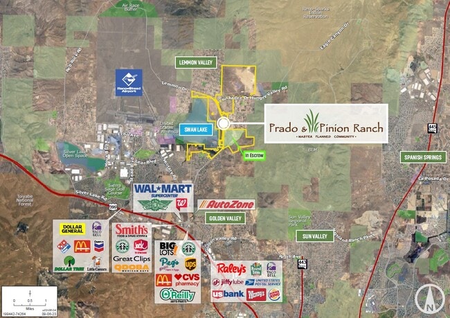

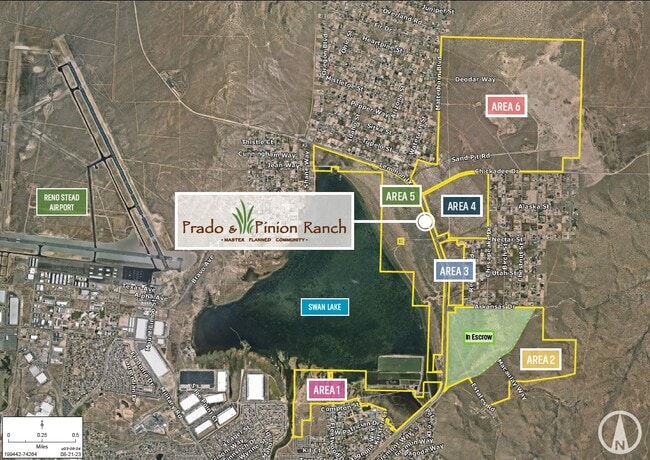

This Property Is For Sale
Property Detail
95 A Nectar St
Reno, NV
PRADO RANCH NORTH PHASE 1 PAR C
540-051-01
WASHOE
Vacantlandnec
Nevada
MDS4
par.c
2025
116.86 AC
2026
N Outlying Washoe County
002615
Reno/Sparks
NEARBY LISTINGS FOR SALE OR LEASE
DEMOGRAPHICS near 95 A Nectar St
1 mile
3 mile
5 mile
2025 Total Population
1,155
10,232
40,410
2030 Population
1,173
10,728
41,981
Pop Growth 2025-2030
+ 1.56%
+ 4.85%
+ 3.89%
Average Age
43
39
38
2025 Total Households
407
3,374
13,769
HH Growth 2025-2030
+ 1.72%
+ 4.71%
+ 3.91%
Median Household Inc
$90,376
$84,867
$87,508
Avg Household Size
2.80
2.90
2.90
2025 Avg HH Vehicles
3.00
2.00
2.00
Median Home Value
$420,689
$421,578
$424,661
Median Year Built
1977
1999
1999
Nearby Places
Map Layers
Map Styles
 Street
 Aerial
Transit
 Traffic
 Biking
Places
Listings with unknown addresses are not visible on the map
- Restaurants
- Banks
- Shops
- Fitness
- Groceries
PUBLIC TRANSPORTATION
AIRPORT
Reno/Tahoe International
Drive
Walk
Distance
Reno/Tahoe International
38 min
16.8 mi
Freight Ports
Port of Stockton
Drive
Walk
Distance
Port of Stockton
223 min
191.2 mi
Nearby Properties
Address
Land Use
TOTAL SIZE
Lot Size
Zoning
Address
Land Use
TOTAL SIZE
Lot Size
Zoning
902,786 SF
57.98 AC
IC
Address
Land Use
TOTAL SIZE
Lot Size
Zoning
622,807 SF
45.97 AC
IC
Address
Land Use
TOTAL SIZE
Lot Size
Zoning
722,512 SF
43.90 AC
IC
Address
Land Use
TOTAL SIZE
Lot Size
Zoning
530,693 SF
48.34 AC
IC
Address
Land Use
TOTAL SIZE
Lot Size
Zoning
10,255 SF
45.62 AC
PF
Address
Land Use
TOTAL SIZE
Lot Size
Zoning
676,431 SF
32.10 AC
I
Address
Land Use
TOTAL SIZE
Lot Size
Zoning
259,740 SF
12.49 AC
IC
Address
Land Use
TOTAL SIZE
Lot Size
Zoning
240,500 SF
13.26 AC
I
Address
Land Use
TOTAL SIZE
Lot Size
Zoning
265,375 SF
16.11 AC
I
Address
Land Use
TOTAL SIZE
Lot Size
Zoning
121,304 SF
44.96 AC
PF
Address
Land Use
TOTAL SIZE
Lot Size
Zoning
167,400 SF
11.24 AC
IC
Address
Land Use
TOTAL SIZE
Lot Size
Zoning
230,550 SF
13.23 AC
I
Address
Land Use
TOTAL SIZE
Lot Size
Zoning
181,440 SF
12.93 AC
I
Address
Land Use
TOTAL SIZE
Lot Size
Zoning
162,402 SF
14.16 AC
I
Address
Land Use
TOTAL SIZE
Lot Size
Zoning
263,500 SF
12.42 AC
I
Address
Land Use
TOTAL SIZE
Lot Size
Zoning
8,024 SF
11.13 AC
IC
Address
Land Use
TOTAL SIZE
Lot Size
Zoning
63,024 SF
3.59 AC
MF30
Address
Land Use
TOTAL SIZE
Lot Size
Zoning
38,080 SF
2.64 AC
GC
Address
Land Use
TOTAL SIZE
Lot Size
Zoning
44,181 SF
8.76 AC
PSP
Address
Land Use
TOTAL SIZE
Lot Size
Zoning
49,286 SF
29.97 AC
MA
Address
Land Use
TOTAL SIZE
Lot Size
Zoning
61.06 AC
MA
Address
Land Use
TOTAL SIZE
Lot Size
Zoning
37,952 SF
4.94 AC
IC
Address
Land Use
TOTAL SIZE
Lot Size
Zoning
37.21 AC
PSP
Address
Land Use
TOTAL SIZE
Lot Size
Zoning
19,316 SF
3.92 AC
GC
Address
Land Use
TOTAL SIZE
Lot Size
Zoning
41,033 SF
1.93 AC
I
Address
Land Use
TOTAL SIZE
Lot Size
Zoning
35.07 AC
SF8
Address
Land Use
TOTAL SIZE
Lot Size
Zoning
720 AC
OS 40% / G
Address
Land Use
TOTAL SIZE
Lot Size
Zoning
28,600 SF
5.70 AC
MDS 14% /
Address
Land Use
TOTAL SIZE
Lot Size
Zoning
1 AC
GR
Address
Land Use
TOTAL SIZE
Lot Size
Zoning
19.93 AC
MDS 28% /
The World's #1 Commercial Real Estate Marketplace
Connect with us
© 2026 CoStar Group
The information above has been obtained from sources believed reliable. While we do not doubt its accuracy we have not verified it and make no guarantee, warranty or representation about it. It is your responsibility to independently confirm its accuracy and completeness. Any projections, opinions, assumptions, or estimates used are for example only and do not represent the current or future performance of the property. The value of this transaction to you depends on tax and other factors which should be evaluated by your tax, financial, and legal advisors. You and your advisors should conduct a careful, independent investigation of the property to determine to your satisfaction the suitability of the property for your needs.