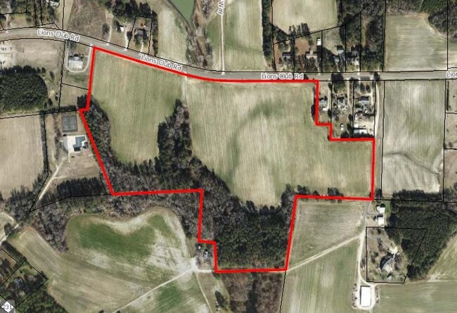
Property Record
0 Lions Club Rd, Wendell, NC 27591
NEARBY LISTINGS FOR SALE OR LEASE
Property Detail
0 Lions Club Rd
Raleigh, NC
Belle Grove
1793.09-26-3863-000
LOFD BELLE GROVE FUT DEV
Vacantlandnec
Wake
X
North Carolina
3720179300L
22.33 AC
2025
Northeast Wake County
2025
Raleigh/Durham
054402
DEMOGRAPHICS near 0 Lions Club Rd
1 Mile
3 Mile
5 Mile
2024 Total Population
2,249
11,872
35,789
2029 Population
2,452
13,240
40,775
Pop Growth 2024-2029
+ 9.03%
+ 11.52%
+ 13.93%
Average Age
38
39
39
2024 Total Households
823
4,346
13,145
HH Growth 2024-2029
+ 8.99%
+ 11.60%
+ 13.92%
Median Household Inc
$81,346
$73,631
$78,817
Avg Household Size
2.70
2.70
2.70
2024 Avg HH Vehicles
2.00
2.00
2.00
Median Home Value
$246,223
$251,854
$271,479
Median Year Built
1992
1990
1997
Nearby Places
- Restaurants
- Banks
- Shops
- Fitness
- Groceries
PUBLIC TRANSPORTATION
AIRPORT
Raleigh-Durham International
DRIVE
WALK
Distance
Raleigh-Durham International
44 min
30.7 mi
Freight Ports
Port of Wilmington
DRIVE
WALK
Distance
Port of Wilmington
167 min
138.0 mi
SALE & LEASE HISTORY
LISTING DATE
SALE/LEASE

Dec 09, 2019
For Sale
Nearby Properties
Address
Land Use
TOTAL SIZE
Lot Size
Zoning
Address
Land Use
TOTAL SIZE
Lot Size
Zoning
377,673 SF
27.54 AC
PUD-1
Address
Land Use
TOTAL SIZE
Lot Size
Zoning
176,286 SF
103.50 AC
CMX
Address
Land Use
TOTAL SIZE
Lot Size
Zoning
301,933 SF
12.92 AC
PUD-1
Address
Land Use
TOTAL SIZE
Lot Size
Zoning
328,918 SF
17.24 AC
CMX-C
Address
Land Use
TOTAL SIZE
Lot Size
Zoning
356,188 SF
31.21 AC
MI-CD
Address
Land Use
TOTAL SIZE
Lot Size
Zoning
152,472 SF
24.42 AC
R-40
Address
Land Use
TOTAL SIZE
Lot Size
Zoning
81,915 SF
18.72 AC
CH
Address
Land Use
TOTAL SIZE
Lot Size
Zoning
61,750 SF
12.01 AC
PUD-1
Address
Land Use
TOTAL SIZE
Lot Size
Zoning
105,512 SF
17.63 AC
R3
Address
Land Use
TOTAL SIZE
Lot Size
Zoning
271,950 SF
128.61 AC
I-2
Address
Land Use
TOTAL SIZE
Lot Size
Zoning
66,695 SF
19.89 AC
NC
Address
Land Use
TOTAL SIZE
Lot Size
Zoning
86,168 SF
19.65 AC
RA
Address
Land Use
TOTAL SIZE
Lot Size
Zoning
41,572 SF
43.57 AC
CMX-C
Address
Land Use
TOTAL SIZE
Lot Size
Zoning
24,519 SF
10.79 AC
PUD-1
Address
Land Use
TOTAL SIZE
Lot Size
Zoning
83,654 SF
5.80 AC
NC
Address
Land Use
TOTAL SIZE
Lot Size
Zoning
138,653 SF
45.85 AC
MI
Address
Land Use
TOTAL SIZE
Lot Size
Zoning
17.90 AC
PUD-1
Address
Land Use
TOTAL SIZE
Lot Size
Zoning
54,085 SF
60.87 AC
R-30
Address
Land Use
TOTAL SIZE
Lot Size
Zoning
38,093 SF
1.73 AC
DMX
Address
Land Use
TOTAL SIZE
Lot Size
Zoning
48,976 SF
5.86 AC
PUD-1
Address
Land Use
TOTAL SIZE
Lot Size
Zoning
672 SF
197.30 AC
PUD
Address
Land Use
TOTAL SIZE
Lot Size
Zoning
65,300 SF
11.64 AC
CMX
Address
Land Use
TOTAL SIZE
Lot Size
Zoning
16,776 SF
6.63 AC
R3
Address
Land Use
TOTAL SIZE
Lot Size
Zoning
40,897 SF
8.67 AC
CMX-C
Address
Land Use
TOTAL SIZE
Lot Size
Zoning
249 AC
PUD
Address
Land Use
TOTAL SIZE
Lot Size
Zoning
48,400 SF
5.87 AC
CMX
Address
Land Use
TOTAL SIZE
Lot Size
Zoning
30,240 SF
8.01 AC
RR
Address
Land Use
TOTAL SIZE
Lot Size
Zoning
7,491 SF
20.33 AC
PUD-2
Address
Land Use
TOTAL SIZE
Lot Size
Zoning
28,189 SF
3 AC
PUD-1
Address
Land Use
TOTAL SIZE
Lot Size
Zoning
14,626 SF
8.11 AC
CMX
The World's #1 Commercial Real Estate Marketplace
Connect with us
© 2025 CoStar Group
The information above has been obtained from sources believed reliable. While we do not doubt its accuracy we have not verified it and make no guarantee, warranty or representation about it. It is your responsibility to independently confirm its accuracy and completeness. Any projections, opinions, assumptions, or estimates used are for example only and do not represent the current or future performance of the property. The value of this transaction to you depends on tax and other factors which should be evaluated by your tax, financial, and legal advisors. You and your advisors should conduct a careful, independent investigation of the property to determine to your satisfaction the suitability of the property for your needs.