Property Record
0 Lockbourne Rd, Hamilton, OH 43137


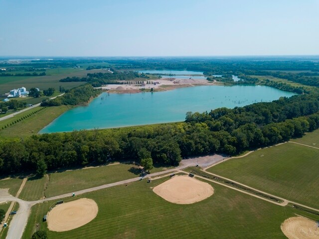

Property Detail
0 Lockbourne Rd
150-000411
LOCKBOURNE RD R22 T4 S3-5, 26-35 LOTS 34-35 (372.917 ACRES)
Municipalproperty
FRANKLIN
AE The base floodplain where base flood elevations are provided. AE Zones are now used on new format FIRMs instead of A1-A30 Zones.
Ohio
0
372.92 AC
2025
Southeast
009590
Columbus
8,132 SF
Columbus, OH
NEARBY LISTINGS FOR SALE OR LEASE
DEMOGRAPHICS near 0 Lockbourne Rd
1 mile
3 mile
5 mile
2025 Total Population
1,191
18,322
63,247
2030 Population
1,229
18,992
65,441
Pop Growth 2025-2030
+ 3.19%
+ 3.66%
+ 3.47%
Average Age
45
39
40
2025 Total Households
492
6,565
23,841
HH Growth 2025-2030
+ 3.46%
+ 3.76%
+ 3.53%
Median Household Inc
$68,955
$70,108
$75,676
Avg Household Size
2.40
2.80
2.60
2025 Avg HH Vehicles
2.00
2.00
2.00
Median Home Value
$220,530
$224,633
$252,401
Median Year Built
1971
1977
1987
Nearby Places
Map Layers
Map Styles
 Street
 Aerial
Layers
 Traffic
 Biking
Places
Listings with unknown addresses are not visible on the map
- Restaurants
- Banks
- Shops
- Fitness
- Groceries
PUBLIC TRANSPORTATION
AIRPORT
Rickenbacker International
Drive
Walk
Distance
Rickenbacker International
9 min
3.9 mi
John Glenn Columbus International
Drive
Walk
Distance
John Glenn Columbus International
29 min
17.7 mi
SALE & LEASE HISTORY
LISTING DATE
SALE/LEASE

Aug 04, 2017
For Sale
Nearby Properties
Address
Land Use
TOTAL SIZE
Lot Size
Zoning
Address
Land Use
TOTAL SIZE
Lot Size
Zoning
33,110 SF
168.33 AC
Address
Land Use
TOTAL SIZE
Lot Size
Zoning
1,172,656 SF
480.43 AC
Address
Land Use
TOTAL SIZE
Lot Size
Zoning
4,200 SF
852.55 AC
Address
Land Use
TOTAL SIZE
Lot Size
Zoning
284,628 SF
167.80 AC
Address
Land Use
TOTAL SIZE
Lot Size
Zoning
1,075,600 SF
49.33 AC
Address
Land Use
TOTAL SIZE
Lot Size
Zoning
1,466,512 SF
49.72 AC
Address
Land Use
TOTAL SIZE
Lot Size
Zoning
43,254 SF
300.98 AC
Address
Land Use
TOTAL SIZE
Lot Size
Zoning
20,888 SF
181 AC
Address
Land Use
TOTAL SIZE
Lot Size
Zoning
1,054,500 SF
59.77 AC
Address
Land Use
TOTAL SIZE
Lot Size
Zoning
1,219,000 SF
59.32 AC
Address
Land Use
TOTAL SIZE
Lot Size
Zoning
1,021,020 SF
68.44 AC
Address
Land Use
TOTAL SIZE
Lot Size
Zoning
1,600,052 SF
70.19 AC
Address
Land Use
TOTAL SIZE
Lot Size
Zoning
150.29 AC
Address
Land Use
TOTAL SIZE
Lot Size
Zoning
816,200 SF
51.08 AC
Address
Land Use
TOTAL SIZE
Lot Size
Zoning
959,688 SF
55.34 AC
Address
Land Use
TOTAL SIZE
Lot Size
Zoning
778,272 SF
42.31 AC
Address
Land Use
TOTAL SIZE
Lot Size
Zoning
903,780 SF
45.43 AC
Address
Land Use
TOTAL SIZE
Lot Size
Zoning
720,200 SF
35.71 AC
Address
Land Use
TOTAL SIZE
Lot Size
Zoning
785,854 SF
30.85 AC
Address
Land Use
TOTAL SIZE
Lot Size
Zoning
676,000 SF
35.76 AC
Address
Land Use
TOTAL SIZE
Lot Size
Zoning
Address
Land Use
TOTAL SIZE
Lot Size
Zoning
592,120 SF
38.67 AC
Address
Land Use
TOTAL SIZE
Lot Size
Zoning
547,200 SF
43.58 AC
Address
Land Use
TOTAL SIZE
Lot Size
Zoning
743,315 SF
42.17 AC
Address
Land Use
TOTAL SIZE
Lot Size
Zoning
130,865 SF
9.97 AC
Address
Land Use
TOTAL SIZE
Lot Size
Zoning
767,697 SF
39.49 AC
Address
Land Use
TOTAL SIZE
Lot Size
Zoning
655,288 SF
40.76 AC
Address
Land Use
TOTAL SIZE
Lot Size
Zoning
590,225 SF
42.21 AC
Address
Land Use
TOTAL SIZE
Lot Size
Zoning
245,756 SF
102.40 AC
Address
Land Use
TOTAL SIZE
Lot Size
Zoning
737,054 SF
37.15 AC
The World's #1 Commercial Real Estate Marketplace
Connect with us
© 2026 CoStar Group
The information above has been obtained from sources believed reliable. While we do not doubt its accuracy we have not verified it and make no guarantee, warranty or representation about it. It is your responsibility to independently confirm its accuracy and completeness. Any projections, opinions, assumptions, or estimates used are for example only and do not represent the current or future performance of the property. The value of this transaction to you depends on tax and other factors which should be evaluated by your tax, financial, and legal advisors. You and your advisors should conduct a careful, independent investigation of the property to determine to your satisfaction the suitability of the property for your needs.