Property Record
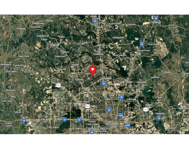
0 Louetta Rd, Spring, TX 77379


This Property Is For Sale
Property Detail
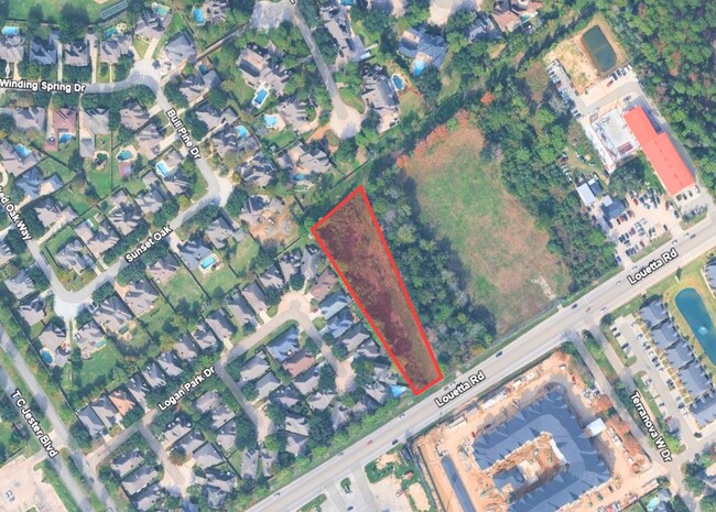
0 Louetta Rd
Houston-Pasadena-The Woodlands, TX
TR 1C-2 ABST 1050 HT & BRR CO SEC 2
0461520000044
HARRIS
Commercialacreage
Texas
B and X Area of moderate flood hazard, usually the area between the limits of the 100-year and 500-year floods.
1.14 AC
2024
FM 1960/Champions
2025
Houston
553804
NEARBY LISTINGS FOR SALE OR LEASE
DEMOGRAPHICS near 0 Louetta Rd
1 mile
3 mile
5 mile
2024 Total Population
11,030
106,909
299,905
2029 Population
11,769
113,739
319,928
Pop Growth 2024-2029
+ 6.70%
+ 6.39%
+ 6.68%
Average Age
41
39
38
2024 Total Households
3,647
37,143
105,740
HH Growth 2024-2029
+ 6.94%
+ 6.58%
+ 6.88%
Median Household Inc
$115,891
$97,924
$85,089
Avg Household Size
2.90
2.80
2.80
2024 Avg HH Vehicles
2.00
2.00
2.00
Median Home Value
$358,300
$328,981
$310,423
Median Year Built
1988
1990
1996
Nearby Places
Map Layers
Map Styles
 Street
 Aerial
Transit
 Traffic
 Biking
Places
Listings with unknown addresses are not visible on the map
- Restaurants
- Banks
- Shops
- Fitness
- Groceries
PUBLIC TRANSPORTATION
AIRPORT
George Bush Intcntl/Houston
Drive
Walk
Distance
George Bush Intcntl/Houston
27 min
17.3 mi
Freight Ports
Port of Houston
Drive
Walk
Distance
Port of Houston
48 min
31.0 mi
Nearby Properties
Address
Land Use
TOTAL SIZE
Lot Size
Zoning
Address
Land Use
TOTAL SIZE
Lot Size
Zoning
320,507 SF
25.29 AC
Address
Land Use
TOTAL SIZE
Lot Size
Zoning
341,895 SF
17.53 AC
Address
Land Use
TOTAL SIZE
Lot Size
Zoning
394,700 SF
17.34 AC
Address
Land Use
TOTAL SIZE
Lot Size
Zoning
180,249 SF
13.35 AC
Address
Land Use
TOTAL SIZE
Lot Size
Zoning
343,806 SF
17.76 AC
Address
Land Use
TOTAL SIZE
Lot Size
Zoning
434,400 SF
23.55 AC
Address
Land Use
TOTAL SIZE
Lot Size
Zoning
304,096 SF
14.80 AC
Address
Land Use
TOTAL SIZE
Lot Size
Zoning
266,594 SF
10.71 AC
Address
Land Use
TOTAL SIZE
Lot Size
Zoning
286,090 SF
13.25 AC
Address
Land Use
TOTAL SIZE
Lot Size
Zoning
413,131 SF
12.52 AC
Address
Land Use
TOTAL SIZE
Lot Size
Zoning
267,082 SF
11.13 AC
Address
Land Use
TOTAL SIZE
Lot Size
Zoning
348,658 SF
16.72 AC
Address
Land Use
TOTAL SIZE
Lot Size
Zoning
148,450 SF
18.26 AC
Address
Land Use
TOTAL SIZE
Lot Size
Zoning
304,518 SF
15 AC
Address
Land Use
TOTAL SIZE
Lot Size
Zoning
297,961 SF
18.04 AC
Address
Land Use
TOTAL SIZE
Lot Size
Zoning
173,371 SF
5.17 AC
Address
Land Use
TOTAL SIZE
Lot Size
Zoning
255,901 SF
11.01 AC
Address
Land Use
TOTAL SIZE
Lot Size
Zoning
222,479 SF
4.82 AC
Address
Land Use
TOTAL SIZE
Lot Size
Zoning
114,917 SF
18.61 AC
Address
Land Use
TOTAL SIZE
Lot Size
Zoning
247,670 SF
13.38 AC
Address
Land Use
TOTAL SIZE
Lot Size
Zoning
148,506 SF
Address
Land Use
TOTAL SIZE
Lot Size
Zoning
218,967 SF
14.11 AC
Address
Land Use
TOTAL SIZE
Lot Size
Zoning
145,051 SF
6.10 AC
Address
Land Use
TOTAL SIZE
Lot Size
Zoning
214,862 SF
14.92 AC
Address
Land Use
TOTAL SIZE
Lot Size
Zoning
268,232 SF
12.33 AC
Address
Land Use
TOTAL SIZE
Lot Size
Zoning
224,669 SF
15.40 AC
Address
Land Use
TOTAL SIZE
Lot Size
Zoning
118,475 SF
3.89 AC
Address
Land Use
TOTAL SIZE
Lot Size
Zoning
202,323 SF
9.37 AC
Address
Land Use
TOTAL SIZE
Lot Size
Zoning
350,072 SF
18.36 AC
Address
Land Use
TOTAL SIZE
Lot Size
Zoning
148,611 SF
5.84 AC
The World's #1 Commercial Real Estate Marketplace
Connect with us
© 2026 CoStar Group
The information above has been obtained from sources believed reliable. While we do not doubt its accuracy we have not verified it and make no guarantee, warranty or representation about it. It is your responsibility to independently confirm its accuracy and completeness. Any projections, opinions, assumptions, or estimates used are for example only and do not represent the current or future performance of the property. The value of this transaction to you depends on tax and other factors which should be evaluated by your tax, financial, and legal advisors. You and your advisors should conduct a careful, independent investigation of the property to determine to your satisfaction the suitability of the property for your needs.