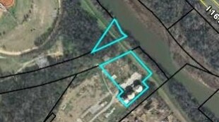
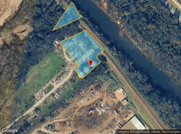
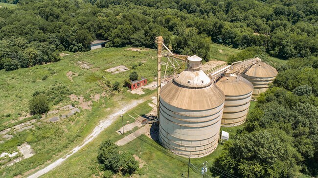
Property Record
Lowr Poplar St St, Macon, GA 31201
NEARBY LISTINGS FOR SALE OR LEASE
Property Detail
Lowr Poplar St St
S081-0007
Macon Reserve West Of The Ocmulgee River
Warehouse
Bibb
AE
Georgia
13169C0325E
56
2025
3.12 AC
2025
Suburban Macon
013701
Atlanta
3,000 SF
Macon-Bibb County, GA
DEMOGRAPHICS near Lowr Poplar St St
1 Mile
3 Mile
5 Mile
2024 Total Population
71
28,205
69,672
2029 Population
74
28,358
69,888
Pop Growth 2024-2029
+ 4.23%
+ 0.54%
+ 0.31%
Average Age
36
37
38
2024 Total Households
25
11,639
28,548
HH Growth 2024-2029
+ 4.00%
+ 0.88%
+ 0.43%
Median Household Inc
$29,999
$26,746
$33,922
Avg Household Size
2.40
2.10
2.30
2024 Avg HH Vehicles
1.00
1.00
1.00
Median Home Value
$174,999
$84,291
$95,575
Median Year Built
1962
1960
1962
Nearby Places
Map Layers
Map Styles
 Street
 Aerial
- Restaurants
- Banks
- Shops
- Fitness
- Groceries
SALE & LEASE HISTORY
LISTING DATE
SALE/LEASE

Jul 08, 2020
For Sale
Nearby Properties
Address
Land Use
TOTAL SIZE
Lot Size
Zoning
Address
Land Use
TOTAL SIZE
Lot Size
Zoning
55,368 SF
9.53 AC
CBD-2
Address
Land Use
TOTAL SIZE
Lot Size
Zoning
213,690 SF
2.25 AC
CBD-1
Address
Land Use
TOTAL SIZE
Lot Size
Zoning
154,196 SF
44.86 AC
R-1A
Address
Land Use
TOTAL SIZE
Lot Size
Zoning
63,394 SF
5.30 AC
M-1/R-3
Address
Land Use
TOTAL SIZE
Lot Size
Zoning
100,599 SF
0.43 AC
CBD-1
Address
Land Use
TOTAL SIZE
Lot Size
Zoning
158,480 SF
0.90 AC
CBD-2
Address
Land Use
TOTAL SIZE
Lot Size
Zoning
269,568 SF
29.43 AC
M-2
Address
Land Use
TOTAL SIZE
Lot Size
Zoning
241,380 SF
12.38 AC
C-2
Address
Land Use
TOTAL SIZE
Lot Size
Zoning
127,536 SF
3.56 AC
PDE
Address
Land Use
TOTAL SIZE
Lot Size
Zoning
155,678 SF
3.85 AC
CBD-2
Address
Land Use
TOTAL SIZE
Lot Size
Zoning
171,386 SF
36.41 AC
CBD-2
Address
Land Use
TOTAL SIZE
Lot Size
Zoning
92,712 SF
2.93 AC
CBD-2
Address
Land Use
TOTAL SIZE
Lot Size
Zoning
145,967 SF
2.53 AC
C-4
Address
Land Use
TOTAL SIZE
Lot Size
Zoning
98,928 SF
12.32 AC
R-3
Address
Land Use
TOTAL SIZE
Lot Size
Zoning
114,156 SF
0.86 AC
CBD-1
Address
Land Use
TOTAL SIZE
Lot Size
Zoning
246,724 SF
0.75 AC
CBD-1
Address
Land Use
TOTAL SIZE
Lot Size
Zoning
46,288 SF
1.80 AC
PDE
Address
Land Use
TOTAL SIZE
Lot Size
Zoning
33,248 SF
10.18 AC
R-3
Address
Land Use
TOTAL SIZE
Lot Size
Zoning
69,260 SF
0.41 AC
CBD-1
Address
Land Use
TOTAL SIZE
Lot Size
Zoning
60,432 SF
0.98 AC
CBD-1
Address
Land Use
TOTAL SIZE
Lot Size
Zoning
94,540 SF
6.15 AC
R-2
Address
Land Use
TOTAL SIZE
Lot Size
Zoning
183,682 SF
78.30 AC
M-2
Address
Land Use
TOTAL SIZE
Lot Size
Zoning
119,564 SF
3.89 AC
R-3
Address
Land Use
TOTAL SIZE
Lot Size
Zoning
58,730 SF
3.42 AC
R-3
Address
Land Use
TOTAL SIZE
Lot Size
Zoning
140 SF
29.43 AC
R-1
Address
Land Use
TOTAL SIZE
Lot Size
Zoning
72,073 SF
0.96 AC
CBD-1
Address
Land Use
TOTAL SIZE
Lot Size
Zoning
21,112 SF
1.11 AC
HR-3
Address
Land Use
TOTAL SIZE
Lot Size
Zoning
72,048 SF
2.84 AC
R-2
Address
Land Use
TOTAL SIZE
Lot Size
Zoning
8,480 SF
7.92 AC
HPD-BH
Address
Land Use
TOTAL SIZE
Lot Size
Zoning
350,100 SF
51.92 AC
M-2
The World's #1 Commercial Real Estate Marketplace
Connect with us
© 2025 CoStar Group
The information above has been obtained from sources believed reliable. While we do not doubt its accuracy we have not verified it and make no guarantee, warranty or representation about it. It is your responsibility to independently confirm its accuracy and completeness. Any projections, opinions, assumptions, or estimates used are for example only and do not represent the current or future performance of the property. The value of this transaction to you depends on tax and other factors which should be evaluated by your tax, financial, and legal advisors. You and your advisors should conduct a careful, independent investigation of the property to determine to your satisfaction the suitability of the property for your needs.