Property Record
M-52 Highway, Manchester, MI 48158
NEARBY LISTINGS FOR SALE OR LEASE
-
-
View all Manchester listings for sale on LoopNet.com
Property Detail
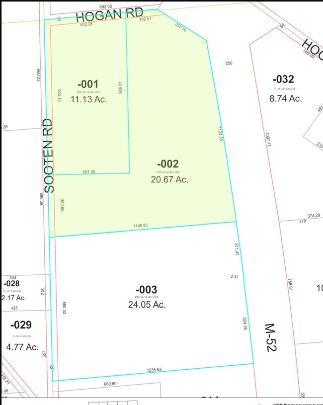
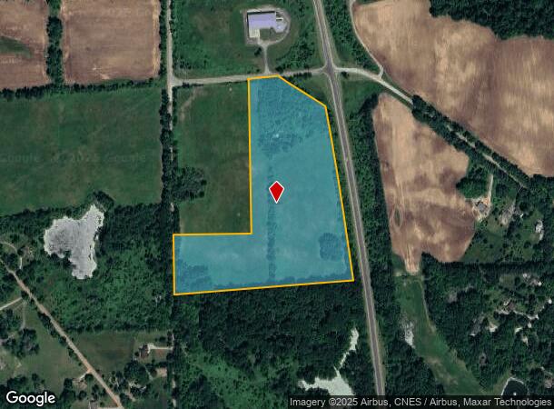
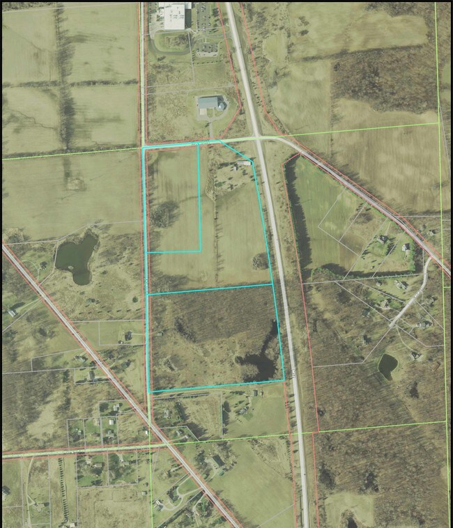
M-52 Highway
16-12-401-002
REWRITE PER PLAN 06/29/07 ANNEXED INTO VILLAGE 11/29/00 #00-119 MAV 12-13B PCL RC COM AT CENTER SEC 12
Commercialacreage
Washtenaw
X
Michigan
26161C0344E
20.67 AC
2025
Washtenaw W of 23
2025
Detroit
431000
Ann Arbor, MI
DEMOGRAPHICS near M-52 Highway
1 mile
3 mile
5 mile
2024 Total Population
572
3,749
6,492
2029 Population
562
3,678
6,372
Pop Growth 2024-2029
(1.75%)
(1.89%)
(1.85%)
Average Age
45
45
45
2024 Total Households
251
1,611
2,684
HH Growth 2024-2029
(1.99%)
(2.05%)
(1.97%)
Median Household Inc
$77,187
$81,818
$85,816
Avg Household Size
2.30
2.30
2.40
2024 Avg HH Vehicles
2.00
2.00
2.00
Median Home Value
$231,012
$248,882
$266,328
Median Year Built
1975
1975
1975
Nearby Places
Map Layers
Map Styles
 Street
 Aerial
Transit
 Traffic
 Biking
Places
Listings with unknown addresses are not visible on the map
- Restaurants
- Banks
- Shops
- Fitness
- Groceries
SALE & LEASE HISTORY
LISTING DATE
SALE/LEASE

Sep 24, 2016
For Sale
Nearby Properties
Address
Land Use
TOTAL SIZE
Lot Size
Zoning
Address
Land Use
TOTAL SIZE
Lot Size
Zoning
89,091 SF
8.36 AC
I-2 GEN
Address
Land Use
TOTAL SIZE
Lot Size
Zoning
231,551 SF
20.94 AC
I-2 GEN
Address
Land Use
TOTAL SIZE
Lot Size
Zoning
5,805 SF
56.76 AC
AR AGR
Address
Land Use
TOTAL SIZE
Lot Size
Zoning
78,345 SF
7.32 AC
CM COMM
Address
Land Use
TOTAL SIZE
Lot Size
Zoning
2,881 SF
61.48 AC
AG AGR
Address
Land Use
TOTAL SIZE
Lot Size
Zoning
5,146 SF
18.62 AC
AG
Address
Land Use
TOTAL SIZE
Lot Size
Zoning
1,152 SF
205.83 AC
AG
Address
Land Use
TOTAL SIZE
Lot Size
Zoning
4,641 SF
78.54 AC
AG
Address
Land Use
TOTAL SIZE
Lot Size
Zoning
3,176 SF
28.45 AC
AR AGR
Address
Land Use
TOTAL SIZE
Lot Size
Zoning
6,966 SF
53.16 AC
Address
Land Use
TOTAL SIZE
Lot Size
Zoning
180 SF
18.96 AC
AG AGR
Address
Land Use
TOTAL SIZE
Lot Size
Zoning
10,480 SF
60.25 AC
AG
Address
Land Use
TOTAL SIZE
Lot Size
Zoning
18,824 SF
5.35 AC
BI
Address
Land Use
TOTAL SIZE
Lot Size
Zoning
3,165 SF
39.49 AC
A-R
Address
Land Use
TOTAL SIZE
Lot Size
Zoning
22,701 SF
AG AGR
Address
Land Use
TOTAL SIZE
Lot Size
Zoning
19,570 SF
9.23 AC
I-2 GEN
Address
Land Use
TOTAL SIZE
Lot Size
Zoning
37 AC
R-1B SI
Address
Land Use
TOTAL SIZE
Lot Size
Zoning
28,172 SF
4.31 AC
R-2B MU
Address
Land Use
TOTAL SIZE
Lot Size
Zoning
1,825 SF
AG
Address
Land Use
TOTAL SIZE
Lot Size
Zoning
3,119 SF
48 AC
AR AGR
Address
Land Use
TOTAL SIZE
Lot Size
Zoning
43,197 SF
4.20 AC
I-3 URB
Address
Land Use
TOTAL SIZE
Lot Size
Zoning
2,474 SF
40 AC
AR AGR
Address
Land Use
TOTAL SIZE
Lot Size
Zoning
2,864 SF
65.12 AC
AG
Address
Land Use
TOTAL SIZE
Lot Size
Zoning
1,866 SF
21.07 AC
AG
Address
Land Use
TOTAL SIZE
Lot Size
Zoning
3,244 SF
12.30 AC
AR AGR
Address
Land Use
TOTAL SIZE
Lot Size
Zoning
3,544 SF
16.75 AC
A-R
Address
Land Use
TOTAL SIZE
Lot Size
Zoning
2,143 SF
80 AC
AR AGR
Address
Land Use
TOTAL SIZE
Lot Size
Zoning
8,946 SF
2.92 AC
C-2 GEN
Address
Land Use
TOTAL SIZE
Lot Size
Zoning
2,409 SF
110.78 AC
AG
The World's #1 Commercial Real Estate Marketplace
Connect with us
© 2026 CoStar Group
The information above has been obtained from sources believed reliable. While we do not doubt its accuracy we have not verified it and make no guarantee, warranty or representation about it. It is your responsibility to independently confirm its accuracy and completeness. Any projections, opinions, assumptions, or estimates used are for example only and do not represent the current or future performance of the property. The value of this transaction to you depends on tax and other factors which should be evaluated by your tax, financial, and legal advisors. You and your advisors should conduct a careful, independent investigation of the property to determine to your satisfaction the suitability of the property for your needs.