Property Record
0 Macdade Blvd, Darby, PA 19023
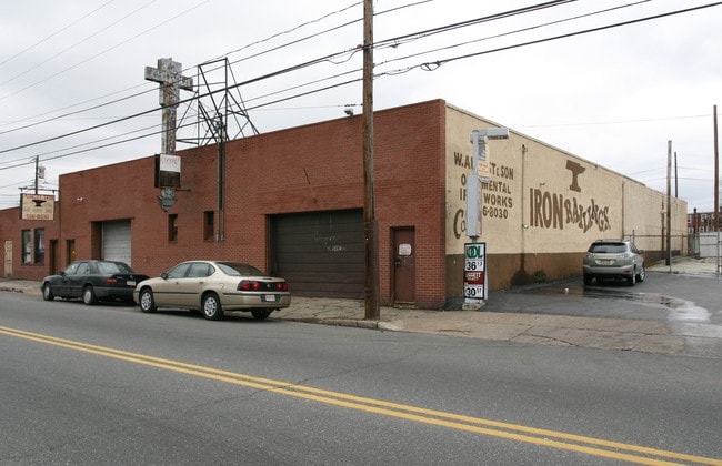

Property Detail
0 Macdade Blvd
14-00-01699-01
1 STY SHOP 70 X 82
Lightindustrial
DELAWARE
B and X Area of moderate flood hazard, usually the area between the limits of the 100-year and 500-year floods.
Pennsylvania
2024
0.13 AC
2025
Delaware County
403104
Philadelphia
5,740 SF
Philadelphia-Camden-Wilmington, PA-NJ-DE-MD
NEARBY LISTINGS FOR SALE OR LEASE
DEMOGRAPHICS near 0 Macdade Blvd
1 mile
3 mile
5 mile
2025 Total Population
31,665
275,827
660,436
2030 Population
31,993
276,164
661,468
Pop Growth 2025-2030
+ 1.04%
+ 0.12%
+ 0.16%
Average Age
38
39
38
2025 Total Households
11,597
105,598
262,306
HH Growth 2025-2030
+ 1.02%
+ 0.10%
+ 0.02%
Median Household Inc
$50,463
$55,221
$63,256
Avg Household Size
2.60
2.50
2.40
2025 Avg HH Vehicles
1.00
1.00
1.00
Median Home Value
$158,785
$180,536
$249,111
Median Year Built
1951
1948
1949
Nearby Places
Map Layers
Map Styles
 Street
 Aerial
Layers
 Traffic
 Biking
Places
Listings with unknown addresses are not visible on the map
- Restaurants
- Banks
- Shops
- Fitness
- Groceries
PUBLIC TRANSPORTATION
COMMUTER RAIL
Darby (R2 - Southeastern Pennsylvania Transportation Authority Regional Rail (SEPTA Regional Rail))
Drive
Walk
Distance
Darby (R2 - Southeastern Pennsylvania Transportation Authority Regional Rail (SEPTA Regional Rail))
4 min
20 min
1.0 mi
Lansdowne (R3 - Southeastern Pennsylvania Transportation Authority Regional Rail (SEPTA Regional Rail))
Drive
Walk
Distance
Lansdowne (R3 - Southeastern Pennsylvania Transportation Authority Regional Rail (SEPTA Regional Rail))
5 min
1.5 mi
AIRPORT
Philadelphia International
Drive
Walk
Distance
Philadelphia International
15 min
5.6 mi
Trenton Mercer
Drive
Walk
Distance
Trenton Mercer
65 min
40.5 mi
Freight Ports
Broadway Terminal - Pier 5
Drive
Walk
Distance
Broadway Terminal - Pier 5
22 min
10.9 mi
Nearby Properties
Address
Land Use
TOTAL SIZE
Lot Size
Zoning
Address
Land Use
TOTAL SIZE
Lot Size
Zoning
685,000 SF
47.69 AC
CMX3
Address
Land Use
TOTAL SIZE
Lot Size
Zoning
158,496 SF
Address
Land Use
TOTAL SIZE
Lot Size
Zoning
910,000 SF
70 AC
I2
Address
Land Use
TOTAL SIZE
Lot Size
Zoning
488,254 SF
31.56 AC
I2
Address
Land Use
TOTAL SIZE
Lot Size
Zoning
448,864 SF
32.89 AC
Address
Land Use
TOTAL SIZE
Lot Size
Zoning
323,248 SF
2.90 AC
SPAIR
Address
Land Use
TOTAL SIZE
Lot Size
Zoning
180,000 SF
0.57 AC
RM4
Address
Land Use
TOTAL SIZE
Lot Size
Zoning
7.96 AC
Address
Land Use
TOTAL SIZE
Lot Size
Zoning
200,000 SF
22 AC
RMX3
Address
Land Use
TOTAL SIZE
Lot Size
Zoning
164,640 SF
0.62 AC
CMX4
Address
Land Use
TOTAL SIZE
Lot Size
Zoning
226,764 SF
5.72 AC
CMX3
Address
Land Use
TOTAL SIZE
Lot Size
Zoning
63.81 AC
I2
Address
Land Use
TOTAL SIZE
Lot Size
Zoning
6,040 SF
16.45 AC
Address
Land Use
TOTAL SIZE
Lot Size
Zoning
63.53 AC
CMX3
Address
Land Use
TOTAL SIZE
Lot Size
Zoning
25,680 SF
31.64 AC
Address
Land Use
TOTAL SIZE
Lot Size
Zoning
136,972 SF
27 AC
Address
Land Use
TOTAL SIZE
Lot Size
Zoning
33,200 SF
19.55 AC
I2
Address
Land Use
TOTAL SIZE
Lot Size
Zoning
3,600 SF
6.61 AC
SPPOA
Address
Land Use
TOTAL SIZE
Lot Size
Zoning
454,536 SF
26.63 AC
Address
Land Use
TOTAL SIZE
Lot Size
Zoning
164,184 SF
14.62 AC
I2
Address
Land Use
TOTAL SIZE
Lot Size
Zoning
96,500 SF
6.11 AC
CMX3
Address
Land Use
TOTAL SIZE
Lot Size
Zoning
363,215 SF
7.27 AC
RM1
Address
Land Use
TOTAL SIZE
Lot Size
Zoning
131,980 SF
9.17 AC
Address
Land Use
TOTAL SIZE
Lot Size
Zoning
131,200 SF
2.19 AC
RM4
Address
Land Use
TOTAL SIZE
Lot Size
Zoning
16,990 SF
221.09 AC
SPPOA
Address
Land Use
TOTAL SIZE
Lot Size
Zoning
128,453 SF
1.21 AC
ICMX
Address
Land Use
TOTAL SIZE
Lot Size
Zoning
40,572 SF
6.52 AC
Address
Land Use
TOTAL SIZE
Lot Size
Zoning
192,000 SF
6.40 AC
CMX3
Address
Land Use
TOTAL SIZE
Lot Size
Zoning
246,296 SF
10.78 AC
RM2
Address
Land Use
TOTAL SIZE
Lot Size
Zoning
246,303 SF
11 AC
RM2
The World's #1 Commercial Real Estate Marketplace
Connect with us
© 2026 CoStar Group
The information above has been obtained from sources believed reliable. While we do not doubt its accuracy we have not verified it and make no guarantee, warranty or representation about it. It is your responsibility to independently confirm its accuracy and completeness. Any projections, opinions, assumptions, or estimates used are for example only and do not represent the current or future performance of the property. The value of this transaction to you depends on tax and other factors which should be evaluated by your tax, financial, and legal advisors. You and your advisors should conduct a careful, independent investigation of the property to determine to your satisfaction the suitability of the property for your needs.