Property Record
0 Maple Rae Ln, Houston, TX 77091
This Property Is For Sale
NEARBY LISTINGS FOR SALE OR LEASE
Property Detail
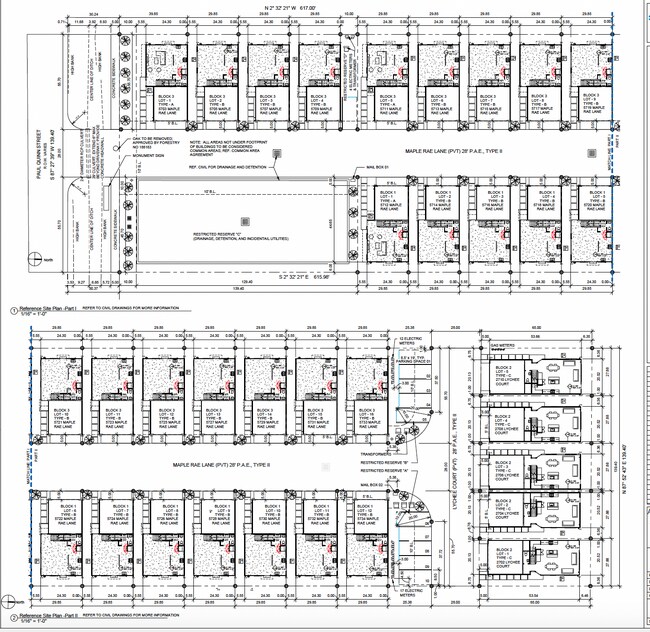
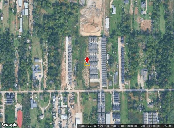
0 Maple Rae Ln
Houston
Atlas Heights
Houston-The Woodlands-Sugar Land, TX
LT 6 BLK 1 ATLAS HEIGHTS
1447950010006
Harris
Vacantlandnec
Texas
2024
6
2025
0.04 AC
531800
Acres Homes
DEMOGRAPHICS near 0 Maple Rae Ln
1 Mile
3 Mile
5 Mile
2024 Total Population
9,330
127,645
367,443
2029 Population
9,647
131,278
377,348
Pop Growth 2024-2029
+ 3.40%
+ 2.85%
+ 2.70%
Average Age
38
37
36
2024 Total Households
3,250
47,353
134,094
HH Growth 2024-2029
+ 3.32%
+ 2.86%
+ 2.86%
Median Household Inc
$43,430
$46,420
$55,895
Avg Household Size
2.70
2.60
2.70
2024 Avg HH Vehicles
2.00
2.00
2.00
Median Home Value
$290,086
$255,951
$279,880
Median Year Built
1977
1975
1978
Nearby Places
- Restaurants
- Banks
- Shops
- Fitness
- Groceries
PUBLIC TRANSPORTATION
COMMUTER RAIL
DRIVE
WALK
Distance
17 min
9.5 mi
AIRPORT
George Bush Intcntl/Houston
DRIVE
WALK
Distance
George Bush Intcntl/Houston
26 min
16.2 mi
William P Hobby
DRIVE
WALK
Distance
William P Hobby
38 min
22.4 mi
Freight Ports
Port of Houston
DRIVE
WALK
Distance
Port of Houston
30 min
17.9 mi
Nearby Properties
Address
Land Use
TOTAL SIZE
Lot Size
Zoning
Address
Land Use
TOTAL SIZE
Lot Size
Zoning
563,626 SF
4.71 AC
Address
Land Use
TOTAL SIZE
Lot Size
Zoning
432,691 SF
3.26 AC
Address
Land Use
TOTAL SIZE
Lot Size
Zoning
350,655 SF
16.76 AC
Address
Land Use
TOTAL SIZE
Lot Size
Zoning
443,228 SF
3.15 AC
Address
Land Use
TOTAL SIZE
Lot Size
Zoning
402,433 SF
2.77 AC
Address
Land Use
TOTAL SIZE
Lot Size
Zoning
279,452 SF
5.69 AC
Address
Land Use
TOTAL SIZE
Lot Size
Zoning
308,168 SF
21.34 AC
Address
Land Use
TOTAL SIZE
Lot Size
Zoning
198,259 SF
19.57 AC
Address
Land Use
TOTAL SIZE
Lot Size
Zoning
228,804 SF
3.28 AC
Address
Land Use
TOTAL SIZE
Lot Size
Zoning
259,716 SF
6.31 AC
Address
Land Use
TOTAL SIZE
Lot Size
Zoning
444,798 SF
17.17 AC
Address
Land Use
TOTAL SIZE
Lot Size
Zoning
336,050 SF
14.41 AC
Address
Land Use
TOTAL SIZE
Lot Size
Zoning
145,132 SF
3.69 AC
Address
Land Use
TOTAL SIZE
Lot Size
Zoning
313,158 SF
12.54 AC
Address
Land Use
TOTAL SIZE
Lot Size
Zoning
244,727 SF
10.49 AC
Address
Land Use
TOTAL SIZE
Lot Size
Zoning
217,700 SF
16.16 AC
Address
Land Use
TOTAL SIZE
Lot Size
Zoning
437,052 SF
15.90 AC
Address
Land Use
TOTAL SIZE
Lot Size
Zoning
333,616 SF
12.81 AC
Address
Land Use
TOTAL SIZE
Lot Size
Zoning
282,024 SF
13.13 AC
Address
Land Use
TOTAL SIZE
Lot Size
Zoning
200,233 SF
Address
Land Use
TOTAL SIZE
Lot Size
Zoning
194,196 SF
62.19 AC
Address
Land Use
TOTAL SIZE
Lot Size
Zoning
333,286 SF
13.95 AC
Address
Land Use
TOTAL SIZE
Lot Size
Zoning
176,505 SF
2.72 AC
Address
Land Use
TOTAL SIZE
Lot Size
Zoning
200,511 SF
9.48 AC
Address
Land Use
TOTAL SIZE
Lot Size
Zoning
143,028 SF
21.92 AC
Address
Land Use
TOTAL SIZE
Lot Size
Zoning
403,488 SF
15.07 AC
Address
Land Use
TOTAL SIZE
Lot Size
Zoning
265,572 SF
20.64 AC
Address
Land Use
TOTAL SIZE
Lot Size
Zoning
239,721 SF
8.98 AC
Address
Land Use
TOTAL SIZE
Lot Size
Zoning
228,344 SF
7.25 AC
Address
Land Use
TOTAL SIZE
Lot Size
Zoning
139,548 SF
12.71 AC
The World's #1 Commercial Real Estate Marketplace
Connect with us
© 2025 CoStar Group
The information above has been obtained from sources believed reliable. While we do not doubt its accuracy we have not verified it and make no guarantee, warranty or representation about it. It is your responsibility to independently confirm its accuracy and completeness. Any projections, opinions, assumptions, or estimates used are for example only and do not represent the current or future performance of the property. The value of this transaction to you depends on tax and other factors which should be evaluated by your tax, financial, and legal advisors. You and your advisors should conduct a careful, independent investigation of the property to determine to your satisfaction the suitability of the property for your needs.