Property Record
Leadership Pkwy, Reno, NV 89503
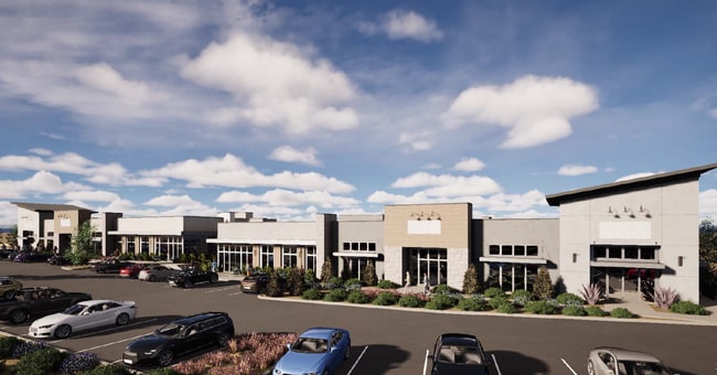
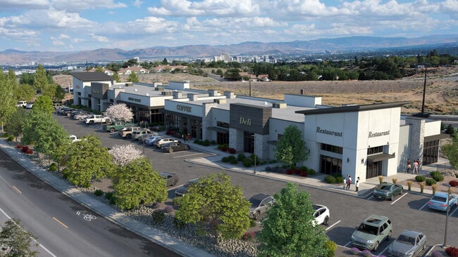
Current Lease Availabilities
General Retail LEASE
Negotiable
1,200 - 18,000 SF
NEARBY LISTINGS FOR SALE OR LEASE
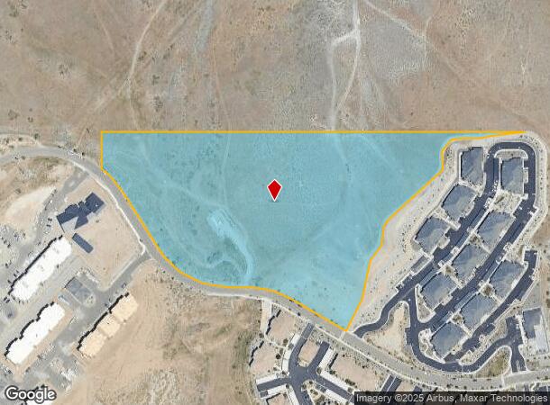
Property Detail
Leadership Pkwy
Reno/Sparks
Villas Ii @ Keystone Canyon
Reno, NV
VILLAS II @ KEYSTONE CANYON PAR 1
001-601-01
Washoe
Commercialacreage
Nevada
2024
par.1
2025
11.43 AC
002500
Northwest Reno
DEMOGRAPHICS near Leadership Pkwy
1 Mile
3 Mile
5 Mile
2024 Total Population
6,940
83,028
201,797
2029 Population
7,413
88,149
215,137
Pop Growth 2024-2029
+ 6.82%
+ 6.17%
+ 6.61%
Average Age
40
38
39
2024 Total Households
2,706
34,631
82,641
HH Growth 2024-2029
+ 7.06%
+ 6.36%
+ 6.78%
Median Household Inc
$92,171
$67,094
$68,925
Avg Household Size
2.50
2.20
2.30
2024 Avg HH Vehicles
2.00
2.00
2.00
Median Home Value
$476,768
$509,807
$517,347
Median Year Built
1986
1987
1985
Nearby Places
- Restaurants
- Banks
- Shops
- Fitness
- Groceries
PUBLIC TRANSPORTATION
COMMUTER RAIL
Reno (California Zephyr - Amtrak)
DRIVE
WALK
Distance
Reno (California Zephyr - Amtrak)
9 min
3.8 mi
AIRPORT
Reno/Tahoe International
DRIVE
WALK
Distance
Reno/Tahoe International
31 min
10.9 mi
Freight Ports
Port of Stockton
DRIVE
WALK
Distance
Port of Stockton
207 min
178.5 mi
Nearby Properties
Address
Land Use
TOTAL SIZE
Lot Size
Zoning
Address
Land Use
TOTAL SIZE
Lot Size
Zoning
120.45 AC
PF
Address
Land Use
TOTAL SIZE
Lot Size
Zoning
1,865,345 SF
2.75 AC
MD-ED
Address
Land Use
TOTAL SIZE
Lot Size
Zoning
55,187 SF
116.12 AC
GC
Address
Land Use
TOTAL SIZE
Lot Size
Zoning
391,195 SF
53.65 AC
PF
Address
Land Use
TOTAL SIZE
Lot Size
Zoning
507,606 SF
3.42 AC
MU
Address
Land Use
TOTAL SIZE
Lot Size
Zoning
292,461 SF
1.22 AC
MU
Address
Land Use
TOTAL SIZE
Lot Size
Zoning
501,541 SF
2.89 AC
MD-ED
Address
Land Use
TOTAL SIZE
Lot Size
Zoning
477,926 SF
54.37 AC
MF14
Address
Land Use
TOTAL SIZE
Lot Size
Zoning
378,145 SF
27.36 AC
PD
Address
Land Use
TOTAL SIZE
Lot Size
Zoning
396,810 SF
16.21 AC
PD
Address
Land Use
TOTAL SIZE
Lot Size
Zoning
189,861 SF
1.69 AC
MD-NWQ
Address
Land Use
TOTAL SIZE
Lot Size
Zoning
460,688 SF
62.55 AC
PF
Address
Land Use
TOTAL SIZE
Lot Size
Zoning
460,367 SF
1.52 AC
MD-ED
Address
Land Use
TOTAL SIZE
Lot Size
Zoning
232,156 SF
1.76 AC
MU
Address
Land Use
TOTAL SIZE
Lot Size
Zoning
306,626 SF
17.61 AC
MF14 44% /
Address
Land Use
TOTAL SIZE
Lot Size
Zoning
234,478 SF
2.93 AC
MD-ED
Address
Land Use
TOTAL SIZE
Lot Size
Zoning
342,947 SF
8.95 AC
MF30
Address
Land Use
TOTAL SIZE
Lot Size
Zoning
434,002 SF
7.64 AC
MD-NWQ
Address
Land Use
TOTAL SIZE
Lot Size
Zoning
194,000 SF
2.24 AC
MD-RD
Address
Land Use
TOTAL SIZE
Lot Size
Zoning
283,243 SF
2.02 AC
MD-UD
Address
Land Use
TOTAL SIZE
Lot Size
Zoning
587,380 SF
2.59 AC
MD-ED
Address
Land Use
TOTAL SIZE
Lot Size
Zoning
304,344 SF
10.24 AC
GC
Address
Land Use
TOTAL SIZE
Lot Size
Zoning
257,400 SF
2.71 AC
MD-ED
Address
Land Use
TOTAL SIZE
Lot Size
Zoning
100,469 SF
2.76 AC
MD-ED
Address
Land Use
TOTAL SIZE
Lot Size
Zoning
125,324 SF
2.06 AC
MD-NWQ
Address
Land Use
TOTAL SIZE
Lot Size
Zoning
310,568 SF
8.10 AC
MF30
Address
Land Use
TOTAL SIZE
Lot Size
Zoning
573,331 SF
6.52 AC
MD-ED
Address
Land Use
TOTAL SIZE
Lot Size
Zoning
209,748 SF
3.88 AC
MD-RD
Address
Land Use
TOTAL SIZE
Lot Size
Zoning
160,292 SF
1.66 AC
MF30
Address
Land Use
TOTAL SIZE
Lot Size
Zoning
305,060 SF
23.90 AC
SPD
The World's #1 Commercial Real Estate Marketplace
Connect with us
© 2025 CoStar Group
The information above has been obtained from sources believed reliable. While we do not doubt its accuracy we have not verified it and make no guarantee, warranty or representation about it. It is your responsibility to independently confirm its accuracy and completeness. Any projections, opinions, assumptions, or estimates used are for example only and do not represent the current or future performance of the property. The value of this transaction to you depends on tax and other factors which should be evaluated by your tax, financial, and legal advisors. You and your advisors should conduct a careful, independent investigation of the property to determine to your satisfaction the suitability of the property for your needs.