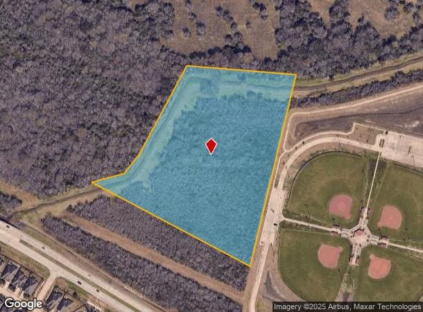
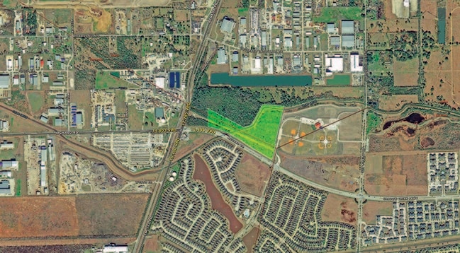
Property Record
0 Mchard Rd, Houston, TX 77047


NEARBY LISTINGS FOR SALE OR LEASE
Property Detail
0 Mchard Rd
Houston-Pasadena-The Woodlands, TX
Abst 362 S G Haynie
0430280000006
TR 1E ABST 362 S G HAYNIE
Commercialacreage
Harris
AE
Texas
48039C0010K
13.57 AC
2024
South
2025
Houston
331502
DEMOGRAPHICS near 0 Mchard Rd
1 Mile
3 Mile
5 Mile
2024 Total Population
9,212
81,860
219,175
2029 Population
10,651
89,870
240,679
Pop Growth 2024-2029
+ 15.62%
+ 9.78%
+ 9.81%
Average Age
35
35
36
2024 Total Households
3,342
26,306
70,264
HH Growth 2024-2029
+ 16.22%
+ 10.23%
+ 9.96%
Median Household Inc
$81,225
$76,956
$77,780
Avg Household Size
2.70
3.10
3.10
2024 Avg HH Vehicles
2.00
2.00
2.00
Median Home Value
$317,849
$242,601
$224,303
Median Year Built
2010
2003
2002
Nearby Places
Map Layers
Map Styles
 Street
 Aerial
- Restaurants
- Banks
- Shops
- Fitness
- Groceries
PUBLIC TRANSPORTATION
AIRPORT
William P Hobby
DRIVE
WALK
Distance
William P Hobby
26 min
13.3 mi
George Bush Intcntl/Houston
DRIVE
WALK
Distance
George Bush Intcntl/Houston
46 min
33.8 mi
Freight Ports
Port of Houston
DRIVE
WALK
Distance
Port of Houston
32 min
20.0 mi
SALE & LEASE HISTORY
LISTING DATE
SALE/LEASE

Aug 16, 2017
For Sale
Nearby Properties
Address
Land Use
TOTAL SIZE
Lot Size
Zoning
Address
Land Use
TOTAL SIZE
Lot Size
Zoning
241,351 SF
60.11 AC
Address
Land Use
TOTAL SIZE
Lot Size
Zoning
367,766 SF
43.71 AC
Address
Land Use
TOTAL SIZE
Lot Size
Zoning
567,513 SF
5.82 AC
Address
Land Use
TOTAL SIZE
Lot Size
Zoning
542,333 SF
43.95 AC
Address
Land Use
TOTAL SIZE
Lot Size
Zoning
150,275 SF
37.92 AC
Address
Land Use
TOTAL SIZE
Lot Size
Zoning
42,360 SF
13.01 AC
Address
Land Use
TOTAL SIZE
Lot Size
Zoning
679,822 SF
27.54 AC
Address
Land Use
TOTAL SIZE
Lot Size
Zoning
347,124 SF
Address
Land Use
TOTAL SIZE
Lot Size
Zoning
181,341 SF
16.73 AC
Address
Land Use
TOTAL SIZE
Lot Size
Zoning
369,539 SF
30.71 AC
Address
Land Use
TOTAL SIZE
Lot Size
Zoning
372,209 SF
17.91 AC
Address
Land Use
TOTAL SIZE
Lot Size
Zoning
460,711 SF
18.98 AC
Address
Land Use
TOTAL SIZE
Lot Size
Zoning
318,524 SF
20.44 AC
Address
Land Use
TOTAL SIZE
Lot Size
Zoning
428,639 SF
16.96 AC
Address
Land Use
TOTAL SIZE
Lot Size
Zoning
373,654 SF
16.35 AC
Address
Land Use
TOTAL SIZE
Lot Size
Zoning
670,850 SF
35.98 AC
Address
Land Use
TOTAL SIZE
Lot Size
Zoning
447,956 SF
18.42 AC
Address
Land Use
TOTAL SIZE
Lot Size
Zoning
412,375 SF
22.57 AC
Address
Land Use
TOTAL SIZE
Lot Size
Zoning
400,696 SF
18.88 AC
Address
Land Use
TOTAL SIZE
Lot Size
Zoning
354,686 SF
15.85 AC
Address
Land Use
TOTAL SIZE
Lot Size
Zoning
156,214 SF
13.50 AC
0025
Address
Land Use
TOTAL SIZE
Lot Size
Zoning
319,173 SF
7.67 AC
Address
Land Use
TOTAL SIZE
Lot Size
Zoning
350,128 SF
16.98 AC
Address
Land Use
TOTAL SIZE
Lot Size
Zoning
281,889 SF
10.84 AC
Address
Land Use
TOTAL SIZE
Lot Size
Zoning
124,254 SF
22.68 AC
0002
Address
Land Use
TOTAL SIZE
Lot Size
Zoning
62,055 SF
5.46 AC
Address
Land Use
TOTAL SIZE
Lot Size
Zoning
215,063 SF
19.13 AC
Address
Land Use
TOTAL SIZE
Lot Size
Zoning
130,498 SF
93.44 AC
Address
Land Use
TOTAL SIZE
Lot Size
Zoning
170,092 SF
17.90 AC
Address
Land Use
TOTAL SIZE
Lot Size
Zoning
117,729 SF
15.41 AC
The World's #1 Commercial Real Estate Marketplace
Connect with us
© 2026 CoStar Group
The information above has been obtained from sources believed reliable. While we do not doubt its accuracy we have not verified it and make no guarantee, warranty or representation about it. It is your responsibility to independently confirm its accuracy and completeness. Any projections, opinions, assumptions, or estimates used are for example only and do not represent the current or future performance of the property. The value of this transaction to you depends on tax and other factors which should be evaluated by your tax, financial, and legal advisors. You and your advisors should conduct a careful, independent investigation of the property to determine to your satisfaction the suitability of the property for your needs.