Property Record
Melanie Dr, Mark Twain, NV 89403
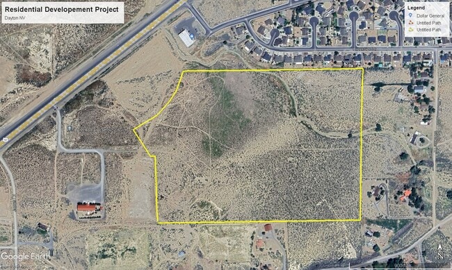


This Property Is For Sale
NEARBY LISTINGS FOR SALE OR LEASE
Property Detail
Melanie Dr
Reno, NV
PAR A-4A ADJD CHANGED FROM PARCEL #016-311-26 CREATED FROM SPLIT OF PARCEL # 016-311-30 016-311-44 016-311-43 016-311-42 016-311-41 LOT 3; FR S2 NE4 NW4; S2 NW4 NE4; PARCEL A-4 CHANGED FROM PARCEL # 016-311-44 FR S2 NE4 NW4; S2 NW4 NE4; PAR A-4 ADJ B
016-311-67
Lyon
Residentialacreage
Nevada
AO
3
32019C0291F
54.33 AC
2026
Lyon County
2025
Reno/Sparks
960302
DEMOGRAPHICS near Melanie Dr
1 Mile
3 Mile
5 Mile
2024 Total Population
2,783
12,896
17,152
2029 Population
3,039
14,141
18,747
Pop Growth 2024-2029
+ 9.20%
+ 9.65%
+ 9.30%
Average Age
44
44
44
2024 Total Households
1,051
4,962
6,670
HH Growth 2024-2029
+ 9.23%
+ 9.57%
+ 9.22%
Median Household Inc
$91,564
$81,508
$79,514
Avg Household Size
2.70
2.60
2.50
2024 Avg HH Vehicles
3.00
3.00
2.00
Median Home Value
$344,845
$351,400
$356,755
Median Year Built
2000
2001
2000
Nearby Places
Map Layers
Map Styles
 Street
 Aerial
- Restaurants
- Banks
- Shops
- Fitness
- Groceries
PUBLIC TRANSPORTATION
AIRPORT
Reno/Tahoe International
DRIVE
WALK
Distance
Reno/Tahoe International
73 min
33.3 mi
Freight Ports
Port of Stockton
DRIVE
WALK
Distance
Port of Stockton
246 min
169.0 mi
Nearby Properties
Address
Land Use
TOTAL SIZE
Lot Size
Zoning
Address
Land Use
TOTAL SIZE
Lot Size
Zoning
50,495 SF
10.76 AC
E1
Address
Land Use
TOTAL SIZE
Lot Size
Zoning
9,804 SF
3.31 AC
MFR
Address
Land Use
TOTAL SIZE
Lot Size
Zoning
64,532 SF
7 AC
C2
Address
Land Use
TOTAL SIZE
Lot Size
Zoning
47,941 SF
10.33 AC
MULT
Address
Land Use
TOTAL SIZE
Lot Size
Zoning
24.60 AC
MULT
Address
Land Use
TOTAL SIZE
Lot Size
Zoning
1,579 SF
6.73 AC
C2
Address
Land Use
TOTAL SIZE
Lot Size
Zoning
9,600 SF
4.50 AC
C2
Address
Land Use
TOTAL SIZE
Lot Size
Zoning
5,760 SF
3 AC
M1
Address
Land Use
TOTAL SIZE
Lot Size
Zoning
19,934 SF
2.18 AC
C2
Address
Land Use
TOTAL SIZE
Lot Size
Zoning
35,000 SF
3 AC
M1
Address
Land Use
TOTAL SIZE
Lot Size
Zoning
3,600 SF
56.13 AC
MULT
Address
Land Use
TOTAL SIZE
Lot Size
Zoning
21,349 SF
1.82 AC
C2
Address
Land Use
TOTAL SIZE
Lot Size
Zoning
17.04 AC
C2
Address
Land Use
TOTAL SIZE
Lot Size
Zoning
672 SF
5.37 AC
C2
Address
Land Use
TOTAL SIZE
Lot Size
Zoning
29,290 SF
2 AC
M1
Address
Land Use
TOTAL SIZE
Lot Size
Zoning
18,456 SF
1.35 AC
C2
Address
Land Use
TOTAL SIZE
Lot Size
Zoning
37,200 SF
5.55 AC
M1
Address
Land Use
TOTAL SIZE
Lot Size
Zoning
15,543 SF
1.44 AC
C2
Address
Land Use
TOTAL SIZE
Lot Size
Zoning
4,644 SF
1.18 AC
C2
Address
Land Use
TOTAL SIZE
Lot Size
Zoning
4,537 SF
35.19 AC
RR2T
Address
Land Use
TOTAL SIZE
Lot Size
Zoning
12.39 AC
C2
Address
Land Use
TOTAL SIZE
Lot Size
Zoning
1,620 SF
2.81 AC
C2
Address
Land Use
TOTAL SIZE
Lot Size
Zoning
5.67 AC
C2
Address
Land Use
TOTAL SIZE
Lot Size
Zoning
7,380 SF
1.07 AC
MULT
Address
Land Use
TOTAL SIZE
Lot Size
Zoning
8.86 AC
MULT
Address
Land Use
TOTAL SIZE
Lot Size
Zoning
2,400 SF
3.01 AC
C2
Address
Land Use
TOTAL SIZE
Lot Size
Zoning
5,250 SF
2.15 AC
M1
Address
Land Use
TOTAL SIZE
Lot Size
Zoning
7,771 SF
1.21 AC
C2
Address
Land Use
TOTAL SIZE
Lot Size
Zoning
10,125 SF
2.03 AC
C2
Address
Land Use
TOTAL SIZE
Lot Size
Zoning
230.76 AC
MULT
The World's #1 Commercial Real Estate Marketplace
Connect with us
© 2026 CoStar Group
The information above has been obtained from sources believed reliable. While we do not doubt its accuracy we have not verified it and make no guarantee, warranty or representation about it. It is your responsibility to independently confirm its accuracy and completeness. Any projections, opinions, assumptions, or estimates used are for example only and do not represent the current or future performance of the property. The value of this transaction to you depends on tax and other factors which should be evaluated by your tax, financial, and legal advisors. You and your advisors should conduct a careful, independent investigation of the property to determine to your satisfaction the suitability of the property for your needs.