Property Record
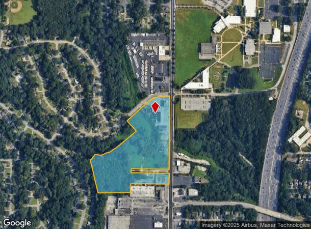
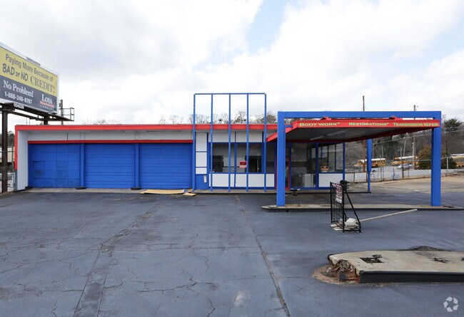
1735 Metropolitan Pky Sw, Atlanta, GA 30315

NEARBY LISTINGS FOR SALE OR LEASE
Property Detail
1735 Metropolitan Pky Sw
14-0104-0005-053-0
Stewart Ave
Storebuilding
KA 1735 STEWART AVE.RETAIL CTR. KA CODE RED
X
Fulton
13121C0358F
Georgia
2024
4.73 AC
2025
College Park/SW Atl
006500
Atlanta
26,872 SF
Atlanta-Sandy Springs-Roswell, GA
DEMOGRAPHICS near 1735 Metropolitan Pky Sw
1 Mile
3 Mile
5 Mile
2024 Total Population
9,926
108,271
274,030
2029 Population
10,278
113,321
286,020
Pop Growth 2024-2029
+ 3.55%
+ 4.66%
+ 4.38%
Average Age
39
37
37
2024 Total Households
4,305
44,338
116,866
HH Growth 2024-2029
+ 3.74%
+ 4.87%
+ 4.69%
Median Household Inc
$52,411
$41,824
$55,963
Avg Household Size
2.20
2.20
2.10
2024 Avg HH Vehicles
1.00
1.00
1.00
Median Home Value
$241,472
$269,111
$305,814
Median Year Built
1958
1968
1975
Nearby Places
- Restaurants
- Banks
- Shops
- Fitness
- Groceries
PUBLIC TRANSPORTATION
COMMUTER RAIL
DRIVE
WALK
Distance
14 min
8.2 mi
AIRPORT
Hartsfield - Jackson Atlanta International
DRIVE
WALK
Distance
Hartsfield - Jackson Atlanta International
12 min
6.2 mi
SALE & LEASE HISTORY
LISTING DATE
SALE/LEASE

Feb 16, 2021
For Lease
Nearby Properties
Address
Land Use
TOTAL SIZE
Lot Size
Zoning
Address
Land Use
TOTAL SIZE
Lot Size
Zoning
11.74 AC
I1
Address
Land Use
TOTAL SIZE
Lot Size
Zoning
7 AC
C3
Address
Land Use
TOTAL SIZE
Lot Size
Zoning
34 AC
OI
Address
Land Use
TOTAL SIZE
Lot Size
Zoning
498,515 SF
3.41 AC
C1
Address
Land Use
TOTAL SIZE
Lot Size
Zoning
595,658 SF
4.09 AC
I1
Address
Land Use
TOTAL SIZE
Lot Size
Zoning
94.93 AC
R5
Address
Land Use
TOTAL SIZE
Lot Size
Zoning
469,344 SF
3.62 AC
C3
Address
Land Use
TOTAL SIZE
Lot Size
Zoning
436,143 SF
2.90 AC
I1
Address
Land Use
TOTAL SIZE
Lot Size
Zoning
330,125 SF
7.16 AC
I1
Address
Land Use
TOTAL SIZE
Lot Size
Zoning
541,508 SF
110.88 AC
I1
Address
Land Use
TOTAL SIZE
Lot Size
Zoning
283,235 SF
5 AC
RG4
Address
Land Use
TOTAL SIZE
Lot Size
Zoning
828,718 SF
2.60 AC
I1
Address
Land Use
TOTAL SIZE
Lot Size
Zoning
5.34 AC
SPI1
Address
Land Use
TOTAL SIZE
Lot Size
Zoning
1,128,762 SF
10.39 AC
I2
Address
Land Use
TOTAL SIZE
Lot Size
Zoning
857,294 SF
101.10 AC
I1
Address
Land Use
TOTAL SIZE
Lot Size
Zoning
293,935 SF
8.47 AC
I2
Address
Land Use
TOTAL SIZE
Lot Size
Zoning
318,300 SF
4.60 AC
I1
Address
Land Use
TOTAL SIZE
Lot Size
Zoning
3,411,710 SF
25.97 AC
RG3
Address
Land Use
TOTAL SIZE
Lot Size
Zoning
0.49 AC
SPI1
Address
Land Use
TOTAL SIZE
Lot Size
Zoning
479,441 SF
0.36 AC
SPI1
Address
Land Use
TOTAL SIZE
Lot Size
Zoning
425,270 SF
201.84 AC
I1
Address
Land Use
TOTAL SIZE
Lot Size
Zoning
6.12 AC
OI
Address
Land Use
TOTAL SIZE
Lot Size
Zoning
191,217 SF
1.63 AC
RG3
Address
Land Use
TOTAL SIZE
Lot Size
Zoning
5.51 AC
OI
Address
Land Use
TOTAL SIZE
Lot Size
Zoning
396,330 SF
7.02 AC
RG3
Address
Land Use
TOTAL SIZE
Lot Size
Zoning
1,170,962 SF
38.32 AC
C3
Address
Land Use
TOTAL SIZE
Lot Size
Zoning
313,734 SF
22.60 AC
R5
Address
Land Use
TOTAL SIZE
Lot Size
Zoning
0.18 AC
SPI1
Address
Land Use
TOTAL SIZE
Lot Size
Zoning
563,256 SF
22.69 AC
I1
Address
Land Use
TOTAL SIZE
Lot Size
Zoning
7.65 AC
R5
The World's #1 Commercial Real Estate Marketplace
Connect with us
© 2025 CoStar Group
The information above has been obtained from sources believed reliable. While we do not doubt its accuracy we have not verified it and make no guarantee, warranty or representation about it. It is your responsibility to independently confirm its accuracy and completeness. Any projections, opinions, assumptions, or estimates used are for example only and do not represent the current or future performance of the property. The value of this transaction to you depends on tax and other factors which should be evaluated by your tax, financial, and legal advisors. You and your advisors should conduct a careful, independent investigation of the property to determine to your satisfaction the suitability of the property for your needs.