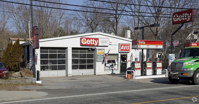
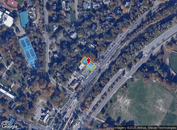
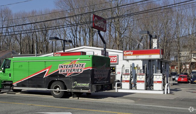
Property Record
0 N Ctry Rd, Stony Brook, NY 11790
NEARBY LISTINGS FOR SALE OR LEASE
Property Detail
0 N Ctry Rd
Nassau County-Suffolk County, NY
Beachcrest
0200-175-00-02-00-016-000
BEACHCREST 634 BA 12 TO 14 INC
Servicestation
Suffolk
X
New York
36103C0367H
16
2024
0.26 AC
2024
Central Suffolk
158012
Long Island (New York)
DEMOGRAPHICS near 0 N Ctry Rd
1 Mile
3 Mile
5 Mile
2024 Total Population
14,821
46,049
125,455
2029 Population
14,650
45,426
124,034
Pop Growth 2024-2029
(1.15%)
(1.35%)
(1.13%)
Average Age
29
39
41
2024 Total Households
1,596
11,854
39,326
HH Growth 2024-2029
(1.82%)
(1.76%)
(1.35%)
Median Household Inc
$163,028
$157,215
$128,947
Avg Household Size
2.80
2.80
2.80
2024 Avg HH Vehicles
2.00
2.00
2.00
Median Home Value
$688,123
$644,854
$544,373
Median Year Built
1960
1967
1969
Nearby Places
- Restaurants
- Banks
- Shops
- Fitness
- Groceries
PUBLIC TRANSPORTATION
TRANSIT/SUBWAY
Stony Brook Station (Port Jefferson Branch - Long Island Rail Road)
DRIVE
WALK
Distance
Stony Brook Station (Port Jefferson Branch - Long Island Rail Road)
7 min
6 min
0.3 mi
COMMUTER RAIL
Stony Brook Station (Port Jefferson Branch - Long Island Rail Road)
DRIVE
WALK
Distance
Stony Brook Station (Port Jefferson Branch - Long Island Rail Road)
6 min
4 min
0.2 mi
St James Station (Port Jefferson Branch - Long Island Rail Road)
DRIVE
WALK
Distance
St James Station (Port Jefferson Branch - Long Island Rail Road)
9 min
3.8 mi
AIRPORT
Long Island MacArthur
DRIVE
WALK
Distance
Long Island MacArthur
27 min
13.7 mi
Tweed/New Haven
DRIVE
WALK
Distance
Tweed/New Haven
120 min
43.9 mi
Freight Ports
Port of New Haven
DRIVE
WALK
Distance
Port of New Haven
115 min
41.1 mi
Nearby Properties
Address
Land Use
TOTAL SIZE
Lot Size
Zoning
Address
Land Use
TOTAL SIZE
Lot Size
Zoning
Address
Land Use
TOTAL SIZE
Lot Size
Zoning
200 AC
Address
Land Use
TOTAL SIZE
Lot Size
Zoning
Address
Land Use
TOTAL SIZE
Lot Size
Zoning
1.55 AC
Address
Land Use
TOTAL SIZE
Lot Size
Zoning
39.56 AC
Address
Land Use
TOTAL SIZE
Lot Size
Zoning
Address
Land Use
TOTAL SIZE
Lot Size
Zoning
36.82 AC
Address
Land Use
TOTAL SIZE
Lot Size
Zoning
Address
Land Use
TOTAL SIZE
Lot Size
Zoning
71.46 AC
Address
Land Use
TOTAL SIZE
Lot Size
Zoning
28.20 AC
Address
Land Use
TOTAL SIZE
Lot Size
Zoning
18.80 AC
Address
Land Use
TOTAL SIZE
Lot Size
Zoning
31.50 AC
Address
Land Use
TOTAL SIZE
Lot Size
Zoning
64.80 AC
Address
Land Use
TOTAL SIZE
Lot Size
Zoning
17.50 AC
Address
Land Use
TOTAL SIZE
Lot Size
Zoning
20.04 AC
Address
Land Use
TOTAL SIZE
Lot Size
Zoning
Address
Land Use
TOTAL SIZE
Lot Size
Zoning
Address
Land Use
TOTAL SIZE
Lot Size
Zoning
927.10 AC
Address
Land Use
TOTAL SIZE
Lot Size
Zoning
64.60 AC
Address
Land Use
TOTAL SIZE
Lot Size
Zoning
Address
Land Use
TOTAL SIZE
Lot Size
Zoning
Address
Land Use
TOTAL SIZE
Lot Size
Zoning
Address
Land Use
TOTAL SIZE
Lot Size
Zoning
3.11 AC
Address
Land Use
TOTAL SIZE
Lot Size
Zoning
31.80 AC
Address
Land Use
TOTAL SIZE
Lot Size
Zoning
Address
Land Use
TOTAL SIZE
Lot Size
Zoning
Address
Land Use
TOTAL SIZE
Lot Size
Zoning
Address
Land Use
TOTAL SIZE
Lot Size
Zoning
Address
Land Use
TOTAL SIZE
Lot Size
Zoning
13.31 AC
Address
Land Use
TOTAL SIZE
Lot Size
Zoning
3.70 AC
The World's #1 Commercial Real Estate Marketplace
Connect with us
© 2025 CoStar Group
The information above has been obtained from sources believed reliable. While we do not doubt its accuracy we have not verified it and make no guarantee, warranty or representation about it. It is your responsibility to independently confirm its accuracy and completeness. Any projections, opinions, assumptions, or estimates used are for example only and do not represent the current or future performance of the property. The value of this transaction to you depends on tax and other factors which should be evaluated by your tax, financial, and legal advisors. You and your advisors should conduct a careful, independent investigation of the property to determine to your satisfaction the suitability of the property for your needs.