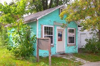
Property Record
0 N Findlay St, Haskins, OH 43525

NEARBY LISTINGS FOR SALE OR LEASE
-
-
View all Haskins listings for sale on LoopNet.com
Property Detail
0 N Findlay St
Toledo, OH
Village/Haskins
J39-610-220306041000
INLOT 146
Commercialnec
Wood
X
Ohio
39173C0150D
146
2023
0.03 AC
2024
Perrysburg/Northwood
021200
Toledo
DEMOGRAPHICS near 0 N Findlay St
1 Mile
3 Mile
5 Mile
2024 Total Population
944
5,205
22,396
2029 Population
937
5,133
22,671
Pop Growth 2024-2029
(0.74%)
(1.38%)
+ 1.23%
Average Age
39
42
40
2024 Total Households
346
2,010
8,311
HH Growth 2024-2029
(0.58%)
(1.54%)
+ 1.00%
Median Household Inc
$79,500
$89,251
$101,254
Avg Household Size
2.70
2.50
2.70
2024 Avg HH Vehicles
2.00
2.00
2.00
Median Home Value
$269,801
$239,765
$267,022
Median Year Built
1999
1976
1996
Nearby Places
Map Layers
Map Styles
 Street
 Aerial
- Restaurants
- Banks
- Shops
- Fitness
- Groceries
PUBLIC TRANSPORTATION
AIRPORT
Eugene F Kranz Toledo Express
DRIVE
WALK
Distance
Eugene F Kranz Toledo Express
30 min
13.7 mi
Freight Ports
DRIVE
WALK
Distance
39 min
23.3 mi
Nearby Properties
Address
Land Use
TOTAL SIZE
Lot Size
Zoning
Address
Land Use
TOTAL SIZE
Lot Size
Zoning
Address
Land Use
TOTAL SIZE
Lot Size
Zoning
50,400 SF
124.25 AC
39-SUP
Address
Land Use
TOTAL SIZE
Lot Size
Zoning
4.91 AC
39-M1
Address
Land Use
TOTAL SIZE
Lot Size
Zoning
87,356 SF
15.39 AC
39-SUP
Address
Land Use
TOTAL SIZE
Lot Size
Zoning
39,981 SF
5.50 AC
39-SUP
Address
Land Use
TOTAL SIZE
Lot Size
Zoning
7.45 AC
39-M1
Address
Land Use
TOTAL SIZE
Lot Size
Zoning
65,820 SF
4.91 AC
39-M1
Address
Land Use
TOTAL SIZE
Lot Size
Zoning
66,000 SF
5.19 AC
39-M1
Address
Land Use
TOTAL SIZE
Lot Size
Zoning
201.28 AC
Address
Land Use
TOTAL SIZE
Lot Size
Zoning
6,966 SF
118.50 AC
Address
Land Use
TOTAL SIZE
Lot Size
Zoning
45,176 SF
7.45 AC
39-M1
Address
Land Use
TOTAL SIZE
Lot Size
Zoning
20,160 SF
2 AC
39-R3
Address
Land Use
TOTAL SIZE
Lot Size
Zoning
28,143 SF
5 AC
39-R1
Address
Land Use
TOTAL SIZE
Lot Size
Zoning
77,840 SF
12.18 AC
Address
Land Use
TOTAL SIZE
Lot Size
Zoning
21,278 SF
13.57 AC
39-SUP
Address
Land Use
TOTAL SIZE
Lot Size
Zoning
46,895 SF
8.88 AC
39-M1
Address
Land Use
TOTAL SIZE
Lot Size
Zoning
14,497 SF
162.61 AC
Address
Land Use
TOTAL SIZE
Lot Size
Zoning
32.75 AC
Address
Land Use
TOTAL SIZE
Lot Size
Zoning
11,727 SF
0.23 AC
39-P1
Address
Land Use
TOTAL SIZE
Lot Size
Zoning
3,024 SF
212.11 AC
Address
Land Use
TOTAL SIZE
Lot Size
Zoning
23,955 SF
5.24 AC
39-M2
Address
Land Use
TOTAL SIZE
Lot Size
Zoning
26,400 SF
2.47 AC
39-M1
Address
Land Use
TOTAL SIZE
Lot Size
Zoning
Address
Land Use
TOTAL SIZE
Lot Size
Zoning
109.08 AC
Address
Land Use
TOTAL SIZE
Lot Size
Zoning
3,530 SF
113.64 AC
Address
Land Use
TOTAL SIZE
Lot Size
Zoning
3,404 SF
136.04 AC
Address
Land Use
TOTAL SIZE
Lot Size
Zoning
32,776 SF
4.30 AC
39-M1
Address
Land Use
TOTAL SIZE
Lot Size
Zoning
10,120 SF
5 AC
Address
Land Use
TOTAL SIZE
Lot Size
Zoning
14,563 SF
0.79 AC
39-M1
Address
Land Use
TOTAL SIZE
Lot Size
Zoning
3,436 SF
79.68 AC
The World's #1 Commercial Real Estate Marketplace
Connect with us
© 2025 CoStar Group
The information above has been obtained from sources believed reliable. While we do not doubt its accuracy we have not verified it and make no guarantee, warranty or representation about it. It is your responsibility to independently confirm its accuracy and completeness. Any projections, opinions, assumptions, or estimates used are for example only and do not represent the current or future performance of the property. The value of this transaction to you depends on tax and other factors which should be evaluated by your tax, financial, and legal advisors. You and your advisors should conduct a careful, independent investigation of the property to determine to your satisfaction the suitability of the property for your needs.