Property Record
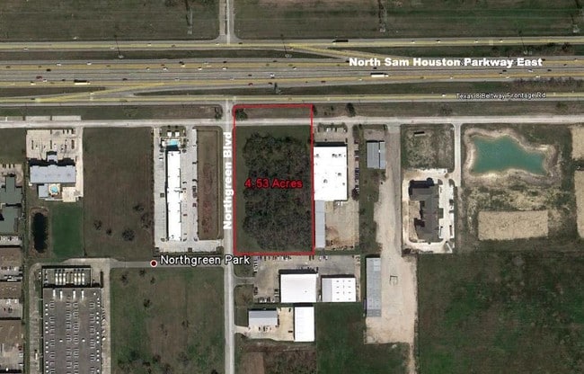
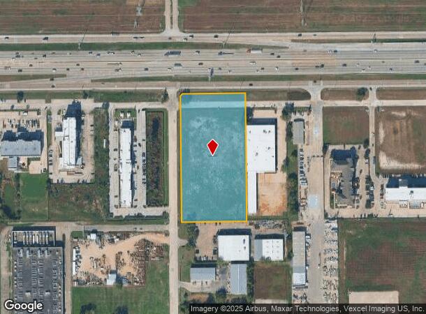
0 N Sam Houston Pkwy E, Houston, TX 77032
NEARBY LISTINGS FOR SALE OR LEASE
Property Detail
0 N Sam Houston Pkwy E
Houston-Pasadena-The Woodlands, TX
Northgreen Park
1147240000009
RES C2 NORTHGREEN PARK
Commercialacreage
Harris
AE
Texas
48201C0480M
4.53 AC
2024
Greenspoint/IAH
2025
Houston
241503
DEMOGRAPHICS near 0 N Sam Houston Pkwy E
1 Mile
3 Mile
5 Mile
2024 Total Population
3,987
66,781
192,647
2029 Population
4,091
68,007
195,538
Pop Growth 2024-2029
+ 2.61%
+ 1.84%
+ 1.50%
Average Age
33
32
33
2024 Total Households
1,198
21,442
59,007
HH Growth 2024-2029
+ 2.50%
+ 1.97%
+ 1.56%
Median Household Inc
$44,975
$35,141
$37,564
Avg Household Size
3.20
3.00
3.20
2024 Avg HH Vehicles
2.00
2.00
2.00
Median Home Value
$132,010
$129,501
$138,407
Median Year Built
1987
1980
1980
Nearby Places
Map Layers
Map Styles
 Street
 Aerial
- Restaurants
- Banks
- Shops
- Fitness
- Groceries
PUBLIC TRANSPORTATION
AIRPORT
George Bush Intcntl/Houston
DRIVE
WALK
Distance
George Bush Intcntl/Houston
8 min
5.0 mi
William P Hobby
DRIVE
WALK
Distance
William P Hobby
44 min
27.5 mi
Freight Ports
Port of Houston
DRIVE
WALK
Distance
Port of Houston
32 min
21.4 mi
Nearby Properties
Address
Land Use
TOTAL SIZE
Lot Size
Zoning
Address
Land Use
TOTAL SIZE
Lot Size
Zoning
1,213,044 SF
69.99 AC
Address
Land Use
TOTAL SIZE
Lot Size
Zoning
1,767,053 SF
88.85 AC
Address
Land Use
TOTAL SIZE
Lot Size
Zoning
785,390 SF
66.02 AC
Address
Land Use
TOTAL SIZE
Lot Size
Zoning
621,700 SF
67.57 AC
Address
Land Use
TOTAL SIZE
Lot Size
Zoning
704,105 SF
40.72 AC
Address
Land Use
TOTAL SIZE
Lot Size
Zoning
657,500 SF
36.24 AC
Address
Land Use
TOTAL SIZE
Lot Size
Zoning
500,000 SF
24.58 AC
Address
Land Use
TOTAL SIZE
Lot Size
Zoning
502,325 SF
25.13 AC
Address
Land Use
TOTAL SIZE
Lot Size
Zoning
523,480 SF
29.22 AC
Address
Land Use
TOTAL SIZE
Lot Size
Zoning
379,570 SF
30.12 AC
Address
Land Use
TOTAL SIZE
Lot Size
Zoning
431,400 SF
30.88 AC
Address
Land Use
TOTAL SIZE
Lot Size
Zoning
368,632 SF
20.06 AC
Address
Land Use
TOTAL SIZE
Lot Size
Zoning
338,700 SF
22.99 AC
Address
Land Use
TOTAL SIZE
Lot Size
Zoning
241,625 SF
11.10 AC
Address
Land Use
TOTAL SIZE
Lot Size
Zoning
394,784 SF
22.47 AC
Address
Land Use
TOTAL SIZE
Lot Size
Zoning
350,500 SF
17.71 AC
Address
Land Use
TOTAL SIZE
Lot Size
Zoning
353,600 SF
23.45 AC
Address
Land Use
TOTAL SIZE
Lot Size
Zoning
361,919 SF
23.59 AC
Address
Land Use
TOTAL SIZE
Lot Size
Zoning
448,760 SF
8.46 AC
Address
Land Use
TOTAL SIZE
Lot Size
Zoning
423,730 SF
5.91 AC
Address
Land Use
TOTAL SIZE
Lot Size
Zoning
291,656 SF
18.94 AC
Address
Land Use
TOTAL SIZE
Lot Size
Zoning
57,551 SF
49.71 AC
Address
Land Use
TOTAL SIZE
Lot Size
Zoning
257,000 SF
13.34 AC
Address
Land Use
TOTAL SIZE
Lot Size
Zoning
288,525 SF
17.66 AC
Address
Land Use
TOTAL SIZE
Lot Size
Zoning
597,462 SF
42.07 AC
Address
Land Use
TOTAL SIZE
Lot Size
Zoning
227,400 SF
19.37 AC
Address
Land Use
TOTAL SIZE
Lot Size
Zoning
383,451 SF
15.98 AC
Address
Land Use
TOTAL SIZE
Lot Size
Zoning
251,812 SF
12.22 AC
Address
Land Use
TOTAL SIZE
Lot Size
Zoning
264,300 SF
15.89 AC
Address
Land Use
TOTAL SIZE
Lot Size
Zoning
244,864 SF
12.30 AC
The World's #1 Commercial Real Estate Marketplace
Connect with us
© 2026 CoStar Group
The information above has been obtained from sources believed reliable. While we do not doubt its accuracy we have not verified it and make no guarantee, warranty or representation about it. It is your responsibility to independently confirm its accuracy and completeness. Any projections, opinions, assumptions, or estimates used are for example only and do not represent the current or future performance of the property. The value of this transaction to you depends on tax and other factors which should be evaluated by your tax, financial, and legal advisors. You and your advisors should conduct a careful, independent investigation of the property to determine to your satisfaction the suitability of the property for your needs.