Property Record
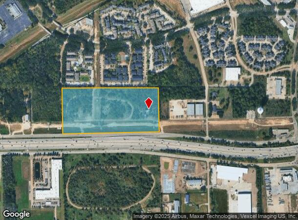
0 N Sam Houston Pkwy W, Houston, TX 77038
This Property Is For Sale
NEARBY LISTINGS FOR SALE OR LEASE
-
-
-
-
-
-
No Photo
-
-
View all Houston listings for sale on LoopNet.com
Property Detail
0 N Sam Houston Pkwy W
Houston-The Woodlands-Sugar Land, TX
Abst 1453 Wcrr Co Sec 16
0472250000011
.0833 U/D INT IN TR 2 (20.276 AC) ABST 1453 WCRR CO SEC 16 BLK 4
Agriculturalland
Harris
X
Texas
48201C0455L
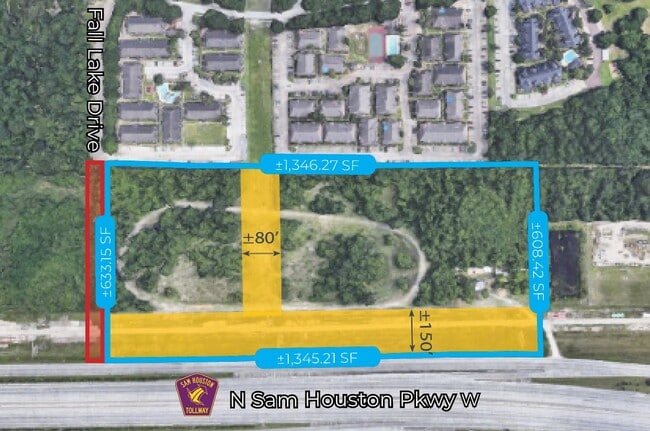
1.69 AC
2024
Greenspoint/N Belt West
2025
Houston
533702
DEMOGRAPHICS near 0 N Sam Houston Pkwy W
1 Mile
3 Mile
5 Mile
2024 Total Population
7,595
125,859
310,460
2029 Population
7,738
127,643
314,575
Pop Growth 2024-2029
+ 1.88%
+ 1.42%
+ 1.33%
Average Age
33
33
34
2024 Total Households
2,602
39,885
98,080
HH Growth 2024-2029
+ 1.96%
+ 1.49%
+ 1.41%
Median Household Inc
$39,315
$41,249
$45,264
Avg Household Size
2.80
3.10
3.10
2024 Avg HH Vehicles
2.00
2.00
2.00
Median Home Value
$149,380
$159,751
$161,964
Median Year Built
1986
1985
1985
Nearby Places
- Restaurants
- Banks
- Shops
- Fitness
- Groceries
PUBLIC TRANSPORTATION
AIRPORT
George Bush Intcntl/Houston
DRIVE
WALK
Distance
George Bush Intcntl/Houston
15 min
11.5 mi
William P Hobby
DRIVE
WALK
Distance
William P Hobby
45 min
29.1 mi
Freight Ports
Port of Houston
DRIVE
WALK
Distance
Port of Houston
36 min
24.8 mi
Nearby Properties
Address
Land Use
TOTAL SIZE
Lot Size
Zoning
Address
Land Use
TOTAL SIZE
Lot Size
Zoning
858,420 SF
60.71 AC
Address
Land Use
TOTAL SIZE
Lot Size
Zoning
145.62 AC
Address
Land Use
TOTAL SIZE
Lot Size
Zoning
739,141 SF
54 AC
Address
Land Use
TOTAL SIZE
Lot Size
Zoning
413,178 SF
21.45 AC
Address
Land Use
TOTAL SIZE
Lot Size
Zoning
704,105 SF
40.72 AC
Address
Land Use
TOTAL SIZE
Lot Size
Zoning
790,262 SF
50.60 AC
Address
Land Use
TOTAL SIZE
Lot Size
Zoning
614,256 SF
31.25 AC
Address
Land Use
TOTAL SIZE
Lot Size
Zoning
608,784 SF
29.08 AC
Address
Land Use
TOTAL SIZE
Lot Size
Zoning
718,600 SF
42.09 AC
Address
Land Use
TOTAL SIZE
Lot Size
Zoning
504,000 SF
32.25 AC
Address
Land Use
TOTAL SIZE
Lot Size
Zoning
424,122 SF
21.06 AC
Address
Land Use
TOTAL SIZE
Lot Size
Zoning
356,900 SF
19.38 AC
Address
Land Use
TOTAL SIZE
Lot Size
Zoning
350,500 SF
17.71 AC
Address
Land Use
TOTAL SIZE
Lot Size
Zoning
356,622 SF
18.26 AC
Address
Land Use
TOTAL SIZE
Lot Size
Zoning
125,512 SF
18.26 AC
Address
Land Use
TOTAL SIZE
Lot Size
Zoning
423,730 SF
5.91 AC
Address
Land Use
TOTAL SIZE
Lot Size
Zoning
284,476 SF
20 AC
Address
Land Use
TOTAL SIZE
Lot Size
Zoning
284,687 SF
19.66 AC
Address
Land Use
TOTAL SIZE
Lot Size
Zoning
200,123 SF
14.94 AC
Address
Land Use
TOTAL SIZE
Lot Size
Zoning
383,451 SF
15.98 AC
Address
Land Use
TOTAL SIZE
Lot Size
Zoning
240,240 SF
14.35 AC
Address
Land Use
TOTAL SIZE
Lot Size
Zoning
251,812 SF
12.22 AC
Address
Land Use
TOTAL SIZE
Lot Size
Zoning
244,864 SF
12.30 AC
Address
Land Use
TOTAL SIZE
Lot Size
Zoning
454,632 SF
18.69 AC
Address
Land Use
TOTAL SIZE
Lot Size
Zoning
208,008 SF
8.32 AC
Address
Land Use
TOTAL SIZE
Lot Size
Zoning
244,760 SF
17.20 AC
Address
Land Use
TOTAL SIZE
Lot Size
Zoning
241,946 SF
14.02 AC
Address
Land Use
TOTAL SIZE
Lot Size
Zoning
404,248 SF
16.31 AC
Address
Land Use
TOTAL SIZE
Lot Size
Zoning
379,255 SF
22.65 AC
Address
Land Use
TOTAL SIZE
Lot Size
Zoning
293,270 SF
8.29 AC
The World's #1 Commercial Real Estate Marketplace
Connect with us
© 2025 CoStar Group
The information above has been obtained from sources believed reliable. While we do not doubt its accuracy we have not verified it and make no guarantee, warranty or representation about it. It is your responsibility to independently confirm its accuracy and completeness. Any projections, opinions, assumptions, or estimates used are for example only and do not represent the current or future performance of the property. The value of this transaction to you depends on tax and other factors which should be evaluated by your tax, financial, and legal advisors. You and your advisors should conduct a careful, independent investigation of the property to determine to your satisfaction the suitability of the property for your needs.