Property Record
0 N Vandenberg Rd, , WI
Property Detail
0 N Vandenberg Rd
Green Bay, WI
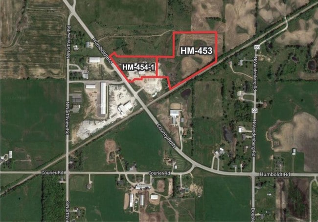
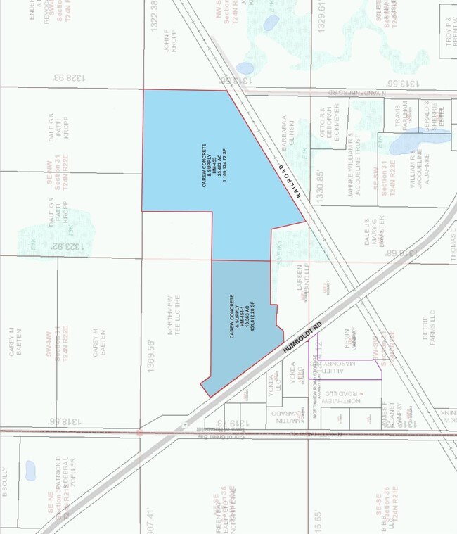
25.462 AC M/L PART OF NE1/4 SW1/4 SEC 31 T24N R22E DESC IN J24760-20
HM-453
BROWN
Commercialnec
Wisconsin
B and X Area of moderate flood hazard, usually the area between the limits of the 100-year and 500-year floods.
25.46 AC
2025
Green Bay
2025
Green Bay
002003
NEARBY LISTINGS FOR SALE OR LEASE
DEMOGRAPHICS near 0 N Vandenberg Rd
1 mile
3 mile
5 mile
2025 Total Population
249
16,038
51,427
2030 Population
252
16,656
52,447
Pop Growth 2025-2030
+ 1.20%
+ 3.85%
+ 1.98%
Average Age
45
38
39
2025 Total Households
101
5,812
20,219
HH Growth 2025-2030
+ 0.99%
+ 4.82%
+ 2.23%
Median Household Inc
$96,666
$89,534
$75,103
Avg Household Size
2.40
2.30
2.40
2025 Avg HH Vehicles
2.00
2.00
2.00
Median Home Value
$316,667
$292,778
$269,449
Median Year Built
1982
1995
1988
Nearby Places
Map Layers
Map Styles
 Street
 Aerial
Transit
 Traffic
 Biking
Places
Listings with unknown addresses are not visible on the map
- Restaurants
- Banks
- Shops
- Fitness
- Groceries
PUBLIC TRANSPORTATION
AIRPORT
Green Bay/Austin Straubel International
Drive
Walk
Distance
Green Bay/Austin Straubel International
28 min
16.7 mi
Freight Ports
Port Milwaukee
Drive
Walk
Distance
Port Milwaukee
136 min
116.0 mi
Nearby Properties
Address
Land Use
TOTAL SIZE
Lot Size
Zoning
Address
Land Use
TOTAL SIZE
Lot Size
Zoning
17,534 SF
70.63 AC
OR, R1
Address
Land Use
TOTAL SIZE
Lot Size
Zoning
27.96 AC
Address
Land Use
TOTAL SIZE
Lot Size
Zoning
1,632 SF
30.52 AC
R1
Address
Land Use
TOTAL SIZE
Lot Size
Zoning
8.11 AC
Address
Land Use
TOTAL SIZE
Lot Size
Zoning
980 SF
11.16 AC
R1
Address
Land Use
TOTAL SIZE
Lot Size
Zoning
Address
Land Use
TOTAL SIZE
Lot Size
Zoning
Address
Land Use
TOTAL SIZE
Lot Size
Zoning
9.06 AC
Address
Land Use
TOTAL SIZE
Lot Size
Zoning
10.60 AC
Address
Land Use
TOTAL SIZE
Lot Size
Zoning
14.16 AC
R1
Address
Land Use
TOTAL SIZE
Lot Size
Zoning
Address
Land Use
TOTAL SIZE
Lot Size
Zoning
1,265 SF
5.08 AC
R1
Address
Land Use
TOTAL SIZE
Lot Size
Zoning
9.10 AC
RR
Address
Land Use
TOTAL SIZE
Lot Size
Zoning
35,400 SF
4.78 AC
PI, RR
Address
Land Use
TOTAL SIZE
Lot Size
Zoning
23,085 SF
4.15 AC
RR
Address
Land Use
TOTAL SIZE
Lot Size
Zoning
18.18 AC
Address
Land Use
TOTAL SIZE
Lot Size
Zoning
3.63 AC
Address
Land Use
TOTAL SIZE
Lot Size
Zoning
1,046 SF
2.83 AC
R1
Address
Land Use
TOTAL SIZE
Lot Size
Zoning
20,147 SF
5.50 AC
RR
Address
Land Use
TOTAL SIZE
Lot Size
Zoning
4.04 AC
Address
Land Use
TOTAL SIZE
Lot Size
Zoning
1,055 SF
1.83 AC
OR, R1
Address
Land Use
TOTAL SIZE
Lot Size
Zoning
1,046 SF
6 AC
R1
Address
Land Use
TOTAL SIZE
Lot Size
Zoning
27,936 SF
2.57 AC
R3, RR
Address
Land Use
TOTAL SIZE
Lot Size
Zoning
Address
Land Use
TOTAL SIZE
Lot Size
Zoning
6.06 AC
Address
Land Use
TOTAL SIZE
Lot Size
Zoning
1,150 SF
2.20 AC
R1
Address
Land Use
TOTAL SIZE
Lot Size
Zoning
3.47 AC
Address
Land Use
TOTAL SIZE
Lot Size
Zoning
Address
Land Use
TOTAL SIZE
Lot Size
Zoning
4.82 AC
Address
Land Use
TOTAL SIZE
Lot Size
Zoning
The World's #1 Commercial Real Estate Marketplace
Connect with us
© 2026 CoStar Group
The information above has been obtained from sources believed reliable. While we do not doubt its accuracy we have not verified it and make no guarantee, warranty or representation about it. It is your responsibility to independently confirm its accuracy and completeness. Any projections, opinions, assumptions, or estimates used are for example only and do not represent the current or future performance of the property. The value of this transaction to you depends on tax and other factors which should be evaluated by your tax, financial, and legal advisors. You and your advisors should conduct a careful, independent investigation of the property to determine to your satisfaction the suitability of the property for your needs.