Property Record
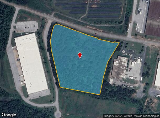
New Cut Rd, Spartanburg, SC 29303
NEARBY LISTINGS FOR SALE OR LEASE
Property Detail
New Cut Rd
Spartanburg, SC
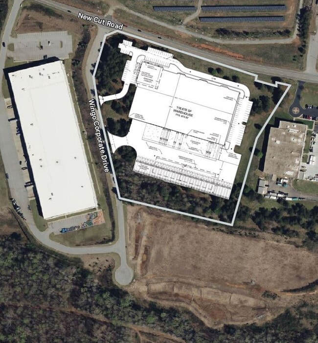
Survey For 2057656 Ontario Ltd
6-06-00-044.16
S SIDE NEW CUT RD & W OF BLACKSTOCK RD PB 131-33 PB 142-471 PB 165-229
Commercialacreage
Spartanburg
X
South Carolina
45083C0231E
10.92 AC
2024
Upper Spartanburg County
2025
Greenville/Spartanburg
021600
DEMOGRAPHICS near New Cut Rd
1 Mile
3 Mile
5 Mile
2024 Total Population
1,400
19,796
67,258
2029 Population
1,576
22,297
76,200
Pop Growth 2024-2029
+ 12.57%
+ 12.63%
+ 13.30%
Average Age
39
38
38
2024 Total Households
525
7,197
25,024
HH Growth 2024-2029
+ 12.76%
+ 12.89%
+ 13.66%
Median Household Inc
$61,339
$54,265
$57,453
Avg Household Size
2.60
2.60
2.50
2024 Avg HH Vehicles
2.00
2.00
2.00
Median Home Value
$229,629
$185,342
$186,050
Median Year Built
1991
1989
1991
Nearby Places
- Restaurants
- Banks
- Shops
- Fitness
- Groceries
PUBLIC TRANSPORTATION
COMMUTER RAIL
Spartanburg Amtrak Station (Crescent - Amtrak)
DRIVE
WALK
Distance
Spartanburg Amtrak Station (Crescent - Amtrak)
14 min
7.5 mi
AIRPORT
Greenville Spartanburg International
DRIVE
WALK
Distance
Greenville Spartanburg International
25 min
17.2 mi
Freight Ports
North Charleston Terminal
DRIVE
WALK
Distance
North Charleston Terminal
221 min
198.0 mi
SALE & LEASE HISTORY
LISTING DATE
SALE/LEASE

Aug 26, 2024
For Sale
Nearby Properties
Address
Land Use
TOTAL SIZE
Lot Size
Zoning
Address
Land Use
TOTAL SIZE
Lot Size
Zoning
4,172 SF
15.98 AC
Address
Land Use
TOTAL SIZE
Lot Size
Zoning
175,000 SF
17.70 AC
Address
Land Use
TOTAL SIZE
Lot Size
Zoning
100,000 SF
8.29 AC
Address
Land Use
TOTAL SIZE
Lot Size
Zoning
239,095 SF
22.41 AC
Address
Land Use
TOTAL SIZE
Lot Size
Zoning
128,755 SF
4.47 AC
Address
Land Use
TOTAL SIZE
Lot Size
Zoning
Address
Land Use
TOTAL SIZE
Lot Size
Zoning
64,092 SF
30.61 AC
Address
Land Use
TOTAL SIZE
Lot Size
Zoning
37.35 AC
Address
Land Use
TOTAL SIZE
Lot Size
Zoning
402,619 SF
58.63 AC
Address
Land Use
TOTAL SIZE
Lot Size
Zoning
1,092 SF
67.55 AC
Address
Land Use
TOTAL SIZE
Lot Size
Zoning
1,221,473 SF
36.50 AC
Address
Land Use
TOTAL SIZE
Lot Size
Zoning
341,895 SF
31.62 AC
Address
Land Use
TOTAL SIZE
Lot Size
Zoning
33,550 SF
3.77 AC
Address
Land Use
TOTAL SIZE
Lot Size
Zoning
41,694 SF
4.01 AC
Address
Land Use
TOTAL SIZE
Lot Size
Zoning
39.65 AC
Address
Land Use
TOTAL SIZE
Lot Size
Zoning
176,072 SF
13.72 AC
Address
Land Use
TOTAL SIZE
Lot Size
Zoning
201,900 SF
39.10 AC
Address
Land Use
TOTAL SIZE
Lot Size
Zoning
7,000 SF
3 AC
Address
Land Use
TOTAL SIZE
Lot Size
Zoning
193,279 SF
10.79 AC
Address
Land Use
TOTAL SIZE
Lot Size
Zoning
2,220 SF
14.09 AC
Address
Land Use
TOTAL SIZE
Lot Size
Zoning
39.02 AC
Address
Land Use
TOTAL SIZE
Lot Size
Zoning
102,400 SF
25.19 AC
Address
Land Use
TOTAL SIZE
Lot Size
Zoning
17,971 SF
39.35 AC
Address
Land Use
TOTAL SIZE
Lot Size
Zoning
277,152 SF
27.20 AC
Address
Land Use
TOTAL SIZE
Lot Size
Zoning
4,070 SF
0.96 AC
Address
Land Use
TOTAL SIZE
Lot Size
Zoning
7,600 SF
2.18 AC
Address
Land Use
TOTAL SIZE
Lot Size
Zoning
111,577 SF
8.23 AC
Address
Land Use
TOTAL SIZE
Lot Size
Zoning
131,113 SF
15.34 AC
Address
Land Use
TOTAL SIZE
Lot Size
Zoning
73,172 SF
0.58 AC
Address
Land Use
TOTAL SIZE
Lot Size
Zoning
2,649 SF
3.62 AC
The World's #1 Commercial Real Estate Marketplace
Connect with us
© 2025 CoStar Group
The information above has been obtained from sources believed reliable. While we do not doubt its accuracy we have not verified it and make no guarantee, warranty or representation about it. It is your responsibility to independently confirm its accuracy and completeness. Any projections, opinions, assumptions, or estimates used are for example only and do not represent the current or future performance of the property. The value of this transaction to you depends on tax and other factors which should be evaluated by your tax, financial, and legal advisors. You and your advisors should conduct a careful, independent investigation of the property to determine to your satisfaction the suitability of the property for your needs.