Property Record
N Ih 35, Elm Mott, TX 76640
NEARBY LISTINGS FOR SALE OR LEASE
Property Detail
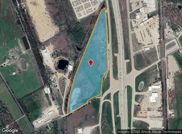
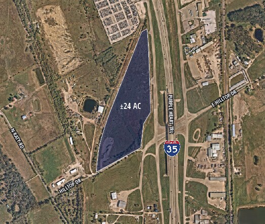
N Ih 35
Waco, TX
Holmes E W
20-045400-005801-0
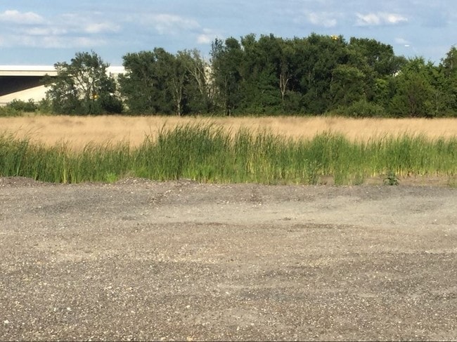
HOLMES E W TRACT 16A1 ACRES 24.02
Commercialacreage
Mclennan
A
Texas
48309C0225D
16a1
2024
24.02 AC
2025
Waco & Killeen
003401
Other Market Areas
DEMOGRAPHICS near N Ih 35
1 Mile
3 Mile
5 Mile
2024 Total Population
605
3,969
18,081
2029 Population
616
4,103
19,180
Pop Growth 2024-2029
+ 1.82%
+ 3.38%
+ 6.08%
Average Age
40
40
37
2024 Total Households
225
1,467
6,630
HH Growth 2024-2029
+ 1.78%
+ 3.48%
+ 6.29%
Median Household Inc
$64,772
$63,634
$52,955
Avg Household Size
2.60
2.60
2.50
2024 Avg HH Vehicles
2.00
2.00
2.00
Median Home Value
$159,285
$163,704
$162,927
Median Year Built
1983
1983
1980
Nearby Places
Map Layers
Map Styles
 Street
 Aerial
- Restaurants
- Banks
- Shops
- Fitness
- Groceries
PUBLIC TRANSPORTATION
AIRPORT
Waco Regional
DRIVE
WALK
Distance
Waco Regional
26 min
15.0 mi
Freight Ports
Port of Houston
DRIVE
WALK
Distance
Port of Houston
221 min
192.8 mi
SALE & LEASE HISTORY
LISTING DATE
SALE/LEASE

Sep 24, 2016
For Sale
Jul 09, 2024
For Sale
Dec 01, 2017
For Sale
Nearby Properties
Address
Land Use
TOTAL SIZE
Lot Size
Zoning
Address
Land Use
TOTAL SIZE
Lot Size
Zoning
193,246 SF
144.87 AC
R
Address
Land Use
TOTAL SIZE
Lot Size
Zoning
99,796 SF
11.13 AC
R
Address
Land Use
TOTAL SIZE
Lot Size
Zoning
11,583 SF
17 AC
Address
Land Use
TOTAL SIZE
Lot Size
Zoning
9,694 SF
34.11 AC
R
Address
Land Use
TOTAL SIZE
Lot Size
Zoning
182,614 SF
25.49 AC
C
Address
Land Use
TOTAL SIZE
Lot Size
Zoning
79,000 SF
6.09 AC
R
Address
Land Use
TOTAL SIZE
Lot Size
Zoning
40,270 SF
51.91 AC
R
Address
Land Use
TOTAL SIZE
Lot Size
Zoning
13,379 SF
8.99 AC
C
Address
Land Use
TOTAL SIZE
Lot Size
Zoning
70,675 SF
19.48 AC
C
Address
Land Use
TOTAL SIZE
Lot Size
Zoning
45,000 SF
8.01 AC
R
Address
Land Use
TOTAL SIZE
Lot Size
Zoning
82,965 SF
10.77 AC
R
Address
Land Use
TOTAL SIZE
Lot Size
Zoning
20,639 SF
11.53 AC
C
Address
Land Use
TOTAL SIZE
Lot Size
Zoning
1,800 SF
24.77 AC
C
Address
Land Use
TOTAL SIZE
Lot Size
Zoning
18.61 AC
R
Address
Land Use
TOTAL SIZE
Lot Size
Zoning
23,274 SF
5 AC
R
Address
Land Use
TOTAL SIZE
Lot Size
Zoning
4,624 SF
0.78 AC
C
Address
Land Use
TOTAL SIZE
Lot Size
Zoning
18,850 SF
21.94 AC
R
Address
Land Use
TOTAL SIZE
Lot Size
Zoning
48,790 SF
4.01 AC
C
Address
Land Use
TOTAL SIZE
Lot Size
Zoning
33,720 SF
10 AC
R
Address
Land Use
TOTAL SIZE
Lot Size
Zoning
28,700 SF
13.75 AC
C
Address
Land Use
TOTAL SIZE
Lot Size
Zoning
15,140 SF
21.74 AC
Address
Land Use
TOTAL SIZE
Lot Size
Zoning
12,952 SF
4.08 AC
R
Address
Land Use
TOTAL SIZE
Lot Size
Zoning
18,058 SF
2.80 AC
Address
Land Use
TOTAL SIZE
Lot Size
Zoning
26,102 SF
5.66 AC
Address
Land Use
TOTAL SIZE
Lot Size
Zoning
16,360 SF
58.66 AC
C
Address
Land Use
TOTAL SIZE
Lot Size
Zoning
17,500 SF
5.18 AC
C
Address
Land Use
TOTAL SIZE
Lot Size
Zoning
36,001 SF
8.82 AC
R
Address
Land Use
TOTAL SIZE
Lot Size
Zoning
9,065 SF
1.62 AC
R
Address
Land Use
TOTAL SIZE
Lot Size
Zoning
7,123 SF
14.62 AC
C
Address
Land Use
TOTAL SIZE
Lot Size
Zoning
9,344 SF
5 AC
The World's #1 Commercial Real Estate Marketplace
Connect with us
© 2025 CoStar Group
The information above has been obtained from sources believed reliable. While we do not doubt its accuracy we have not verified it and make no guarantee, warranty or representation about it. It is your responsibility to independently confirm its accuracy and completeness. Any projections, opinions, assumptions, or estimates used are for example only and do not represent the current or future performance of the property. The value of this transaction to you depends on tax and other factors which should be evaluated by your tax, financial, and legal advisors. You and your advisors should conduct a careful, independent investigation of the property to determine to your satisfaction the suitability of the property for your needs.