Property Record
N Virginia St, Reno, NV 89506
This Property Is For Sale
NEARBY LISTINGS FOR SALE OR LEASE
Property Detail
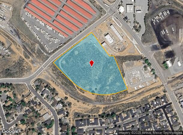
N Virginia St
Reno/Sparks
_Unspecified
Reno, NV
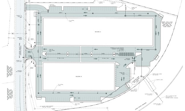
PM 5611 PAR 2
082-293-13
Washoe
Industrialacreage
Nevada
0
par.2
2026
6.08 AC
002615
North Valleys
DEMOGRAPHICS near N Virginia St
1 Mile
3 Mile
5 Mile
2024 Total Population
4,966
30,810
145,055
2029 Population
5,167
33,072
152,638
Pop Growth 2024-2029
+ 4.05%
+ 7.34%
+ 5.23%
Average Age
40
38
37
2024 Total Households
1,799
10,661
52,626
HH Growth 2024-2029
+ 4.11%
+ 7.34%
+ 5.36%
Median Household Inc
$74,493
$78,032
$64,504
Avg Household Size
2.70
2.70
2.60
2024 Avg HH Vehicles
2.00
2.00
2.00
Median Home Value
$458,124
$408,329
$374,432
Median Year Built
1995
2001
1990
Nearby Places
Map Layers
Map Styles
 Street
 Aerial
- Restaurants
- Banks
- Shops
- Fitness
- Groceries
PUBLIC TRANSPORTATION
COMMUTER RAIL
Reno (California Zephyr - Amtrak)
DRIVE
WALK
Distance
Reno (California Zephyr - Amtrak)
10 min
7.4 mi
AIRPORT
Reno/Tahoe International
DRIVE
WALK
Distance
Reno/Tahoe International
28 min
11.2 mi
Freight Ports
Port of Stockton
DRIVE
WALK
Distance
Port of Stockton
214 min
185.5 mi
Nearby Properties
Address
Land Use
TOTAL SIZE
Lot Size
Zoning
Address
Land Use
TOTAL SIZE
Lot Size
Zoning
391,195 SF
53.65 AC
PF
Address
Land Use
TOTAL SIZE
Lot Size
Zoning
371,855 SF
39.61 AC
MF14
Address
Land Use
TOTAL SIZE
Lot Size
Zoning
402,421 SF
45.18 AC
GC
Address
Land Use
TOTAL SIZE
Lot Size
Zoning
902,786 SF
57.98 AC
IC
Address
Land Use
TOTAL SIZE
Lot Size
Zoning
790,500 SF
74.63 AC
I
Address
Land Use
TOTAL SIZE
Lot Size
Zoning
799,980 SF
44.67 AC
IC
Address
Land Use
TOTAL SIZE
Lot Size
Zoning
600 SF
279.66 AC
ME 61% / P
Address
Land Use
TOTAL SIZE
Lot Size
Zoning
624,000 SF
39.35 AC
MS
Address
Land Use
TOTAL SIZE
Lot Size
Zoning
722,512 SF
43.90 AC
IC
Address
Land Use
TOTAL SIZE
Lot Size
Zoning
706,540 SF
35.45 AC
IC
Address
Land Use
TOTAL SIZE
Lot Size
Zoning
285,214 SF
11.46 AC
MS
Address
Land Use
TOTAL SIZE
Lot Size
Zoning
282,355 SF
82.61 AC
LDS 86% /
Address
Land Use
TOTAL SIZE
Lot Size
Zoning
215,893 SF
33.79 AC
PF
Address
Land Use
TOTAL SIZE
Lot Size
Zoning
409,829 SF
25.46 AC
IC
Address
Land Use
TOTAL SIZE
Lot Size
Zoning
144,098 SF
36.23 AC
IC 98% / M
Address
Land Use
TOTAL SIZE
Lot Size
Zoning
405,270 SF
24.86 AC
IC
Address
Land Use
TOTAL SIZE
Lot Size
Zoning
193,295 SF
35.91 AC
MS
Address
Land Use
TOTAL SIZE
Lot Size
Zoning
402,320 SF
28.27 AC
MS
Address
Land Use
TOTAL SIZE
Lot Size
Zoning
357,500 SF
18.98 AC
IC
Address
Land Use
TOTAL SIZE
Lot Size
Zoning
352,720 SF
22.25 AC
IC
Address
Land Use
TOTAL SIZE
Lot Size
Zoning
79,337 SF
11.98 AC
PF
Address
Land Use
TOTAL SIZE
Lot Size
Zoning
187,275 SF
32.99 AC
I
Address
Land Use
TOTAL SIZE
Lot Size
Zoning
312,820 SF
15.59 AC
IC
Address
Land Use
TOTAL SIZE
Lot Size
Zoning
269,982 SF
17.99 AC
IC
Address
Land Use
TOTAL SIZE
Lot Size
Zoning
160,891 SF
16.91 AC
GC
Address
Land Use
TOTAL SIZE
Lot Size
Zoning
247,007 SF
19.92 AC
MU
Address
Land Use
TOTAL SIZE
Lot Size
Zoning
228,547 SF
16.85 AC
IC
Address
Land Use
TOTAL SIZE
Lot Size
Zoning
228,547 SF
15.21 AC
IC
Address
Land Use
TOTAL SIZE
Lot Size
Zoning
245,385 SF
15.23 AC
IC
Address
Land Use
TOTAL SIZE
Lot Size
Zoning
122,088 SF
10.52 AC
MS
The World's #1 Commercial Real Estate Marketplace
Connect with us
© 2025 CoStar Group
The information above has been obtained from sources believed reliable. While we do not doubt its accuracy we have not verified it and make no guarantee, warranty or representation about it. It is your responsibility to independently confirm its accuracy and completeness. Any projections, opinions, assumptions, or estimates used are for example only and do not represent the current or future performance of the property. The value of this transaction to you depends on tax and other factors which should be evaluated by your tax, financial, and legal advisors. You and your advisors should conduct a careful, independent investigation of the property to determine to your satisfaction the suitability of the property for your needs.