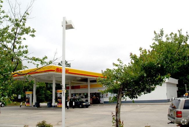
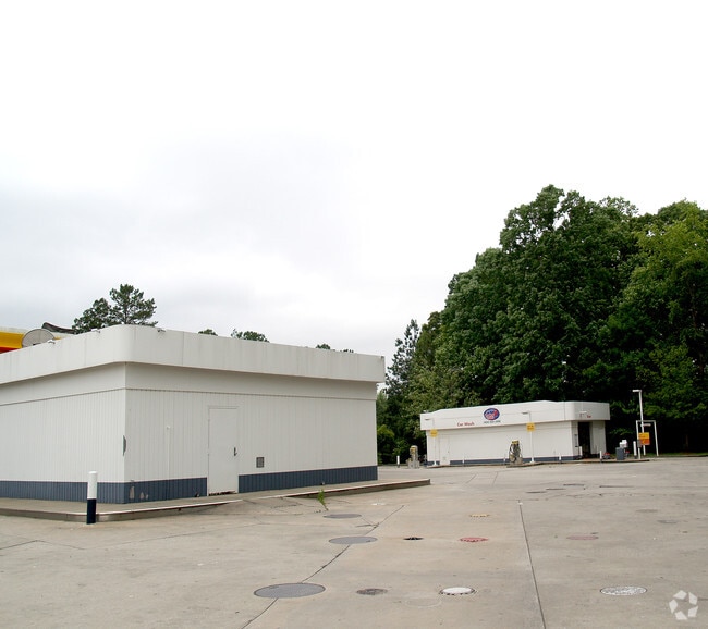
Property Record
Jonesboro Rd, South Fulton, GA 30296

NEARBY LISTINGS FOR SALE OR LEASE
Property Detail
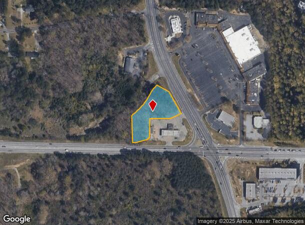
Jonesboro Rd
Atlanta-Sandy Springs-Roswell, GA
Alta/Acsm Land Title Surv
13-0188-LL-067-7
2275 HIGHWAY 138 10761 ALPHARETTA HWY 1338 VIRGINIA AVE 4597 JONESBORO RD 1892 HOWELL MILL RD NW 5700 ROSWELL RD 7800 HOLCOMBE BRIDGE RD LL188,485,535,130,386,63,153,91,
Commercialacreage
Fulton
X
Georgia
13063C0062F
1.54 AC
2024
S Fulton/Union City
2025
Atlanta
010537
DEMOGRAPHICS near Jonesboro Rd
1 Mile
3 Mile
5 Mile
2024 Total Population
4,003
49,537
159,443
2029 Population
4,108
50,475
162,029
Pop Growth 2024-2029
+ 2.62%
+ 1.89%
+ 1.62%
Average Age
39
39
37
2024 Total Households
1,302
17,549
59,399
HH Growth 2024-2029
+ 2.76%
+ 1.93%
+ 1.60%
Median Household Inc
$73,444
$65,198
$53,513
Avg Household Size
2.90
2.80
2.60
2024 Avg HH Vehicles
2.00
2.00
2.00
Median Home Value
$231,720
$191,964
$175,834
Median Year Built
1998
1989
1987
Nearby Places
- Restaurants
- Banks
- Shops
- Fitness
- Groceries
PUBLIC TRANSPORTATION
AIRPORT
Hartsfield - Jackson Atlanta International
DRIVE
WALK
Distance
Hartsfield - Jackson Atlanta International
19 min
10.2 mi
Freight Ports
Georgia Ports - Savannah
DRIVE
WALK
Distance
Georgia Ports - Savannah
273 min
241.8 mi
Nearby Properties
Address
Land Use
TOTAL SIZE
Lot Size
Zoning
Address
Land Use
TOTAL SIZE
Lot Size
Zoning
294 SF
21.17 AC
PUD
Address
Land Use
TOTAL SIZE
Lot Size
Zoning
3,904,656 SF
30.58 AC
RM
Address
Land Use
TOTAL SIZE
Lot Size
Zoning
278 SF
18.53 AC
PUD
Address
Land Use
TOTAL SIZE
Lot Size
Zoning
147,540 SF
47.10 AC
C RP
Address
Land Use
TOTAL SIZE
Lot Size
Zoning
481 SF
90.43 AC
RMH
Address
Land Use
TOTAL SIZE
Lot Size
Zoning
257,723 SF
28.76 AC
C1
Address
Land Use
TOTAL SIZE
Lot Size
Zoning
176 SF
17.67 AC
RM
Address
Land Use
TOTAL SIZE
Lot Size
Zoning
137,872 SF
14.23 AC
Address
Land Use
TOTAL SIZE
Lot Size
Zoning
93,568 SF
15.84 AC
R4C
Address
Land Use
TOTAL SIZE
Lot Size
Zoning
95,422 SF
17.28 AC
Address
Land Use
TOTAL SIZE
Lot Size
Zoning
86,781 SF
16 AC
RS110
Address
Land Use
TOTAL SIZE
Lot Size
Zoning
138,852 SF
6.72 AC
C CH
Address
Land Use
TOTAL SIZE
Lot Size
Zoning
105,795 SF
13.55 AC
C
Address
Land Use
TOTAL SIZE
Lot Size
Zoning
132,252 SF
14.33 AC
C1C
Address
Land Use
TOTAL SIZE
Lot Size
Zoning
39,498 SF
28.80 AC
GB
Address
Land Use
TOTAL SIZE
Lot Size
Zoning
97,408 SF
16.01 AC
C1
Address
Land Use
TOTAL SIZE
Lot Size
Zoning
78,669 SF
16.60 AC
C
Address
Land Use
TOTAL SIZE
Lot Size
Zoning
91,767 SF
19.83 AC
R4
Address
Land Use
TOTAL SIZE
Lot Size
Zoning
100,000 SF
8.96 AC
AG1
Address
Land Use
TOTAL SIZE
Lot Size
Zoning
40,014 SF
10.42 AC
GB
Address
Land Use
TOTAL SIZE
Lot Size
Zoning
108 SF
10.82 AC
RM
Address
Land Use
TOTAL SIZE
Lot Size
Zoning
84,645 SF
8.24 AC
C1
Address
Land Use
TOTAL SIZE
Lot Size
Zoning
67,595 SF
14.80 AC
RS180
Address
Land Use
TOTAL SIZE
Lot Size
Zoning
117,381 SF
5.97 AC
C1
Address
Land Use
TOTAL SIZE
Lot Size
Zoning
1,800 SF
169.19 AC
AR
Address
Land Use
TOTAL SIZE
Lot Size
Zoning
40,703 SF
7.44 AC
RM
Address
Land Use
TOTAL SIZE
Lot Size
Zoning
31,620 SF
4.99 AC
R4C
Address
Land Use
TOTAL SIZE
Lot Size
Zoning
29,208 SF
19.39 AC
Address
Land Use
TOTAL SIZE
Lot Size
Zoning
31,423 SF
16.47 AC
RS180
Address
Land Use
TOTAL SIZE
Lot Size
Zoning
66,855 SF
34.90 AC
The World's #1 Commercial Real Estate Marketplace
Connect with us
© 2025 CoStar Group
The information above has been obtained from sources believed reliable. While we do not doubt its accuracy we have not verified it and make no guarantee, warranty or representation about it. It is your responsibility to independently confirm its accuracy and completeness. Any projections, opinions, assumptions, or estimates used are for example only and do not represent the current or future performance of the property. The value of this transaction to you depends on tax and other factors which should be evaluated by your tax, financial, and legal advisors. You and your advisors should conduct a careful, independent investigation of the property to determine to your satisfaction the suitability of the property for your needs.