Property Record
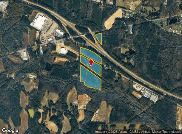
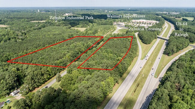
0 Old Us 264 Hwy, Zebulon, NC 27597

NEARBY LISTINGS FOR SALE OR LEASE
Property Detail
0 Old Us 264 Hwy
2715.01-05-5879-000
C D BUNN LD
Timberlandforesttreesagricultural
Wake
AE
North Carolina
3720271500M
30.39 AC
2025
Northeast Wake County
2025
Raleigh/Durham
054304
Raleigh, NC
DEMOGRAPHICS near 0 Old Us 264 Hwy
1 Mile
3 Mile
5 Mile
2024 Total Population
496
13,261
26,243
2029 Population
548
14,925
29,632
Pop Growth 2024-2029
+ 10.48%
+ 12.55%
+ 12.91%
Average Age
41
40
40
2024 Total Households
188
4,907
9,596
HH Growth 2024-2029
+ 10.64%
+ 12.57%
+ 12.99%
Median Household Inc
$82,558
$73,040
$71,947
Avg Household Size
2.60
2.70
2.70
2024 Avg HH Vehicles
2.00
2.00
2.00
Median Home Value
$456,666
$303,036
$264,019
Median Year Built
1991
1994
1995
Nearby Places
- Restaurants
- Banks
- Shops
- Fitness
- Groceries
PUBLIC TRANSPORTATION
AIRPORT
Raleigh-Durham International
DRIVE
WALK
Distance
Raleigh-Durham International
46 min
35.0 mi
Freight Ports
Port of Wilmington
DRIVE
WALK
Distance
Port of Wilmington
165 min
141.4 mi
SALE & LEASE HISTORY
LISTING DATE
SALE/LEASE

Jul 28, 2023
For Sale
Nearby Properties
Address
Land Use
TOTAL SIZE
Lot Size
Zoning
Address
Land Use
TOTAL SIZE
Lot Size
Zoning
684,322 SF
128.05 AC
LI
Address
Land Use
TOTAL SIZE
Lot Size
Zoning
122,602 SF
49.13 AC
IL
Address
Land Use
TOTAL SIZE
Lot Size
Zoning
403,424 SF
45.13 AC
LI
Address
Land Use
TOTAL SIZE
Lot Size
Zoning
169,147 SF
18.48 AC
OI
Address
Land Use
TOTAL SIZE
Lot Size
Zoning
102,726 SF
33.59 AC
OI
Address
Land Use
TOTAL SIZE
Lot Size
Zoning
193,130 SF
24.71 AC
HC
Address
Land Use
TOTAL SIZE
Lot Size
Zoning
267,518 SF
16.18 AC
HI
Address
Land Use
TOTAL SIZE
Lot Size
Zoning
83,419 SF
23.80 AC
R2
Address
Land Use
TOTAL SIZE
Lot Size
Zoning
151,485 SF
9.45 AC
HI
Address
Land Use
TOTAL SIZE
Lot Size
Zoning
33,656 SF
52.02 AC
CA-SU
Address
Land Use
TOTAL SIZE
Lot Size
Zoning
152,062 SF
8.80 AC
HI
Address
Land Use
TOTAL SIZE
Lot Size
Zoning
120,504 SF
13.76 AC
HC
Address
Land Use
TOTAL SIZE
Lot Size
Zoning
27,378 SF
12.71 AC
OI
Address
Land Use
TOTAL SIZE
Lot Size
Zoning
30,800 SF
3.79 AC
HC
Address
Land Use
TOTAL SIZE
Lot Size
Zoning
34,280 SF
5.41 AC
OI
Address
Land Use
TOTAL SIZE
Lot Size
Zoning
148,004 SF
8.80 AC
HI
Address
Land Use
TOTAL SIZE
Lot Size
Zoning
43,761 SF
9 AC
LI
Address
Land Use
TOTAL SIZE
Lot Size
Zoning
74,750 SF
5.69 AC
LI
Address
Land Use
TOTAL SIZE
Lot Size
Zoning
1,040 SF
285.26 AC
R-30
Address
Land Use
TOTAL SIZE
Lot Size
Zoning
68,222 SF
6.61 AC
HC
Address
Land Use
TOTAL SIZE
Lot Size
Zoning
58,776 SF
19.38 AC
HI
Address
Land Use
TOTAL SIZE
Lot Size
Zoning
36,816 SF
3.87 AC
RMF
Address
Land Use
TOTAL SIZE
Lot Size
Zoning
62,452 SF
7.07 AC
OI
Address
Land Use
TOTAL SIZE
Lot Size
Zoning
105,897 SF
24.39 AC
HI
Address
Land Use
TOTAL SIZE
Lot Size
Zoning
39,300 SF
3.07 AC
HC
Address
Land Use
TOTAL SIZE
Lot Size
Zoning
49,788 SF
2.61 AC
LI
Address
Land Use
TOTAL SIZE
Lot Size
Zoning
67,103 SF
8.38 AC
HI
Address
Land Use
TOTAL SIZE
Lot Size
Zoning
72,613 SF
11.12 AC
RMF
Address
Land Use
TOTAL SIZE
Lot Size
Zoning
14,459 SF
1.31 AC
DTP
Address
Land Use
TOTAL SIZE
Lot Size
Zoning
4,733 SF
3.40 AC
HC
The World's #1 Commercial Real Estate Marketplace
Connect with us
© 2025 CoStar Group
The information above has been obtained from sources believed reliable. While we do not doubt its accuracy we have not verified it and make no guarantee, warranty or representation about it. It is your responsibility to independently confirm its accuracy and completeness. Any projections, opinions, assumptions, or estimates used are for example only and do not represent the current or future performance of the property. The value of this transaction to you depends on tax and other factors which should be evaluated by your tax, financial, and legal advisors. You and your advisors should conduct a careful, independent investigation of the property to determine to your satisfaction the suitability of the property for your needs.