Property Record
14958 N Main St, Jacksonville, FL 32218
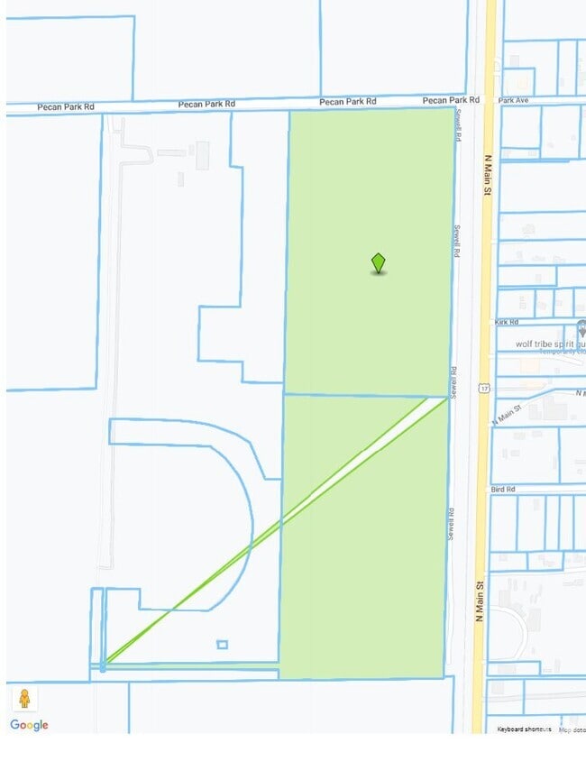
This Property Is For Sale
NEARBY LISTINGS FOR SALE OR LEASE
Property Detail
14958 N Main St
Jacksonville, FL
Tisons S/D Pt Seton Grant
108133-0000
1-150 40-1N-27E 31.08 TISONS S/D PT LOT 8 RECD O/R 20237-673, PT RW RW CLOSING RECD O/R 20633-1447 LYING E THEREOF
Industrialacreage
Duval
AH
Florida
12031C0065J
8
2025
33.09 AC
2026
Northeast Jacksonville
010308
Jacksonville (Florida)
DEMOGRAPHICS near 14958 N Main St
1 Mile
3 Mile
5 Mile
2024 Total Population
2,355
18,770
44,280
2029 Population
2,485
19,986
46,846
Pop Growth 2024-2029
+ 5.52%
+ 6.48%
+ 5.79%
Average Age
35
38
38
2024 Total Households
796
6,871
16,391
HH Growth 2024-2029
+ 5.65%
+ 6.85%
+ 6.15%
Median Household Inc
$101,342
$77,753
$75,424
Avg Household Size
2.80
2.60
2.60
2024 Avg HH Vehicles
2.00
2.00
2.00
Median Home Value
$264,999
$260,929
$263,223
Median Year Built
2010
2007
2004
Nearby Places
Map Layers
Map Styles
 Street
 Aerial
- Restaurants
- Banks
- Shops
- Fitness
- Groceries
PUBLIC TRANSPORTATION
AIRPORT
Jacksonville International
DRIVE
WALK
Distance
Jacksonville International
14 min
5.8 mi
Freight Ports
Jacksonville Port
DRIVE
WALK
Distance
Jacksonville Port
24 min
16.1 mi
Nearby Properties
Address
Land Use
TOTAL SIZE
Lot Size
Zoning
Address
Land Use
TOTAL SIZE
Lot Size
Zoning
344,800 SF
35.11 AC
PUD
Address
Land Use
TOTAL SIZE
Lot Size
Zoning
371,466 SF
42.67 AC
PUD
Address
Land Use
TOTAL SIZE
Lot Size
Zoning
226,421 SF
1.89 AC
PUD
Address
Land Use
TOTAL SIZE
Lot Size
Zoning
201,630 SF
21.59 AC
PUD
Address
Land Use
TOTAL SIZE
Lot Size
Zoning
307,351 SF
34.25 AC
PUD
Address
Land Use
TOTAL SIZE
Lot Size
Zoning
328,039 SF
18.88 AC
PUD
Address
Land Use
TOTAL SIZE
Lot Size
Zoning
240,988 SF
18.11 AC
PUD
Address
Land Use
TOTAL SIZE
Lot Size
Zoning
210,341 SF
8.84 AC
PUD
Address
Land Use
TOTAL SIZE
Lot Size
Zoning
640,660 SF
28.30 AC
PUD
Address
Land Use
TOTAL SIZE
Lot Size
Zoning
317,695 SF
15.88 AC
PUD
Address
Land Use
TOTAL SIZE
Lot Size
Zoning
317,815 SF
17.56 AC
PUD
Address
Land Use
TOTAL SIZE
Lot Size
Zoning
163,276 SF
8.39 AC
PUD
Address
Land Use
TOTAL SIZE
Lot Size
Zoning
197,526 SF
11.98 AC
PUD
Address
Land Use
TOTAL SIZE
Lot Size
Zoning
226,572 SF
9.24 AC
PUD
Address
Land Use
TOTAL SIZE
Lot Size
Zoning
264,117 SF
22.48 AC
PUD
Address
Land Use
TOTAL SIZE
Lot Size
Zoning
117,647 SF
10.17 AC
PUD
Address
Land Use
TOTAL SIZE
Lot Size
Zoning
201,300 SF
15.83 AC
PUD
Address
Land Use
TOTAL SIZE
Lot Size
Zoning
48,309 SF
4.03 AC
CCG-1
Address
Land Use
TOTAL SIZE
Lot Size
Zoning
86,637 SF
8.09 AC
CCG-1
Address
Land Use
TOTAL SIZE
Lot Size
Zoning
90,363 SF
11.12 AC
PUD
Address
Land Use
TOTAL SIZE
Lot Size
Zoning
235,864 SF
18.14 AC
PUD
Address
Land Use
TOTAL SIZE
Lot Size
Zoning
110,968 SF
5.75 AC
PUD
Address
Land Use
TOTAL SIZE
Lot Size
Zoning
28,653 SF
2.89 AC
PUD
Address
Land Use
TOTAL SIZE
Lot Size
Zoning
81,802 SF
9.34 AC
PUD
Address
Land Use
TOTAL SIZE
Lot Size
Zoning
125,300 SF
13.34 AC
PUD
Address
Land Use
TOTAL SIZE
Lot Size
Zoning
28,892 SF
3.39 AC
PUD
Address
Land Use
TOTAL SIZE
Lot Size
Zoning
28,377 SF
2.30 AC
CCG-1
Address
Land Use
TOTAL SIZE
Lot Size
Zoning
36,288 SF
2.24 AC
CCG-1
Address
Land Use
TOTAL SIZE
Lot Size
Zoning
109,840 SF
9.08 AC
PUD
Address
Land Use
TOTAL SIZE
Lot Size
Zoning
32,744 SF
3.68 AC
CCG-1
The World's #1 Commercial Real Estate Marketplace
Connect with us
© 2026 CoStar Group
The information above has been obtained from sources believed reliable. While we do not doubt its accuracy we have not verified it and make no guarantee, warranty or representation about it. It is your responsibility to independently confirm its accuracy and completeness. Any projections, opinions, assumptions, or estimates used are for example only and do not represent the current or future performance of the property. The value of this transaction to you depends on tax and other factors which should be evaluated by your tax, financial, and legal advisors. You and your advisors should conduct a careful, independent investigation of the property to determine to your satisfaction the suitability of the property for your needs.