Property Record
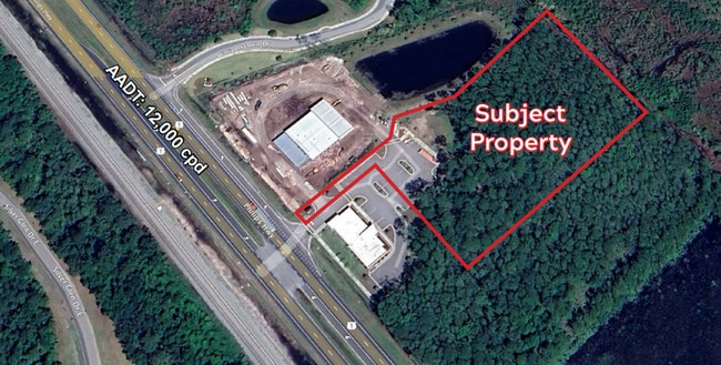
Philips Hwy, Jacksonville, FL 32256

NEARBY LISTINGS FOR SALE OR LEASE
Property Detail
Philips Hwy
Jacksonville (Florida)
Section Land
Jacksonville, FL
48-4S-28E 2.98 CHRISTOPHER MINCHIN GRANT PT RECD O/R 18843-1905 (EX PT RECD O/R 20370-1311)
168170-0027
Duval
Commercialacreage
Florida
2025
2.98 AC
2026
Butler/Baymeadows
014426
DEMOGRAPHICS near Philips Hwy
1 Mile
3 Mile
5 Mile
2024 Total Population
3,618
34,987
84,587
2029 Population
4,159
40,898
104,668
Pop Growth 2024-2029
+ 14.95%
+ 16.89%
+ 23.74%
Average Age
38
37
37
2024 Total Households
1,315
13,268
30,267
HH Growth 2024-2029
+ 15.21%
+ 15.78%
+ 22.14%
Median Household Inc
$112,793
$101,594
$114,836
Avg Household Size
2.80
2.60
2.80
2024 Avg HH Vehicles
2.00
2.00
2.00
Median Home Value
$368,900
$365,964
$401,076
Median Year Built
2010
2010
2010
Nearby Places
Map Layers
Map Styles
 Street
 Aerial
- Restaurants
- Banks
- Shops
- Fitness
- Groceries
PUBLIC TRANSPORTATION
AIRPORT
Jacksonville International
DRIVE
WALK
Distance
Jacksonville International
43 min
33.1 mi
Freight Ports
Jacksonville Port
DRIVE
WALK
Distance
Jacksonville Port
33 min
22.1 mi
SALE & LEASE HISTORY
LISTING DATE
SALE/LEASE

Jul 11, 2025
For Sale
Nearby Properties
Address
Land Use
TOTAL SIZE
Lot Size
Zoning
Address
Land Use
TOTAL SIZE
Lot Size
Zoning
534,591 SF
39.81 AC
PUD
Address
Land Use
TOTAL SIZE
Lot Size
Zoning
357,256 SF
16.28 AC
PUD
Address
Land Use
TOTAL SIZE
Lot Size
Zoning
663,789 SF
70.22 AC
Address
Land Use
TOTAL SIZE
Lot Size
Zoning
470,627 SF
21.61 AC
PUD
Address
Land Use
TOTAL SIZE
Lot Size
Zoning
450,888 SF
27.01 AC
PUD
Address
Land Use
TOTAL SIZE
Lot Size
Zoning
381,269 SF
25.73 AC
PUD
Address
Land Use
TOTAL SIZE
Lot Size
Zoning
211,499 SF
74.05 AC
Address
Land Use
TOTAL SIZE
Lot Size
Zoning
243,751 SF
15.29 AC
PUD
Address
Land Use
TOTAL SIZE
Lot Size
Zoning
340,852 SF
19.65 AC
PUD
Address
Land Use
TOTAL SIZE
Lot Size
Zoning
311,304 SF
18.93 AC
PUD
Address
Land Use
TOTAL SIZE
Lot Size
Zoning
298,018 SF
15.53 AC
PUD
Address
Land Use
TOTAL SIZE
Lot Size
Zoning
246,901 SF
14.02 AC
PUD
Address
Land Use
TOTAL SIZE
Lot Size
Zoning
212,510 SF
19.07 AC
CRO
Address
Land Use
TOTAL SIZE
Lot Size
Zoning
241,882 SF
10.83 AC
PUD
Address
Land Use
TOTAL SIZE
Lot Size
Zoning
427,236 SF
69.60 AC
PUD
Address
Land Use
TOTAL SIZE
Lot Size
Zoning
300,726 SF
11.99 AC
Address
Land Use
TOTAL SIZE
Lot Size
Zoning
378,384 SF
21 AC
Address
Land Use
TOTAL SIZE
Lot Size
Zoning
288,257 SF
16.56 AC
Address
Land Use
TOTAL SIZE
Lot Size
Zoning
276,262 SF
10.01 AC
PUD
Address
Land Use
TOTAL SIZE
Lot Size
Zoning
264,962 SF
11.24 AC
PUD
Address
Land Use
TOTAL SIZE
Lot Size
Zoning
262,043 SF
10.89 AC
PUD
Address
Land Use
TOTAL SIZE
Lot Size
Zoning
141,912 SF
5.02 AC
PUD
Address
Land Use
TOTAL SIZE
Lot Size
Zoning
289,228 SF
38.96 AC
Address
Land Use
TOTAL SIZE
Lot Size
Zoning
265,356 SF
23.72 AC
PUD
Address
Land Use
TOTAL SIZE
Lot Size
Zoning
159,391 SF
36.52 AC
PUD
Address
Land Use
TOTAL SIZE
Lot Size
Zoning
356,254 SF
22.04 AC
PUD
Address
Land Use
TOTAL SIZE
Lot Size
Zoning
283,584 SF
22.06 AC
Address
Land Use
TOTAL SIZE
Lot Size
Zoning
270,101 SF
20.03 AC
Address
Land Use
TOTAL SIZE
Lot Size
Zoning
171,277 SF
7.36 AC
PUD
Address
Land Use
TOTAL SIZE
Lot Size
Zoning
84,096 SF
12.75 AC
OR
The World's #1 Commercial Real Estate Marketplace
Connect with us
© 2026 CoStar Group
The information above has been obtained from sources believed reliable. While we do not doubt its accuracy we have not verified it and make no guarantee, warranty or representation about it. It is your responsibility to independently confirm its accuracy and completeness. Any projections, opinions, assumptions, or estimates used are for example only and do not represent the current or future performance of the property. The value of this transaction to you depends on tax and other factors which should be evaluated by your tax, financial, and legal advisors. You and your advisors should conduct a careful, independent investigation of the property to determine to your satisfaction the suitability of the property for your needs.