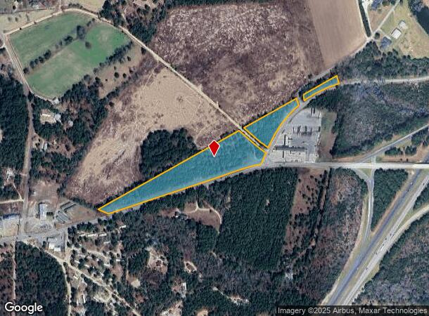
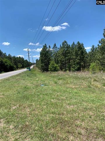
Property Record
Pond Branch Rd, Gilbert, SC 29054

NEARBY LISTINGS FOR SALE OR LEASE
-
-
View all Gilbert listings for sale on LoopNet.com
Property Detail
Pond Branch Rd
008400-02-116
TRACTS B,C & D
Commercialacreage
Lexington
X
South Carolina
45063C0335J
9.76 AC
2025
Outlying Lexington County
2024
Columbia
021306
Columbia, SC
DEMOGRAPHICS near Pond Branch Rd
1 mile
3 mile
5 mile
2024 Total Population
404
3,979
10,741
2029 Population
442
4,369
11,809
Pop Growth 2024-2029
+ 9.41%
+ 9.80%
+ 9.94%
Average Age
41
40
39
2024 Total Households
158
1,510
4,040
HH Growth 2024-2029
+ 9.49%
+ 9.87%
+ 10.05%
Median Household Inc
$55,199
$56,108
$57,597
Avg Household Size
2.50
2.60
2.60
2024 Avg HH Vehicles
2.00
2.00
2.00
Median Home Value
$171,951
$190,265
$193,633
Median Year Built
1993
1993
1993
Nearby Places
Map Layers
Map Styles
 Street
 Aerial
Transit
 Traffic
 Biking
Places
Listings with unknown addresses are not visible on the map
- Restaurants
- Banks
- Shops
- Fitness
- Groceries
PUBLIC TRANSPORTATION
AIRPORT
Columbia Metro
Drive
Walk
Distance
Columbia Metro
37 min
19.6 mi
Freight Ports
North Charleston Terminal
Drive
Walk
Distance
North Charleston Terminal
140 min
121.3 mi
SALE & LEASE HISTORY
LISTING DATE
SALE/LEASE

Jun 25, 2021
For Sale
Nearby Properties
Address
Land Use
TOTAL SIZE
Lot Size
Zoning
Address
Land Use
TOTAL SIZE
Lot Size
Zoning
468.99 AC
RD
Address
Land Use
TOTAL SIZE
Lot Size
Zoning
13,103 SF
14.88 AC
ID
Address
Land Use
TOTAL SIZE
Lot Size
Zoning
9,100 SF
1.54 AC
ID
Address
Land Use
TOTAL SIZE
Lot Size
Zoning
9,600 SF
14.06 AC
RD
Address
Land Use
TOTAL SIZE
Lot Size
Zoning
2,275 SF
2 AC
RD
Address
Land Use
TOTAL SIZE
Lot Size
Zoning
924 SF
14.14 AC
ID
Address
Land Use
TOTAL SIZE
Lot Size
Zoning
3,291 SF
4.38 AC
RD
Address
Land Use
TOTAL SIZE
Lot Size
Zoning
3,585 SF
80.21 AC
RD
Address
Land Use
TOTAL SIZE
Lot Size
Zoning
7,680 SF
4.79 AC
LR
Address
Land Use
TOTAL SIZE
Lot Size
Zoning
5,544 SF
20.53 AC
ID
Address
Land Use
TOTAL SIZE
Lot Size
Zoning
1,479 SF
8.86 AC
RD
Address
Land Use
TOTAL SIZE
Lot Size
Zoning
2,172 SF
8 AC
RD
Address
Land Use
TOTAL SIZE
Lot Size
Zoning
2,859 SF
1.02 AC
Address
Land Use
TOTAL SIZE
Lot Size
Zoning
3,444 SF
0.96 AC
RD
Address
Land Use
TOTAL SIZE
Lot Size
Zoning
1,593 SF
0.86 AC
RD
Address
Land Use
TOTAL SIZE
Lot Size
Zoning
4,126 SF
12.95 AC
RD
Address
Land Use
TOTAL SIZE
Lot Size
Zoning
4,357 SF
6.70 AC
ID
Address
Land Use
TOTAL SIZE
Lot Size
Zoning
4,338 SF
6.42 AC
RD
Address
Land Use
TOTAL SIZE
Lot Size
Zoning
1,474 SF
17.48 AC
RD
Address
Land Use
TOTAL SIZE
Lot Size
Zoning
2,766 SF
1.85 AC
RD
Address
Land Use
TOTAL SIZE
Lot Size
Zoning
2,096 SF
5 AC
RD
Address
Land Use
TOTAL SIZE
Lot Size
Zoning
2,800 SF
1.80 AC
ID
Address
Land Use
TOTAL SIZE
Lot Size
Zoning
2,442 SF
7.16 AC
RD
Address
Land Use
TOTAL SIZE
Lot Size
Zoning
1,342 SF
5 AC
RD
Address
Land Use
TOTAL SIZE
Lot Size
Zoning
4,249 SF
9.10 AC
RD
Address
Land Use
TOTAL SIZE
Lot Size
Zoning
1,364 SF
89.38 AC
RD
Address
Land Use
TOTAL SIZE
Lot Size
Zoning
471 SF
10 AC
RD
Address
Land Use
TOTAL SIZE
Lot Size
Zoning
57.62 AC
RD
Address
Land Use
TOTAL SIZE
Lot Size
Zoning
3,318 SF
38.25 AC
RD
Address
Land Use
TOTAL SIZE
Lot Size
Zoning
2,089 SF
1.13 AC
RD
The World's #1 Commercial Real Estate Marketplace
Connect with us
© 2026 CoStar Group
The information above has been obtained from sources believed reliable. While we do not doubt its accuracy we have not verified it and make no guarantee, warranty or representation about it. It is your responsibility to independently confirm its accuracy and completeness. Any projections, opinions, assumptions, or estimates used are for example only and do not represent the current or future performance of the property. The value of this transaction to you depends on tax and other factors which should be evaluated by your tax, financial, and legal advisors. You and your advisors should conduct a careful, independent investigation of the property to determine to your satisfaction the suitability of the property for your needs.