Property Record
2304 Reed Rd, Houston, TX 77051
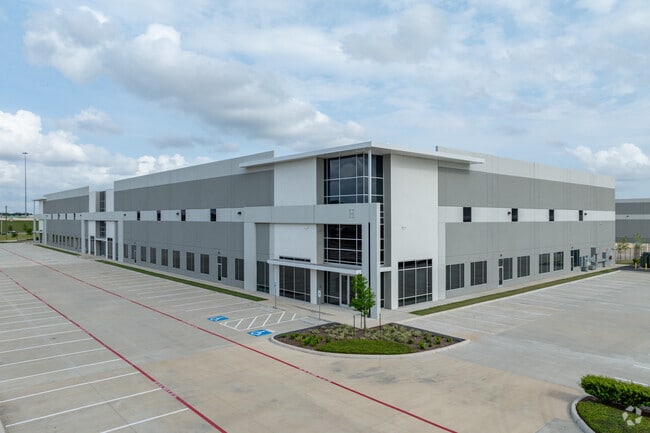


Property Detail
2304 Reed Rd
Houston-Pasadena-The Woodlands, TX
RES A BLK 1 LONE STAR LOGISTICS PARK
1453360010001
HARRIS
Warehouse
Texas
2024
52.18 AC
2025
South Hwy 35
334101
Houston
651,551 SF
NEARBY LISTINGS FOR SALE OR LEASE
DEMOGRAPHICS near 2304 Reed Rd
1 mile
3 mile
5 mile
2025 Total Population
4,304
113,298
338,627
2030 Population
4,675
122,272
364,753
Pop Growth 2025-2030
+ 8.62%
+ 7.92%
+ 7.72%
Average Age
35
36
37
2025 Total Households
1,639
47,810
131,380
HH Growth 2025-2030
+ 8.72%
+ 8.13%
+ 8.15%
Median Household Inc
$42,500
$56,188
$65,253
Avg Household Size
2.60
2.30
2.40
2025 Avg HH Vehicles
1.00
1.00
2.00
Median Home Value
$222,083
$209,158
$274,647
Median Year Built
2005
1988
1986
Nearby Places
Map Layers
Map Styles
 Street
 Aerial
Layers
 Traffic
 Biking
Places
Listings with unknown addresses are not visible on the map
- Restaurants
- Banks
- Shops
- Fitness
- Groceries
PUBLIC TRANSPORTATION
COMMUTER RAIL
Houston (Sunset Limited - Amtrak)
Drive
Walk
Distance
Houston (Sunset Limited - Amtrak)
15 min
9.0 mi
AIRPORT
William P Hobby
Drive
Walk
Distance
William P Hobby
22 min
10.2 mi
George Bush Intcntl/Houston
Drive
Walk
Distance
George Bush Intcntl/Houston
35 min
26.3 mi
Freight Ports
Port of Houston
Drive
Walk
Distance
Port of Houston
21 min
12.4 mi
SALE & LEASE HISTORY
LISTING DATE
SALE/LEASE

Sep 21, 2021
For Lease
Jul 20, 2023
For Lease
Nearby Properties
Address
Land Use
TOTAL SIZE
Lot Size
Zoning
Address
Land Use
TOTAL SIZE
Lot Size
Zoning
1,359,194 SF
Address
Land Use
TOTAL SIZE
Lot Size
Zoning
402,467 SF
28.30 AC
Address
Land Use
TOTAL SIZE
Lot Size
Zoning
507,499 SF
7.66 AC
Address
Land Use
TOTAL SIZE
Lot Size
Zoning
577,327 SF
28.80 AC
Address
Land Use
TOTAL SIZE
Lot Size
Zoning
284,836 SF
4.22 AC
Address
Land Use
TOTAL SIZE
Lot Size
Zoning
499,978 SF
5.57 AC
Address
Land Use
TOTAL SIZE
Lot Size
Zoning
643,698 SF
6.57 AC
Address
Land Use
TOTAL SIZE
Lot Size
Zoning
354,377 SF
8.10 AC
Address
Land Use
TOTAL SIZE
Lot Size
Zoning
365,485 SF
13.94 AC
Address
Land Use
TOTAL SIZE
Lot Size
Zoning
257,963 SF
6.39 AC
Address
Land Use
TOTAL SIZE
Lot Size
Zoning
518,025 SF
18.09 AC
Address
Land Use
TOTAL SIZE
Lot Size
Zoning
53,600 SF
21.34 AC
Address
Land Use
TOTAL SIZE
Lot Size
Zoning
460,438 SF
3.37 AC
Address
Land Use
TOTAL SIZE
Lot Size
Zoning
593,742 SF
15.79 AC
Address
Land Use
TOTAL SIZE
Lot Size
Zoning
28.22 AC
Address
Land Use
TOTAL SIZE
Lot Size
Zoning
542,367 SF
18.58 AC
Address
Land Use
TOTAL SIZE
Lot Size
Zoning
181,517 SF
0.66 AC
Address
Land Use
TOTAL SIZE
Lot Size
Zoning
476,754 SF
4.14 AC
Address
Land Use
TOTAL SIZE
Lot Size
Zoning
446,567 SF
2.21 AC
Address
Land Use
TOTAL SIZE
Lot Size
Zoning
378,704 SF
4.24 AC
Address
Land Use
TOTAL SIZE
Lot Size
Zoning
422,115 SF
6.18 AC
Address
Land Use
TOTAL SIZE
Lot Size
Zoning
292,644 SF
15.47 AC
Address
Land Use
TOTAL SIZE
Lot Size
Zoning
261,824 SF
10 AC
Address
Land Use
TOTAL SIZE
Lot Size
Zoning
413,336 SF
24.57 AC
Address
Land Use
TOTAL SIZE
Lot Size
Zoning
432,938 SF
4.31 AC
Address
Land Use
TOTAL SIZE
Lot Size
Zoning
51.50 AC
Address
Land Use
TOTAL SIZE
Lot Size
Zoning
660,480 SF
28.96 AC
Address
Land Use
TOTAL SIZE
Lot Size
Zoning
388,566 SF
3.38 AC
Address
Land Use
TOTAL SIZE
Lot Size
Zoning
255,680 SF
13.42 AC
The World's #1 Commercial Real Estate Marketplace
Connect with us
© 2026 CoStar Group
The information above has been obtained from sources believed reliable. While we do not doubt its accuracy we have not verified it and make no guarantee, warranty or representation about it. It is your responsibility to independently confirm its accuracy and completeness. Any projections, opinions, assumptions, or estimates used are for example only and do not represent the current or future performance of the property. The value of this transaction to you depends on tax and other factors which should be evaluated by your tax, financial, and legal advisors. You and your advisors should conduct a careful, independent investigation of the property to determine to your satisfaction the suitability of the property for your needs.