Property Record
9115 Risdon School Rd, Marissa, IL 62257
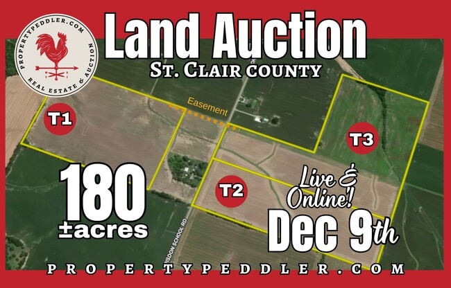
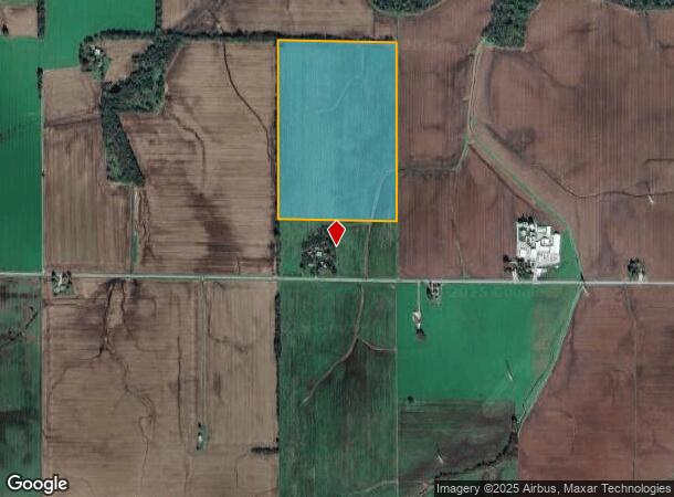

This Property Is For Sale
NEARBY LISTINGS FOR SALE OR LEASE
-
-
View all Marissa listings for sale on LoopNet.com
Property Detail
9115 Risdon School Rd
St. Louis
Lenzburg Twp
St. Louis, MO-IL
LENZBURG TWP SEC 26 LOT/SEC-26-SUBL/TWP-3S-BLK/RG-7W LOT 2 PT SE 60 AC A02739511
20-26.0-400-002
St. Clair
Agriculturalland
Illinois
2024
2
2024
60.36 AC
504002
Illinois
DEMOGRAPHICS near 9115 Risdon School Rd
1 mile
3 mile
5 mile
2024 Total Population
28
219
3,684
2029 Population
28
222
3,703
Pop Growth 2024-2029
0.00%
+ 1.37%
+ 0.52%
Average Age
43
43
43
2024 Total Households
11
87
1,545
HH Growth 2024-2029
0.00%
+ 2.30%
+ 0.52%
Median Household Inc
$37,500
$49,166
$54,554
Avg Household Size
2.40
2.50
2.40
2024 Avg HH Vehicles
2.00
2.00
2.00
Median Home Value
$174,999
$186,666
$137,268
Median Year Built
1969
1972
1966
Nearby Places
Map Layers
Map Styles
 Street
 Aerial
Transit
 Traffic
 Biking
Places
Listings with unknown addresses are not visible on the map
- Restaurants
- Banks
- Shops
- Fitness
- Groceries
PUBLIC TRANSPORTATION
AIRPORT
Scott AFB/Midamerica St Louis
Drive
Walk
Distance
Scott AFB/Midamerica St Louis
58 min
30.9 mi
Freight Ports
Port Milwaukee
Drive
Walk
Distance
Port Milwaukee
462 min
392.4 mi
Nearby Properties
Address
Land Use
TOTAL SIZE
Lot Size
Zoning
Address
Land Use
TOTAL SIZE
Lot Size
Zoning
87 AC
Address
Land Use
TOTAL SIZE
Lot Size
Zoning
Address
Land Use
TOTAL SIZE
Lot Size
Zoning
3,209 SF
6.39 AC
Address
Land Use
TOTAL SIZE
Lot Size
Zoning
2,610 SF
4.84 AC
Address
Land Use
TOTAL SIZE
Lot Size
Zoning
2,418 SF
40.58 AC
Address
Land Use
TOTAL SIZE
Lot Size
Zoning
Address
Land Use
TOTAL SIZE
Lot Size
Zoning
Address
Land Use
TOTAL SIZE
Lot Size
Zoning
4.95 AC
Address
Land Use
TOTAL SIZE
Lot Size
Zoning
8.76 AC
Address
Land Use
TOTAL SIZE
Lot Size
Zoning
4,250 SF
7.12 AC
Address
Land Use
TOTAL SIZE
Lot Size
Zoning
Address
Land Use
TOTAL SIZE
Lot Size
Zoning
1,959 SF
5.46 AC
Address
Land Use
TOTAL SIZE
Lot Size
Zoning
218.59 AC
Address
Land Use
TOTAL SIZE
Lot Size
Zoning
1,023 SF
8.64 AC
Address
Land Use
TOTAL SIZE
Lot Size
Zoning
2,602 SF
2.66 AC
Address
Land Use
TOTAL SIZE
Lot Size
Zoning
2,306 SF
6.55 AC
Address
Land Use
TOTAL SIZE
Lot Size
Zoning
Address
Land Use
TOTAL SIZE
Lot Size
Zoning
2,608 SF
60.71 AC
Address
Land Use
TOTAL SIZE
Lot Size
Zoning
10.95 AC
Address
Land Use
TOTAL SIZE
Lot Size
Zoning
1,672 SF
39.85 AC
Address
Land Use
TOTAL SIZE
Lot Size
Zoning
1,056 SF
64.90 AC
Address
Land Use
TOTAL SIZE
Lot Size
Zoning
2,212 SF
40.59 AC
Address
Land Use
TOTAL SIZE
Lot Size
Zoning
Address
Land Use
TOTAL SIZE
Lot Size
Zoning
1,246 SF
5 AC
Address
Land Use
TOTAL SIZE
Lot Size
Zoning
1,900 SF
25.31 AC
Address
Land Use
TOTAL SIZE
Lot Size
Zoning
1,120 SF
33.75 AC
Address
Land Use
TOTAL SIZE
Lot Size
Zoning
The World's #1 Commercial Real Estate Marketplace
Connect with us
© 2026 CoStar Group
The information above has been obtained from sources believed reliable. While we do not doubt its accuracy we have not verified it and make no guarantee, warranty or representation about it. It is your responsibility to independently confirm its accuracy and completeness. Any projections, opinions, assumptions, or estimates used are for example only and do not represent the current or future performance of the property. The value of this transaction to you depends on tax and other factors which should be evaluated by your tax, financial, and legal advisors. You and your advisors should conduct a careful, independent investigation of the property to determine to your satisfaction the suitability of the property for your needs.