Property Record
0 Route 25, Ridge, NY 11961
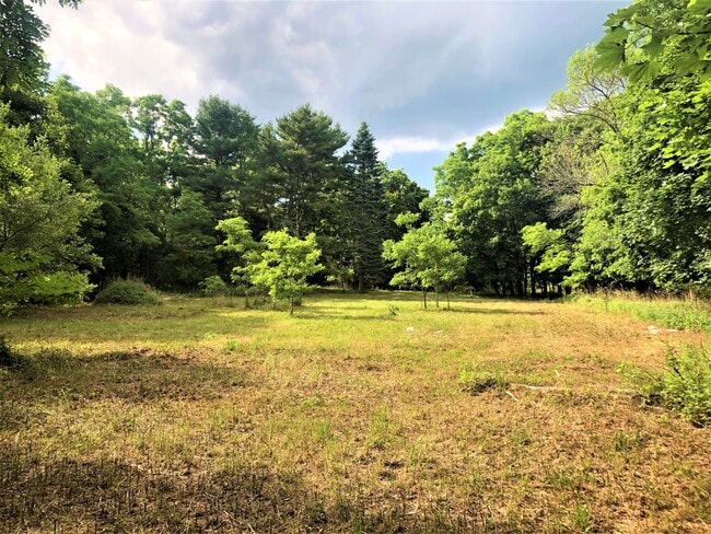
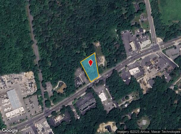
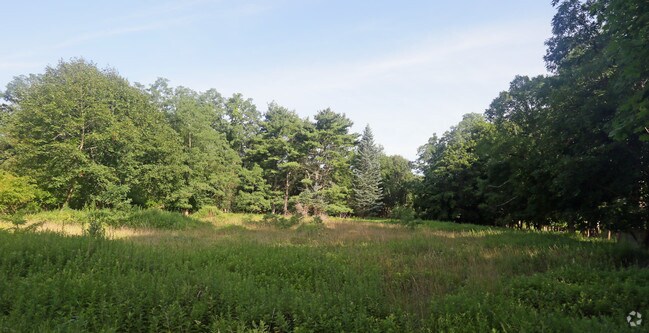
This Property Is For Sale
NEARBY LISTINGS FOR SALE OR LEASE
Property Detail
0 Route 25
Nassau County-Suffolk County, NY
Ridge
0200-351-00-01-00-003-000
N BRKHVN TOWN E NASEER S RTE 25 T10
Residentialacreage
Suffolk
X
New York
36103C0420H
3
2024
0.67 AC
2024
Central Suffolk
158409
Long Island (New York)
DEMOGRAPHICS near 0 Route 25
1 Mile
3 Mile
5 Mile
2024 Total Population
2,390
20,683
72,714
2029 Population
2,373
20,559
71,991
Pop Growth 2024-2029
(0.71%)
(0.60%)
(0.99%)
Average Age
41
47
43
2024 Total Households
832
9,165
26,664
HH Growth 2024-2029
(0.96%)
(0.45%)
(1.00%)
Median Household Inc
$120,152
$75,070
$99,380
Avg Household Size
2.70
2.20
2.60
2024 Avg HH Vehicles
2.00
2.00
2.00
Median Home Value
$407,552
$337,033
$387,174
Median Year Built
1979
1980
1978
Nearby Places
- Restaurants
- Banks
- Shops
- Fitness
- Groceries
PUBLIC TRANSPORTATION
COMMUTER RAIL
Yaphank Station (Greenport Branch - Long Island Rail Road)
DRIVE
WALK
Distance
Yaphank Station (Greenport Branch - Long Island Rail Road)
11 min
6.7 mi
Mastic-Shirley Station (Montauk Branch - Long Island Rail Road)
DRIVE
WALK
Distance
Mastic-Shirley Station (Montauk Branch - Long Island Rail Road)
14 min
8.4 mi
AIRPORT
Long Island MacArthur
DRIVE
WALK
Distance
Long Island MacArthur
31 min
19.1 mi
Freight Ports
Port of New Haven
DRIVE
WALK
Distance
Port of New Haven
130 min
49.6 mi
Nearby Properties
Address
Land Use
TOTAL SIZE
Lot Size
Zoning
Address
Land Use
TOTAL SIZE
Lot Size
Zoning
1,180.32 AC
Address
Land Use
TOTAL SIZE
Lot Size
Zoning
1.68 AC
Address
Land Use
TOTAL SIZE
Lot Size
Zoning
7.31 AC
LI200
Address
Land Use
TOTAL SIZE
Lot Size
Zoning
6.82 AC
LI200
Address
Land Use
TOTAL SIZE
Lot Size
Zoning
9,220 SF
2.66 AC
R40
Address
Land Use
TOTAL SIZE
Lot Size
Zoning
Address
Land Use
TOTAL SIZE
Lot Size
Zoning
2,579 SF
0.06 AC
VILLA
Address
Land Use
TOTAL SIZE
Lot Size
Zoning
48.38 AC
Address
Land Use
TOTAL SIZE
Lot Size
Zoning
17.62 AC
Address
Land Use
TOTAL SIZE
Lot Size
Zoning
571 AC
Address
Land Use
TOTAL SIZE
Lot Size
Zoning
0.07 AC
VILLA
Address
Land Use
TOTAL SIZE
Lot Size
Zoning
18.67 AC
Address
Land Use
TOTAL SIZE
Lot Size
Zoning
17.30 AC
Address
Land Use
TOTAL SIZE
Lot Size
Zoning
Address
Land Use
TOTAL SIZE
Lot Size
Zoning
29.45 AC
Address
Land Use
TOTAL SIZE
Lot Size
Zoning
Address
Land Use
TOTAL SIZE
Lot Size
Zoning
Address
Land Use
TOTAL SIZE
Lot Size
Zoning
Address
Land Use
TOTAL SIZE
Lot Size
Zoning
398 AC
Address
Land Use
TOTAL SIZE
Lot Size
Zoning
0.07 AC
VILLA
Address
Land Use
TOTAL SIZE
Lot Size
Zoning
Address
Land Use
TOTAL SIZE
Lot Size
Zoning
Address
Land Use
TOTAL SIZE
Lot Size
Zoning
1.66 AC
Address
Land Use
TOTAL SIZE
Lot Size
Zoning
Address
Land Use
TOTAL SIZE
Lot Size
Zoning
Address
Land Use
TOTAL SIZE
Lot Size
Zoning
20.44 AC
Address
Land Use
TOTAL SIZE
Lot Size
Zoning
349.60 AC
Address
Land Use
TOTAL SIZE
Lot Size
Zoning
Address
Land Use
TOTAL SIZE
Lot Size
Zoning
Address
Land Use
TOTAL SIZE
Lot Size
Zoning
The World's #1 Commercial Real Estate Marketplace
Connect with us
© 2025 CoStar Group
The information above has been obtained from sources believed reliable. While we do not doubt its accuracy we have not verified it and make no guarantee, warranty or representation about it. It is your responsibility to independently confirm its accuracy and completeness. Any projections, opinions, assumptions, or estimates used are for example only and do not represent the current or future performance of the property. The value of this transaction to you depends on tax and other factors which should be evaluated by your tax, financial, and legal advisors. You and your advisors should conduct a careful, independent investigation of the property to determine to your satisfaction the suitability of the property for your needs.