Property Record
1006 S 339Th Ave, Tonopah, AZ 85354


Property Detail
1006 S 339Th Ave
Phoenix-Mesa-Chandler, AZ
BUTTERFIELD STAGECOACH FARMS MCR 430-27
504-13-060
MARICOPA
Residentialacreage
Arizona
R-190
31
C and X Area of minimal flood hazard, usually depicted on FIRMs as above the 500-year flood level.
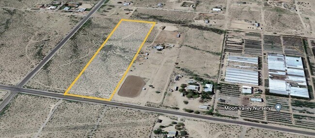
9.72 AC
2025
Southwest Outlying
2025
Phoenix
050603
NEARBY LISTINGS FOR SALE OR LEASE
-
-
View all Tonopah listings for lease on LoopNet.com
DEMOGRAPHICS near 1006 S 339Th Ave
1 mile
3 mile
5 mile
2025 Total Population
334
3,232
7,986
2030 Population
355
3,457
8,558
Pop Growth 2025-2030
+ 6.29%
+ 6.96%
+ 7.16%
Average Age
38
39
38
2025 Total Households
102
1,004
2,487
HH Growth 2025-2030
+ 6.86%
+ 7.07%
+ 7.24%
Median Household Inc
$72,856
$73,439
$74,099
Avg Household Size
2.90
2.90
3.00
2025 Avg HH Vehicles
2.00
3.00
3.00
Median Home Value
$359,999
$357,031
$373,912
Median Year Built
2001
2002
2004
Nearby Places
Map Layers
Map Styles
 Street
 Aerial
Layers
 Traffic
 Biking
Places
Listings with unknown addresses are not visible on the map
- Restaurants
- Banks
- Shops
- Fitness
- Groceries
SALE & LEASE HISTORY
LISTING DATE
SALE/LEASE

Nov 01, 2024
For Lease
Jul 19, 2021
For Sale
Nearby Properties
Address
Land Use
TOTAL SIZE
Lot Size
Zoning
Address
Land Use
TOTAL SIZE
Lot Size
Zoning
60,090 SF
12.93 AC
R-43
Address
Land Use
TOTAL SIZE
Lot Size
Zoning
43,747 SF
41.32 AC
C-2
Address
Land Use
TOTAL SIZE
Lot Size
Zoning
28.68 AC
Address
Land Use
TOTAL SIZE
Lot Size
Zoning
6.54 AC
Address
Land Use
TOTAL SIZE
Lot Size
Zoning
1.70 AC
Address
Land Use
TOTAL SIZE
Lot Size
Zoning
2.21 AC
R-43
Address
Land Use
TOTAL SIZE
Lot Size
Zoning
Address
Land Use
TOTAL SIZE
Lot Size
Zoning
900 SF
27.29 AC
Address
Land Use
TOTAL SIZE
Lot Size
Zoning
141 SF
27.57 AC
R-43
Address
Land Use
TOTAL SIZE
Lot Size
Zoning
2.51 AC
Address
Land Use
TOTAL SIZE
Lot Size
Zoning
1.25 AC
Address
Land Use
TOTAL SIZE
Lot Size
Zoning
Address
Land Use
TOTAL SIZE
Lot Size
Zoning
Address
Land Use
TOTAL SIZE
Lot Size
Zoning
1.25 AC
Address
Land Use
TOTAL SIZE
Lot Size
Zoning
0.92 AC
Address
Land Use
TOTAL SIZE
Lot Size
Zoning
1.10 AC
Address
Land Use
TOTAL SIZE
Lot Size
Zoning
1.03 AC
Address
Land Use
TOTAL SIZE
Lot Size
Zoning
1.03 AC
Address
Land Use
TOTAL SIZE
Lot Size
Zoning
1.03 AC
Address
Land Use
TOTAL SIZE
Lot Size
Zoning
1.03 AC
Address
Land Use
TOTAL SIZE
Lot Size
Zoning
1.40 AC
RU43
Address
Land Use
TOTAL SIZE
Lot Size
Zoning
1.10 AC
Address
Land Use
TOTAL SIZE
Lot Size
Zoning
1.10 AC
Address
Land Use
TOTAL SIZE
Lot Size
Zoning
1.10 AC
Address
Land Use
TOTAL SIZE
Lot Size
Zoning
1.10 AC
Address
Land Use
TOTAL SIZE
Lot Size
Zoning
9.87 AC
Address
Land Use
TOTAL SIZE
Lot Size
Zoning
7,662 SF
49.89 AC
R-43
Address
Land Use
TOTAL SIZE
Lot Size
Zoning
80.02 AC
RU43
Address
Land Use
TOTAL SIZE
Lot Size
Zoning
1.18 AC
The World's #1 Commercial Real Estate Marketplace
Connect with us
© 2026 CoStar Group
The information above has been obtained from sources believed reliable. While we do not doubt its accuracy we have not verified it and make no guarantee, warranty or representation about it. It is your responsibility to independently confirm its accuracy and completeness. Any projections, opinions, assumptions, or estimates used are for example only and do not represent the current or future performance of the property. The value of this transaction to you depends on tax and other factors which should be evaluated by your tax, financial, and legal advisors. You and your advisors should conduct a careful, independent investigation of the property to determine to your satisfaction the suitability of the property for your needs.