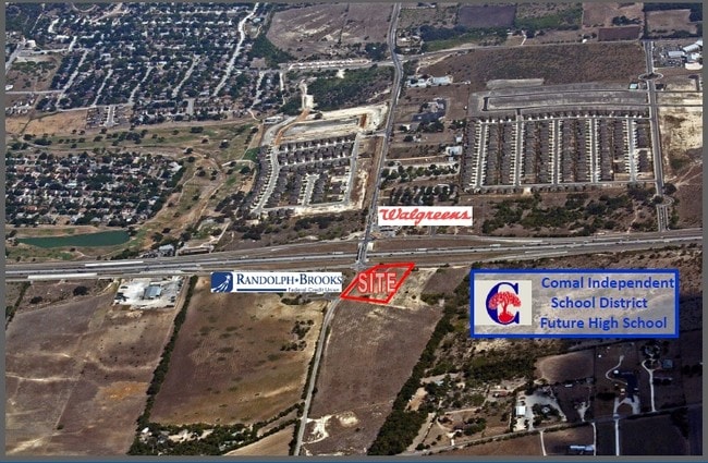
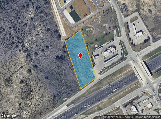
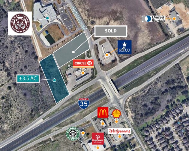
Property Record
0 S Ih 35, Schertz, TX 78154

Property Detail
0 S Ih 35
San Antonio-New Braunfels, TX
A-175 SUR- 98 R GARZA, ACRES 3.497
74-0175-0067-00
COMAL
Vacantlandnec
Texas
B and X Area of moderate flood hazard, usually the area between the limits of the 100-year and 500-year floods.
3.50 AC
2024
Comal County
2025
San Antonio
210706
NEARBY LISTINGS FOR SALE OR LEASE
DEMOGRAPHICS near 0 S Ih 35
1 mile
3 mile
5 mile
2025 Total Population
6,019
34,510
87,452
2030 Population
6,592
38,440
97,749
Pop Growth 2025-2030
+ 9.52%
+ 11.39%
+ 11.77%
Average Age
36
37
38
2025 Total Households
1,922
10,910
29,765
HH Growth 2025-2030
+ 10.04%
+ 11.92%
+ 12.34%
Median Household Inc
$107,617
$119,307
$112,950
Avg Household Size
3.10
3.20
2.90
2025 Avg HH Vehicles
2.00
2.00
2.00
Median Home Value
$330,599
$360,252
$349,266
Median Year Built
2009
2009
2006
Nearby Places
Map Layers
Map Styles
 Street
 Aerial
Layers
 Traffic
 Biking
Places
Listings with unknown addresses are not visible on the map
- Restaurants
- Banks
- Shops
- Fitness
- Groceries
PUBLIC TRANSPORTATION
AIRPORT
San Antonio International
Drive
Walk
Distance
San Antonio International
23 min
17.4 mi
SALE & LEASE HISTORY
LISTING DATE
SALE/LEASE

May 03, 2021
For Sale
Feb 21, 2020
For Sale
Nearby Properties
Address
Land Use
TOTAL SIZE
Lot Size
Zoning
Address
Land Use
TOTAL SIZE
Lot Size
Zoning
3,428 SF
1.78 AC
Address
Land Use
TOTAL SIZE
Lot Size
Zoning
361,563 SF
53.38 AC
Address
Land Use
TOTAL SIZE
Lot Size
Zoning
151,529 SF
18.40 AC
Address
Land Use
TOTAL SIZE
Lot Size
Zoning
55,640 SF
24.17 AC
Address
Land Use
TOTAL SIZE
Lot Size
Zoning
94,020 SF
40.08 AC
Address
Land Use
TOTAL SIZE
Lot Size
Zoning
90,699 SF
16.47 AC
Address
Land Use
TOTAL SIZE
Lot Size
Zoning
223,965 SF
14.45 AC
Address
Land Use
TOTAL SIZE
Lot Size
Zoning
86,124 SF
9.37 AC
Address
Land Use
TOTAL SIZE
Lot Size
Zoning
73,813 SF
17.33 AC
Address
Land Use
TOTAL SIZE
Lot Size
Zoning
112,870 SF
13.32 AC
Address
Land Use
TOTAL SIZE
Lot Size
Zoning
126,334 SF
30.38 AC
Address
Land Use
TOTAL SIZE
Lot Size
Zoning
103,044 SF
13.50 AC
Address
Land Use
TOTAL SIZE
Lot Size
Zoning
30,994 SF
29.09 AC
Address
Land Use
TOTAL SIZE
Lot Size
Zoning
19,650 SF
32.94 AC
Address
Land Use
TOTAL SIZE
Lot Size
Zoning
202,165 SF
23.97 AC
Address
Land Use
TOTAL SIZE
Lot Size
Zoning
263,165 SF
4.81 AC
Address
Land Use
TOTAL SIZE
Lot Size
Zoning
77,010 SF
10 AC
Address
Land Use
TOTAL SIZE
Lot Size
Zoning
308,670 SF
20.07 AC
Address
Land Use
TOTAL SIZE
Lot Size
Zoning
220,975 SF
12.52 AC
Address
Land Use
TOTAL SIZE
Lot Size
Zoning
159,112 SF
9.80 AC
Address
Land Use
TOTAL SIZE
Lot Size
Zoning
161,280 SF
17.85 AC
Address
Land Use
TOTAL SIZE
Lot Size
Zoning
151,044 SF
10.99 AC
Address
Land Use
TOTAL SIZE
Lot Size
Zoning
46,654 SF
7.04 AC
Address
Land Use
TOTAL SIZE
Lot Size
Zoning
110,162 SF
2.67 AC
Address
Land Use
TOTAL SIZE
Lot Size
Zoning
168,610 SF
9.51 AC
Address
Land Use
TOTAL SIZE
Lot Size
Zoning
38,192 SF
19.86 AC
Address
Land Use
TOTAL SIZE
Lot Size
Zoning
130,700 SF
9.64 AC
Address
Land Use
TOTAL SIZE
Lot Size
Zoning
158,224 SF
9.80 AC
Address
Land Use
TOTAL SIZE
Lot Size
Zoning
89,104 SF
13.86 AC
Address
Land Use
TOTAL SIZE
Lot Size
Zoning
112,850 SF
6.89 AC
The World's #1 Commercial Real Estate Marketplace
Connect with us
© 2026 CoStar Group
The information above has been obtained from sources believed reliable. While we do not doubt its accuracy we have not verified it and make no guarantee, warranty or representation about it. It is your responsibility to independently confirm its accuracy and completeness. Any projections, opinions, assumptions, or estimates used are for example only and do not represent the current or future performance of the property. The value of this transaction to you depends on tax and other factors which should be evaluated by your tax, financial, and legal advisors. You and your advisors should conduct a careful, independent investigation of the property to determine to your satisfaction the suitability of the property for your needs.